
Superelevation views are a graphic representation of the roadway superelevation. Grip edits to the graphical view will also edit the superelevation stations. The view itself is not intended for plotting. The superelevation view plots station against lane slope to form a sort of profile of the left and right edge of pavement.
At first glance, the superelevation view may seem difficult to read, but with a little explanation it can shed a lot of light on what is going on with your lane slopes. Figure 11-19 shows the superelevation diagram for a two-lane road that contains a reverse curve. The superelevation graphic plots the station value against the percent cross-slope of each edge of pavement. The upper line shows the behavior of the right edge of the pavement, and the lower line shows the left edge of the pavement.
Figure 11-19: The superelevation view
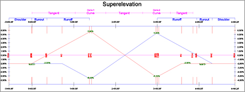
Where no superelevation is applied, the graph data is flat. As the assembly twists into position during superelevation, the distances between the lines becomes greater as the right edge slopes up to a maximum superelevation of 5.6%. You can also see in Figure 11-19 how Civil 3D has resolved overlap between the two curves. Neither line goes back to the default position at -2.00% until the end of the alignment. The crisscross in the center indicates that the roadway transitions directly from one max super to the other.
Place the view into Civil 3D by selecting the alignment and clicking Superelevation ⇒ Create Superelevation view. To simplify the view and make it easier to edit, you can choose which lanes to show or hide at the bottom of the view, as shown in Figure 11-20. You should also change the colors for left and right edge of pavement by clicking the ByBlock option and changing it to the color of your choice.
Figure 11-20: Creating a superelevation view

To modify superelevation data using the graphic, click on it to activate the numerous grips. Figure 11-21 shows a close-up of some of the grips you will see.
Figure 11-21: Grip-editing is another method for fine-tuning your superelevation stationing.
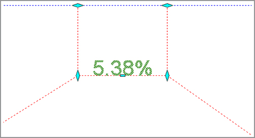
The diamond-shaped grips can be slid in one axis to modify stationing (the horizontally oriented grips) or slope (the vertically oriented grips). The rectangular grip can be moved to reduce the maximum lane slope when it is in a full-super state.
Superelevation: It’s Not Just for Highways
Don’t get trapped into thinking that just because you don’t do highway design, you can’t use some of the same tools. Some firms use superelevation to help design waterslides. The fun in learning Civil 3D is finding new ways to use the tools intended to solve one problem to address another problem entirely. You’ll know you’ve mastered the software when you find yourself using the tools in this manner.