
Chapter 2. Positioning technologies
- Defining positioning technologies
- Cell tower triangulation
- Satellite navigation, or GPS
- Cell ID
- Wireless positioning systems
- Emerging positioning methods
In the previous chapter, we provided an overview of location-based services so that you now understand what these are and why they’re experiencing such a dramatic growth in demand from mobile subscribers. We also introduced positioning technologies as the key component underpinning all LBS apps and services. We’re now ready to go into more detail so that you can make the right choice of positioning technology according to the application you wish to develop.
To understand the importance of choosing the right positioning technology, let’s use a simple example. Let’s say that you’ve developed an application that uses GPS satellite navigation to locate where you are and then continuously displays your location on a map of the city. A user downloads your application to his phone, activates it, and then forgets about it for 30 minutes. After this period, he flips his phone open and gets a dead-battery signal. Not a great user experience, huh?
Well, up until only a couple of years ago, this was common for most users of LBS on mobile devices. If we exclude smartphones for the moment, one way to solve this problem on a standard mobile device would be to program the application to use Cell ID as default positioning (allowing the user to switch to GPS if required). This would extend the battery life and allow the user to carry on using his mobile device as normal.
In this chapter, we’ll look at all the key positioning technologies being used within applications to make the mobile device automatically location aware, namely, cell tower triangulation, satellite navigation (sat nav) positioning, Cell ID, and wireless positioning.
We’ll begin by examining the existing positioning techniques commonly used today for mobile applications before transitioning to discuss the new positioning methods recently developed.[1] These new positioning methods include hybrid positioning, P-Cell (or Parameterized Cell) technology, and inertial measurement unit (IMU) technology. We’ll also touch on the principle of push versus pull positioning, because it has a bearing on location privacy, which is discussed further in chapter 10.
1 Less widespread or niche positioning technologies include Uplink Time Difference of Arrival (U-TDOA), Angle of Arrival (AOA), and Enhanced Observed Time Difference (E-OTD). You can read more about these at http://en.wikipedia.org/wiki/Mobile_phone_tracking.
Knowing which method or combination of methods to use is important for developers because it can affect the performance of the mobile application, and there’s sometimes a need to strike a balance between accuracy of the user’s location and other factors like speed of location fix or battery consumption.
Smartphones have overcome many of the problems of positioning technologies by using hybrid positioning, delivering accurate location with limited battery usage. However, though much improved compared to its use on a standard phone, an active GPS connection on a smartphone will still drain the battery relatively quickly.
Although smartphones (such as the iPhone) are increasing in importance and make up approximately 20% of the global handset market, standard phones still make up the remaining 80%. And here’s the thing: while location on smartphones tends to come neatly wrapped up in standard APIs that many developers don’t venture into, on standard phones savvy developers make or break location-based applications according to how well they can optimize the positioning capabilities of the handset.
To make it easier for developers to strike the balance between accuracy of positioning, cost of obtaining an accurate position, and maximizing battery usage when developing applications, each section of this chapter about the different technologies includes a summary of their key advantages and disadvantages for mobile applications.
2.1. What are positioning technologies?
The terms positioning or location technologies (the positioning component presented first in chapter 1) refer to the technology within the mobile device that lets you know where the device is at any point in time (to different degrees of accuracy). These technologies are a combination of hardware (for example, a GPS chip) and software (for example, code written to read the location obtained from cell tower signals).
All location technologies have their advantages as well as their drawbacks, which is why today the most common approach for LBS application developers is to use location APIs native to each mobile development platform. These APIs tend to be optimized for location (often integrating hybrid location, mentioned previously).
This section aims to give you an overview of the four main positioning technologies commonly used today: cell tower triangulation, GPS, Cell ID, and WPS. We’ll specifically focus on the advantages and disadvantages of each, to give developers the best shot at delivering the best LBS application to mobile subscribers.
Before we look at the main location technologies introduced in chapter 1 in a bit more detail, it’s worth understanding the principle behind the initial technology, cell tower triangulation. Although in many ways this is old technology, it’s still the basis for emergency location services, and its principle of triangulation also underpins some of the newer positioning methods commonly available today. A grasp of how this works will allow you to better understand how all the other positioning methods work as well.
2.1.1. Cell tower triangulation
Cell tower triangulation uses the known speed of radio signals (constantly emitted by the mobile phone on UHF frequencies) to calculate the distance from receivers.[2] In geometric terms, by recording the distance of an object from three distinct points, it’s possible to calculate the location of that object (indeed, this principle was the basis for early calculations of the distance between the earth and the moon).
2 Chris “Silver” Smith, “Cell Phone Triangulation Accuracy Is All Over the Map,” September 22, 2008, www.searchengineland.com.
The receivers or antennas can be existing cell towers, or they can be located on tall buildings in urban environments. It takes at least three and preferably four receivers to get a good location fix. In densely populated locations, the accuracy of the fix tends to be high (up to 200 meters or 700 feet precision) because there’ll be more cell towers with their signal radii overlapping. This is illustrated in figure 2.1, where the overlap between three cell towers is used to determine the cell phone’s location.
Figure 2.1. Cell tower triangulation works by detecting distance of a cell phone from the radii of three separate cell towers. The cell phone’s location is where the three radii overlap (figure courtesy of Chris “Silver” Smith at mng.bz/OQf3).

The accuracy of the location fix will increase further where directional antennae are installed on the cell tower, allowing for detection of not just distance but direction of the cell phone signal.
Rural locations tend to have low densities of transmitting antennae, and where the cell signal is picked up by one antenna only, the precision will fall dramatically (to several kilometers).
Because cell tower triangulation is a network-based localization technique, it requires an agreement with the mobile operator in order to adopt it within a mobile service. In the United States, the E-911 legislation makes it obligatory for mobile operators to allow government agencies to locate cell phone users via cell tower triangulation in case of emergencies.[3] Although commercial services exist that make use of cell tower triangulation (for instance, mobile navigation services like Telmap), in practice their expense and operator restrictions mean that most location-based services today bypass this technology in favor of either Cell ID, GPS, or Wi-Fi positioning (or, increasingly, a combination of all three).
3 In the late 1990s, the FCC created wireless Enhanced 911 rules that require cell phone providers to report the telephone number of a wireless 911 caller, the location of the antenna that received the call, and information about the signal’s location to within 50 to 300 meters. Next Generation 9-1-1 (NG9-1-1) networks will soon replace the existing narrowband, circuit-switched 9-1-1 networks, which carry only voice and very limited data. Currently there are difficulties in supporting such things as text messages for emergencies, images and video (including support for American Sign Language users), and easy access to additional data such as telematics data, building plans, and medical information over a common data network.
2.1.2. Satellite navigation GPSFor simplicity, this section refers to th- he American Navstar GPS GNSS (Global Navigation Satellite System) because this is the most commonly used GNSS for commercial purposes. However, as mentioned in chapter 1, alternative European (Galileo), Russian (next-generation GLONASS), and soon Chinese (COMPASS) GNSSs will be available.
GPS was originally developed by the US military in the 1970s. It was only made available for commercial use by the Pentagon in the mid ’90s after lobbying from private enterprises, which saw the enormous potential of the technology if made available to the public. Even then, the version made available to the public, SPS (Standard Positioning Service), was not as precise as the version reserved for the military, PPS (Precise Positioning Service). Ironically, commercial entities have sought to improve on the precision of standard GPS purely to make up for the deliberate degradation of this accuracy by the US Department of Defense.
Because standard GPS still provides the vanilla method for positioning for most LBS applications, we’ll look at this first and move on to consider how Assisted GPS (A-GPS) can be a useful alternative where a more reliable location fix with GPS is required. And because battery drainage remains the main issue with GPS, this section will round off by considering a solution that allows the use of GPS without draining the mobile device’s battery.
GPS still remains the most accurate positioning technology commercially available today to mobile developers (up to a maximum precision of 4 meters, meaning that it’s precise enough to locate the device within the radius of a large bedroom). It’s also free to the end user, the only cost being the GPS chip itself, which is included in the price of the device. By understanding how GPS and its variants (like A-GPS) work, developers can master what is (and is likely to be for a while still) the predominant positioning technology used today.
2.1.3. Standard GPS
The Global Positioning System, or GPS (which is still controlled by the US Department of Defense), uses a constellation of 31 satellites orbiting the earth. GPS determines the device’s position by calculating differences in the times signals from different satellites take to reach the receiver. The satellites orbit the earth at programmed altitudes, and they act as reference points in the sky (see figure 2.2, showing the programmed orbit of satellite GPS BIIA-28 on a given day).
Figure 2.2. Planned orbit ellipse of GPS BIIA-28 satellite around the earth (courtesy of NASA) as of June 7, 2009, at 11:10 a.m. GMT

GPS navigators use the mathematical technique of trilateration to determine user position, speed, and elevation. GPS receivers constantly receive and analyze radio signals from GPS satellites, calculating precise distance (range) to each satellite being tracked. Distance is calculated mathematically by taking into consideration both the velocity of the satellite moving in its orbit and the time it takes for its signal to be detected back on earth.
Data from a single satellite narrows a cell phone position to a large area of the earth’s surface. Adding data from a second satellite narrows position to the region where two spheres overlap. Adding data from a third satellite (see figure 2.3) provides relatively accurate positioning. Data from a fourth satellite (or more) enhances precision and also the ability to determine accurate elevation or altitude (in the case of aircraft). GPS receivers routinely track four to seven or more satellites simultaneously.
Figure 2.3. Triangulating from three different satellites allows a cell phone’s position to be narrowed down to one of two points, point A or point B, where the three spheres representing three separate satellite fixes intersect.

If a GPS navigator is receiving insufficient satellite data (not able to track enough satellites), it will notify the user rather than provide incorrect position information. Although GPS is potentially the most accurate method (between 4 and 40 meters if the GPS receiver has a clear view of the sky), it has some drawbacks: It heavily consumes a cell phone’s battery while in use and requires some warm-up after a cold start to get an initial fix on visible satellites. It also suffers from “canyon effects” in cities, where satellite visibility is intermittent, as well as from multipath deflection, where the satellite signal bounces off from tall, glass-covered buildings, leading to position drift.[5]
5 Trimble GPS Tutorial (www.trimble.com/gps).
Using the location captured by GPS on a mobile device for use within a mobile application is relatively straightforward. The JavaScript code snippet in appendix A, listing A.1, is an example of how this is achieved while limiting battery power consumption.
Now that we’ve covered standard GPS, we’ll move on to look at how Assisted GPS provides an enhanced solution to improve the accuracy of a location fix obtained via GPS
2.1.4. Assisted GPS
The truth today remains that there’s no universally recognized definition for A-GPS, given the multitude of ways in which this technology can be deployed (according to the configuration of chipset manufacturers, local legislation, and operator agreements) and the resulting variation in its effectiveness compared to GPS.
Fundamentally, A-GPS tries to address the key inescapable drawback of GPS technology, namely, that a location fix is impossible in most indoor or covered environments. The basic premise of A-GPS is to assist the embedded GPS chip within the handset in securing either a faster or more precise location fix in challenging conditions (such as a weak satellite signal or visibility of only two satellites instead of the required three for a location fix).
As we noted in the previous section, a GPS chip constantly scans the sky for orbit and clock data of the relevant satellites. This results in what’s known as the TTFF, or Time To First Fix, namely, the amount of time required for the GPS receiver to pinpoint your location. This initial TTFF is often called a cold start, and on SiRF III systems (the latest GPS systems available), it can take anywhere from 30 seconds to a couple of minutes to acquire a signal.[6]
6 Malatesta, “GPS vs A-GPS: A Quick Tutorial,” January 28, 2008, www.wmexperts.com.
When a phone is using A-GPS, the TTFF is much faster. Very often cellular network towers have GPS receivers (or a base station nearby), and those receivers are constantly pulling down ephemeris[7] data from the satellite and computing the data. This data is then passed on to the cell phone (when requested) and acts like a cheat because the relevant satellites to your location are already identified. GPS computations are handled by either third-party servers or by the handset chipset (that download the ephemeris data and insert the fix process to shortcut the correlation process with no further data network activity required). This allows a comparison of fragmentary GPS data received by the handset (because of few satellites being in line of sight, for example) with data from the network assistance server. This then allows a more precise calculation of position.
7 Ephemeris data gives the positions of astronomical objects in the sky at a given time or times.
Given that A-GPS is a relatively new development, it’s currently available on only a small proportion of the installed handset population, though most mobile manufacturers are now deploying it as standard in all their GPS-enabled phones.
For a developer of location-based services, A-GPS is a useful enhancement to underpin applications because it offers a faster location fix as well as saves battery life. The complications lie in the fact that the implementation of A-GPS can vary by operator and by manufacturer, requiring extended analysis and testing. It should also be noted that A-GPS works by transferring (location) data over the mobile operator network and thus will incur a data transfer charge for the mobile subscriber (whereas GPS is free).
A notable example of a departure from the standard implementation of A-GPS is that of Nokia, which offers A-GPS on all its new GPS-enabled models but does so by completely bypassing the operator. Nokia has developed its own proprietary database of the location of cell towers and embeds a form of cell triangulation within its Ovi Maps software (preinstalled on all Nokia GPS-enabled phones).
It’s important to note that long-term ephemeris, or parameterized ephemeris, can be found in common use in handsets. It’s very sophisticated and requires an A-GPS injection only once every few days (or only one download every few weeks in the more advanced versions). The iPhone is a notable user of this via the Hammerhead frontend/ baseband and Global Locate IP.
Listing A.2 in appendix A is the JavaScript code snippet that fetches the handset’s device for use within a Java application using A-GPS while limiting battery power consumption. As you’ll note, there’s only one extra line of code compared to the code for fetching a standard GPS location.
Having covered GPS positioning using the mobile device, we’ll now look at an alternative to obtaining the GPS position for use within a mobile application using an external device.
2.1.5. Bluetooth or standalone GPS
As we mentioned, one of the main drawbacks of GPS on mobile devices is its battery life constraint. One solution to this is the use of a separate, external GPS device connected to the mobile handset via Bluetooth (see the example shown in figure 2.4).
Figure 2.4. A Belkin Bluetooth GPS device that can be connected to a mobile phone to provide additional GPS functionality
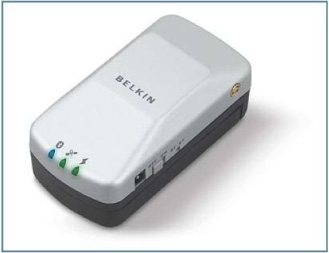
The advantages are that even lower-range mobile phones without inbuilt GPS can obtain this functionality through wireless connectivity with the external device; the quality of the GPS receiver is higher, thus ensuring faster and more precise location fixes; and battery life is significantly higher than an inbuilt GPS on a mobile device.
The main drawback is clearly that instead of carrying along one device, two are required, limiting mobility for this solution. This explains why an external Bluetooth GPS device is more typically used in motor vehicles paired to a cell phone as an alternative to a (more costly) in-car satellite navigation system. It’s also worth noting that the device can’t be connected to certain smartphones, such as the iPhone.
Summary of Advantages and Disadvantages of GPS
The fact that GPS has become such a mainstream technology available at low cost to mobile subscribers means that it’s still the most pervasive positioning technology for LBS applications. Table 2.1 summarizes some of the key advantages and disadvantages of GPS as a positioning method for LBS applications.
Table 2.1. Main advantages and disadvantages of GPS positioning technology for use within location-aware mobile applications
|
Disadvantages |
|
|---|---|
| Locates precisely to a maximum accuracy of 4 meters in optimal conditions. | Leads to rapid battery depletion. |
| Uses tried and tested technology. | Requires line of sight to a range of GPS satellites in the sky (i.e., doesn’t work indoors). |
| Is widely adopted among handset manufacturers. | Satellite signal can be deflected in certain urban environments, leading to position drift. |
| No extra cost to mobile subscriber (data charges applicable for A-GPS only). | The Time To First Fix (TTFF) can be slow compared to other positioning technologies. |
Now that we’ve looked at GPS positioning, and you have a better understanding of the advantages and disadvantages of using this technology, we’ll examine Cell ID positioning. Cell ID positioning is a useful complement to GPS mainly because of one key feature, its limited battery usage. Understanding Cell ID will allow developers to take this technology on board and, in many cases, make their applications more usable by limiting battery drainage.
2.2. Cell ID
In this section, after taking a look at what exactly we mean by Cell ID, we’ll consider sources of Cell ID information in the form of Cell ID databases, both paid and free, and clearly lay out the key advantages and disadvantages to developers of using this technology.
Cell ID has gained significantly in popularity as a positioning method in the last few years. We’ll now look at what has enabled the development of this technology, how it works, and the advantages (as well as the drawbacks) of choosing Cell ID to power LBSs.
Cell ID positioning is accomplished by using the serving cell tower (the tower that a mobile device is communicating with), or the cell, and its known position to find the mobile device’s position. Cell ID positioning is simple, can be done on the network or on the user device, and doesn’t require any upgrade to the handset.
Because one of the key drawbacks to using GPS within mobile applications is battery drainage, programmers should carefully consider the GPS polling frequency they require to obtain a location fix for their application. By reducing the polling frequency to, say, once every 30 minutes instead of continuously, dramatic battery consumption savings can be made. Caching the last-known location of the user can also be used to complement this strategy, so that location-specific information can be shown according to a relevant location until the next location fix is obtained.
The International Telecommunication Union (ITU), the United Nations intergovernmental fixed and mobile telecommunications regulatory body, assigns to each country a Mobile Country Code (MCC), and within each country a Mobile Network Code (MNC) is assigned to each cellular network operator. Each operator is responsible for creating the Location Area Codes (LAC) for their network and assigning a numeric identification to each cell (Cell ID). Whenever a mobile terminal is connected to the network, it’s associated to one of these cells. Therefore, the absolute location of a terminal can then be expressed by the four parameters Cell ID, LAC, MNC, and MCC.[8]
8 Filipe Meneses and Adriano Moreira, “Using GSM CellID Positioning for Place Discovering,” Department of Information Systems, University of Minho, Portugal.
The current Cell ID can be used to identify the base transceiver station (BTS) that the device is communicating with and the location of that BTS. Clearly, the accuracy of this method depends on the size of the cell, and the method can be quite inaccurate. A GSM network cell may be anywhere from 2 to 35 kilometers in diameter. The accuracy of a location fix using a single cell tower is typically in the range of 1to 2 kilometers. Other techniques used along with Cell ID can achieve accuracy within 150 meters.
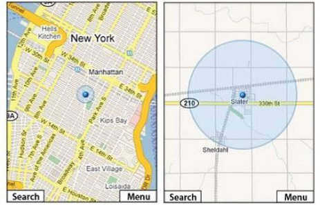
A very prominent user of Cell ID positioning technology on mobile devices is Google. Google’s Maps for Mobile service uses the transmission from a single cell tower to provide the cell phone location. This often leads to a disparity in accuracy between an urban and a rural environment, which can be seen in figure 2.5. In downtown New York City, the radius of the cell phone’s location is down to a few blocks, but in the rural town of Slater, it widens to several kilometers.
Figure 2.5. Comparison of the accuracy of cell tower detection used by Google Mobile Maps in an urban and a rural environment. Although the location picked up in downtown New York City is accurate to within a few hundred meters, in a rural town like Slater, the accuracy is reduced to several kilometers.
2.2.1. Cell ID databases
Cell ID location detection relies on the ability to map information detected on operator cells to a database of their precise location. Mobile network operators that own the cells don’t publish or provide access to their Cell ID database for a number of reasons, among which are privacy concerns, but perhaps more importantly commercial considerations (operators plan to charge for access to the data).
It’s worth noting that each positioning technology brings with it programming considerations when it comes to embedding its functionality within a mobile application. For example, given the maturity and relative widespread adoption of GPS, including code within a mobile application, using the location information from GPS is relatively straightforward. Both Cell ID and Wi-Fi positioning have additional development barriers; for example, certain original equipment manufacturers (OEMs) like Nokia don’t allow a JME application to obtain Cell ID info directly from their handset. These issues will be discussed in more detail in chapter 4.
Google Maps possesses its own Cell ID database, which is widely considered to be the most complete in the world. This accuracy is owed in no small measure to the widespread adoption of Google Maps on mobile devices over the last three years and the capture of location data from mobile users of their service to improve the initial Cell ID database.
For mobile applications other than the iPhone and Android (which embed Google Maps as the mapping component, thus making the use of their Cell ID database more or less mandatory), a number of other databases are available.
A number of commercial enterprises have built up their own Cell ID database and offer this for use to third parties. A notable example is Navizon, which offers a relatively complete global Cell ID database at a reasonable cost (approximately 100 Euros per month for its enterprise positioning system solution incorporating Cell ID at the time of this writing).
Increasingly, demand is growing for open source solutions when it comes to Cell ID, and this has given rise to the development of the OpenCellID movement.
Opencellid
The OpenCellID movement is an open source project that began to gain prominence in 2008 and is led by a France-based team. It currently claims to have mapped the location of over 600,000 cells[9] thanks to the crowd sourcing of Cell ID locations from around the world.
9 As of February 25, 2010. Source: www.opencellid.org.
The data from this open source project is available through a number of public APIs, which cover the following functions:
Listing A.3 in appendix A illustrates an example format in which the API key returns information on the user’s exact position.
More details on these API functions and the respective API keys are available at http://www.opencellid.org/api. Because the information contained within the Open-CellID database is shared using a Creative Commons license, it’s a free resource open to all developers. A word of caution is required though, because although the Open-CellID database is no doubt improving over time, it still offers patchy coverage at best. In some countries, like the UK, it covers roughly 45,000 cells (or just under 50% of the total), but in other countries, like Spain, it captures data from only 6,300 cells, covering less than 25% of the total.
Table 2.2 summarizes some of the key advantages and disadvantages of Cell ID as a positioning method for LBS applications.
Table 2.2. Main advantages and disadvantages of Cell ID positioning technology for use within location-aware mobile applications
|
Advantages |
Disadvantages |
|---|---|
| Available on a majority of handsets. | Relies on access to Cell ID databases in order to determine the cell location; good-quality databases charge for access. |
| Works indoors because it relies on the standard mobile operator network connection. | Because it relies on communication with a single cell, the accuracy of positioning is affected and is measured in kilometers instead of meters. |
| Energy efficient; has no significant impact on battery depletion. | Where cell towers are widely distributed, such as in non-urban environments, the accuracy of positioning drops, further limiting its usefulness. |
Now that we’ve covered Cell ID, we’ll look at wireless positioning systems as the newest kid on the block of positioning technologies.
2.3. Wireless positioning systems
Because wireless positioning systems (WPSs) are a relative newbie to the area of positioning technologies, a slight aura of mystery still surrounds them, and there are a few misconceptions as to how the technology works exactly.
This section will dispel some of these myths and provide a clear overview of the technology, as well as give the developer an idea of the benefits of using this method (and yes, again, with these benefits come some drawbacks, too!).
A key advantage of WPS, indicating they are a must-have for many mobile applications, is that they work indoors where traditionally GPS hasn’t been available. This is because GPS positioning requires a line of sight to the satellite. Several wireless internet standards are emerging in addition to standard Wi-Fi, such as WiMAX, but the principles of the positioning system remain unchanged.
There’s a common misconception that because Wi-Fi routers are often encrypted and password protected, Wi-Fi positioning won’t work (how can a signal be locked down if it’s being scrambled?). In fact, Wi-Fi positioning technologies don’t require access to the wireless network per se but only to the ID of the wireless transmission. This ID is then cross-referenced to a global database and used for determining the location of the device.
2.3.1. Wi-Fi hotspot detection
Wi-Fi positioning was first developed for commercial purposes by Skyhook Wireless in 2005 and has becoming increasing popular since it was incorporated into the iPhone 2G as the key positioning technology (prior to the 3G with the GPS chip becoming available).
The Wi-Fi positioning software uses 802.11 radio signals emitted from wireless routers to determine the precise location of any Wi-Fi–enabled device. When a mobile user running the Wi-Fi positioning client pops up in a neighborhood, the software scans for access points. It then calculates a user’s location by selecting several signals and comparing them to the reference database. The more densely populated the area is with Wi-Fi signals, the more accurate the software is at locating the device. Effectively, the same principles of cell tower triangulation are adopted as described earlier, but are used for detecting wireless router transmission signals instead of operator signal radio transmissions.
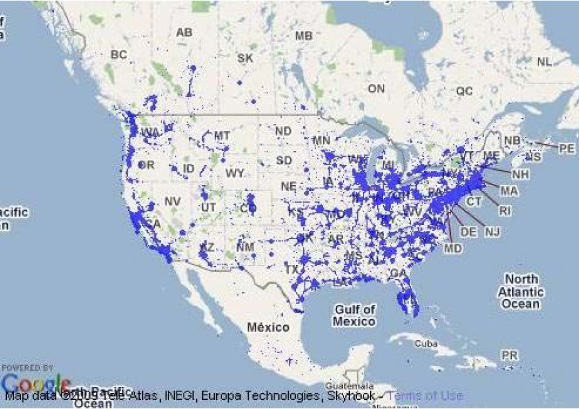
Skyhook Wireless claims to cover over 90% of cities in North America (see figure 2.6) and Europe and with a precision of 20 to 40 meters through its database of 100 million mapped wireless router transmissions. To develop this database, Skyhook deployed drivers to survey every single street, highway, and alley in tens of thousands of cities and towns worldwide, scanning for Wi-Fi access points and cell towers and plotting their precise geographic locations.
Figure 2.6. Skyhook Wireless’s Wi-Fi point coverage map derived from its database for North America
In this section, we looked at the three main positioning technologies commonly used within LBS applications today: GPS, Cell ID positioning, and WPS. None of these technologies is perfect, with each having specific advantages and disadvantages compared to the others. This has led to developers increasingly choosing a combination of the three technologies, something known as hybrid positioning. We’ll consider this next, while also considering what lies ahead in the near- and mid-term future for positioning technologies.
2.4. New positioning methods
Surprisingly, perhaps, the technological framework around positioning technologies didn’t evolve much for over a decade since GPS was first made available for commercial use. Since the late ’90s, though, the pace of development has picked up, driven by increased uptake of LBS services and their inclusion as a core offer within mobile operator portals. Key developments have focused on improving the reliability of positioning, with additional future challenges centered on using a mobile subscriber position for automated delivery of location-based messages (including those of a promotional nature).
As with GPS polling of the handset, it’s worth noting that Wi-Fi signal detection can also lead to battery drainage, though to a slightly lesser degree than GPS (see table 2.3).
Table 2.3. Main advantages and disadvantages of Wi-Fi positioning technology for use within location-aware mobile applications
|
Advantages |
Disadvantages |
|---|---|
| Offers remarkable accuracy, particularly in urban environments where the density of Wi-Fi broadcasts is high. | Requires a Wi-Fi–enabled handset, which currently limits its availability to mostly smartphone devices. |
| Has no extra costs to the mobile subscriber, because access to Wi-Fi hotspot databases to allow positioning is currently provided free of charge. | An active Wi-Fi scan on a mobile device may lead to rapid battery drainage on all but a handful of high-end devices. |
| The time to obtain a fix is low, providing fast positioning for use within mobile applications. | Requires service providers to constantly update their Wi-Fi hotspot database. Because this changes relatively frequently, some inaccuracy in the location fix is possible. |
| Because it does not require line of sight to a satellite or other transmitter, it allows indoor positioning in covered areas. |
2.4.1. Hybrid positioning
Hybrid positioning involves combining several positioning technologies (typically GPS, Cell ID, and Wi-Fi) to deliver a reliable, accurate, cost-efficient location within a mobile application at all times. It currently is deployed as a default in a number of smartphones, such as the iPhone and Android devices.
The knowledge of and utilization of hybrid positioning solutions is essential for developers deploying applications on the JME/Java platform. Here, the constraints of relying on a single positioning technology (see tables 2.1 and 2.2) mean that it isn’t possible to deliver a satisfactory user experience without some form of hybrid solution. This typically involves combining GPS or A-GPS with Cell ID positioning, given that Wi-Fi positioning methods are difficult to implement on JME platforms (for a number of reasons, explored in more detail in chapter 4).
It’s estimated that by 2014, 25% of all positioning solutions across the board will be hybrid-based ones,[10] though this percentage is likely to be much higher in specific mobile platforms (and is 100% on individual smartphone platforms).
10 ABI Research, January 2009; see mng.bz/MxWD.
2.4.2. P-Cell technology
This Korean technology attempts to overcome the issues surrounding location triangulation using conventional Cell ID, namely, accuracy and reliance on operator network cell size parameters.
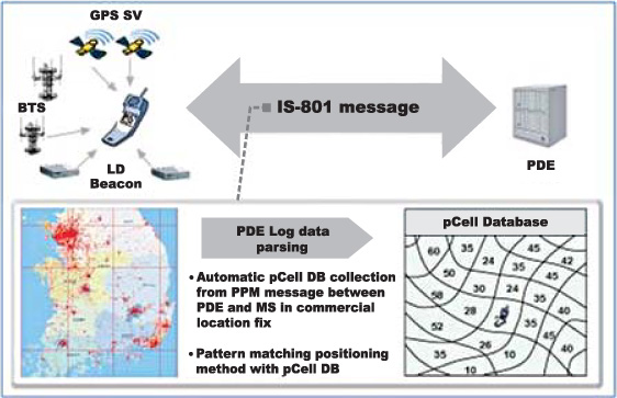
Instead of using conventional Cell ID, the new technology divides an area into predefined lattices of a predetermined size (shown in figure 2.5), which are mapped in a P-Cell database (where the P stands for Parameterized).
Then it continuously determines whether a request for location measurement occurs by a service subscriber; when the request for location measurement is generated, it compares fundamental information received from a mobile terminal with the P-Cell database, determines a matching P-Cell, and reports the matching P-Cell to the service subscriber. The advantages are that indoor location fixes are improved by about 70% (or so the technology patent says).
The system works like standard base tower signal triangulation (or trilateration, to be more precise), but instead of using the operator’s cell tower signal radii, it uses lattices of a standard dimension.
At the time of writing, P-Cell technology (see figure 2.7) hasn’t yet extended beyond its home territory in Korea, but the technology offers great potential in the future to improve on the accuracy of current Cell ID positioning.
Figure 2.7. Schematic description of how P-Cell technology is designed to capture a mobile device’s location (courtesy of CELIZION Inc., Korea)
2.4.3. IMU technology
An inertial measurement unit, or IMU, is an electronic device that has been used in avionics to measure and report on a craft’s velocity, orientation, and gravitational forces, using a combination of accelerometers and gyroscopes. IMUs are typically used to maneuver aircraft and spacecraft, including shuttles, satellites, and landers.
Advances in nanotechnology allow IMUs to be packaged in units of around 1 centimeter in length, making it possible to include them in smartphone devices. Figure 2.8 illustrates an accelerometer unit similar to the one included as standard in the iPhone and other smartphone devices, increasingly used with gyroscope units.
Figure 2.8. Picture of an STMicroelectronics LIS2L02AS two-axis accelerometer unit. On the left we have the standard view. On the right we see an X-ray image of the unit with micro-components, showing the MEMS (MicroElectroMechanicalSystems) and ASIC (application-specific integrated circuit) wire-bonded together and mounted side by side in the package. A three-axis version of this is incorporated in the iPhone and other smartphone devices to allow it to detect rotational attributes like pitch, roll, and yaw movements (source: mng.bz/kG2q).

IMUs can be used as positioning tools by calculating a current position based on velocity and time but without the need to communicate with any outside components, such as satellites. This method of navigation is called dead reckoning and is likely to become more popular as a positioning method to cover blackout situations such as tunnels and indoors.
It’s worth noting that accelerometers can also be used to determine whether the device has moved or is in movement. This is useful, as it can inform the device whether a fresh GPS location fix is required or not. It can also become part of location-aware application features because device movement can be used to trigger certain actions (like blocking SMS writing/editing if the speed of movement suggests the user is driving a vehicle, for example, and would create a hazard).
2.4.4. Push versus pull mechanisms
An important technological and social barrier for LBS is the ability to deliver targeted information (for example, marketing or promotional messages) according to the location of a mobile subscriber at a particular moment.
The social barrier arises from privacy concerns about tracking of a mobile subscriber’s location, which is examined later in this book. The technological barrier arises from the need to keep an LBS application running in the background of a mobile phone and allow it to wake up according to a combination of the user’s location and predetermined triggers (a geotagged message, for example). This is known as a push mechanism, referring to the automatic delivery of a notification to a mobile handset without the user specifically requesting the message (the other form of message delivery is referred to as a pull mechanism).
On standard mobile handsets (excluding smartphones) running an application in the background is impractical, particularly because of the battery drainage arising from the need for the GPS chip on the phone to constantly poll the satellite in order to determine the subscriber’s location.
An alternative on standard mobile handsets is to rely on a mobile network operator (MNO) and use the operator’s network to track a mobile subscriber’s location. The main benefit is that an accurate location can be constantly tracked without depleting the handset’s battery.
In practice, MNOs today are reticent to provide third-party access to their networks for location tracking for mass-market services (and are increasingly likely to charge for such access if they do provide it).
The future for push mechanisms is more likely to come from the smartphone segment, with the iPhone leading the way since the release of the OS 3.0 in the summer of 2009, which first allowed push notification. This has since been improved with the OS 4.0 launched in 2010 (and now joined by Android OS for versions 2.2 or later), which allows background processes to be kept running and promises to enable future LBS applications to finally deliver push notifications in a simple yet effective manner.
2.5. Summary
In this chapter, we looked at the key positioning technologies available for delivering LBS applications to mobile subscribers, charting the progression from the earlier methods to the likely future technological scenarios. Hybrid positioning is rapidly establishing itself as the new gold standard to ensure good performance of LBS applications. While push mechanisms are not yet fully deployable, it’s only a matter of time before they become widely available, pointing to a raft of new, exciting consumer applications. The next chapter will delve into the diverse and engaging set of consumer LBS applications that are already gathering a substantial following around the world.