
Chapter 5. Consumer applications
This chapter covers
- Applications for navigating to a destination
- Applications for connecting to other people or local places
- Applications to provide entertainment
- New application frontiers
A true explosion has occurred in the number and variety of location-based services being offered to mobile consumers recently, ranging from the practical to the more leisure-based services. Whether on the iPhone or high-end mobile phones, LBS applications have proved a hit with consumers and make up around 25% of mobile downloads (and as we noted in chapter 1, this percentage is still growing!).
On the practical side, navigational applications and downloadable widgets of the find-a-restaurant type that link to a central server to obtain real-time location-related information relevant to the user are creating a whole new use for mobile devices (and encroaching rapidly on the portable navigational device, or PND, market).
On the more leisure-based side, mobile social networks (MSNs) that started off exclusively with a focus on presence and context (am I connected and what am I doing?) are today moving beyond this to embrace location (where am I and where are my friends?).
In this chapter, we’ll examine a wide range of applications currently available to get a sense of the staggering breadth of opportunities possible to satisfy the needs of the so-called long tail of mobile consumer demand. The long tail theory stated that it is possible to build a viable business by addressing the needs of a niche consumer market provided the distribution channel is large enough. With today’s application stores reaching billions of consumers worldwide, the long tail is bigger than ever before.
These needs of a mobile consumer of LBS have been grouped into three main areas:
- Navigating to a destination
- Connecting with other people or local places
- Entertainment or play
For each need, we’ll look at how developers, startups, and established players are trying to fill the gap in the market, by using real examples illustrating different approaches. We’ll also look at the relative newcomer on the block, augmented reality features. This is one of the new frontiers developers are pushing, and already they’re starting to deliver inspiring apps to mobile consumers.
5.1. Navigating to a destination
In the early days of handheld or in-car portable navigation devices, the cost of personal GPS-aided navigation meant that only a well-heeled minority could afford it. Today we’ve moved on to a world where mobile devices with some form of navigation feature or location awareness (through the device’s hardware or software) account for around half of the installed mobile handset base.
This has unleashed a great number of new and useful consumer-focused applications that take advantage of the greater affordability of positioning on mobile phones.
Navigational aids exploit mapping and location awareness on mobile phones to direct their users to their desired location on foot or in a vehicle. They address the basic problem of getting from point A to point B.
In this section, we’ll consider some great examples of mobile-based navigation solutions offered by Telmap and Nokia as they seek to meet the demand for mobile-based satellite navigation tools. Whereas Telmap is a premium service, the Ovi Maps service is free to certain Nokia smartphone handset owners.
Of increasing popularity are bespoke navigational applications that locate desired points of interests, like restaurants or gas stations. Some of the more successful models for delivering these practical (and relatively simple) applications have been through developer platforms. Instead of just building an application, service providers have focused on creating the basic building blocks and then empowered third-party developers to build the applications themselves. uLocate still remains today the best example of a company offering a complete location platform on which to build apps (even though their business model has shifted somewhat today; this is mobile after all, and things move fast!). We’ll round off this section by seeing how uLocate successfully enticed developers to build apps on their WHERE platform.
5.1.1. GPS assisted navigation on smartphones—Telmap
Telmap pitches itself as a complete GPS navigation solution running on all major mobile platforms. It can switch from pedestrian navigation, where the user can click a landmark to obtain more information, to in-car navigation, with optimum voice-based routing defined according to real-time traffic conditions at a precise moment (shown in figure 5.1).
Figure 5.1. Telmap’s mobile solution
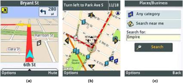
The Telmap application can be downloaded on a wide range of smartphones for a monthly subscription of $4.00, although it isn’t available on low- or mid-range mobile phones because of the absence of GPS. As with most smartphone applications, the mobile phone is still able to receive and make calls while the Telmap software is running. Some detractors point to the fact that carrying out full navigation on a small mobile phone screen is far from ideal, although this is becoming less of an issue as (smartphone) screen sizes gradually increase with subsequent models.
The application allows users to search for information and also send the search results to a friend via SMS (Short Messaging Service, or text messaging). Indeed, Telmap is now heavily focused on building the social networking elements of its application, seeing the potential threat from free-to-use social applications that include location-related search. While this strategy is a logical product extension, it remains to be seen whether it can be successfully executed given the recurrent reluctance of consumers to mix practical and leisure elements within the same mobile application.
What is certain is that Telmap has been consistently profitable from the outset thanks to its premium pricing position, and together with its competitors it has proven that a successful and sustainable business can be built within the mobile LBS sector (albeit business models are subject to rapid change; see section 5.1.4).
Figure 5.1 shows screenshots of Telmap’s mobile solution illustrating (a) the in-car navigation screen, (b) the pedestrian navigation screen, and (c) the search function for local businesses. Now that we’ve considered the premium service offered by Telmap, we can take a look at the competing offer from Nokia, Ovi Maps.
5.1.2. GPS assisted navigation on Nokia handsets—Ovi Maps
Nokia Maps (now rebranded to Ovi Maps, in line with Nokia’s flagship application store) comes preinstalled on most Nokia handsets and displays a number of different points of interest (POI) on top of NAVTEQ maps, such as pharmacies and gas stations, with a high degree of resolution.
Nokia initially offered a number of premium services on top of the free version, including the Traffic Alert service, the Drive service (car navigation), and the City Explorer (pedestrian navigation) service. The City Explorer service reflected a strategic direction by Nokia announced at the Mobile World Congress in 2008 to become a world leader in terms of location-aware services on mobile. Enabling pedestrian turn-by-turn navigation, at a time when this service was not widely available, was but a small element in this strategy, which eventually led to Nokia acquiring mapping giant NAVTEQ of the United States.
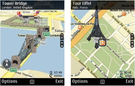
This service allows users to see 3D landmarks (as shown in figure 5.2) and feeds through premium information from Lonely Planet and ViaMichelin to deliver a rich user experience. At €4.50 per year, the service was very affordable but nonetheless had to battle against a number of other free services (including Google Maps for Mobile, which we’ll discuss more later in this chapter).
Figure 5.2. High-resolution 3D views of the Tower Bridge in London and the Eiffel Tower in Paris as depicted by Ovi Maps’ City Explorer service on mobile screens
The Drive service (illustrated in figure 5.3) belongs to the established segment of sat-nav, which had originally sustained premium pricing for a long period of time.
Figure 5.3. An example screenshot of Ovi Maps’ Drive in-car routing on a mobile phone screen providing real time, turn-by-turn navigation using GPS

In May 2009, Nokia announced the release of its Ovi Maps Player application programming interface, allowing third parties to embed Ovi Maps functionality into any website. This ability to synchronize between web and mobile phone could ultimately give Nokia Maps the edge against rivals in its quest for market dominance of location-aware devices. More recently, as a direct result of Google’s shock announcement in October 2009 (see section 5.1.4) to offer a free mobile navigation service, Nokia decided to offer its turn-by-turn navigation services and city guides for free on 10 of Nokia’s phones (including the Nokia N97 mini, Nokia 5800 XpressMusic, and Nokia E72). Plans by Nokia indicate that it will extend the free service to all its handsets in the future.
Now that we’ve looked at two examples of companies offering mobile navigation applications to the end user, we’ll consider an example of a company that started by selling its location platform to mobile operators. To this end, its focus was to foster the developer ecosystem. We’ll see how they did so next.
5.1.3. Creating a navigational widget platform—uLocate
We mentioned uLocate in chapter 1 as having developed an innovative platform for third-party LBSs called WHERE. Its emphasis was wider than just navigation, embracing finding places in general.
By opening up to external developers, uLocate encouraged the creation of dozens of widgets by its community. These were contained within its widget library, shown in figure 5.4. uLocate claimed that a widget could be built in as little as 48 hours by using the company’s ready-made XML tags, encouraging substantial uptake of its platform. These widgets included the following:
- Earthquake finder
- Rent-a-car
- Brewery finder
- Weather status
Figure 5.4. The WHERE widget library, where developers could publish the mobile widgets they built using uLocate’s mobile location platform.

uLocate was in this way able to establish itself as a leading platform for location services in the United States and to encourage the continuous rollout of new applications. The success of uLocate (now rebranded as WHERE) was confirmed by its acquisition by eBay in April 2011 for $75 million.
The Traffic application (shown in figure 5.5) was designed for the iPhone platform and included a number of value-added features, such as these:
- Personalized drives synced with the Traffic.com website to allow users to create customized routes
- Calculations to quickly inform drivers of the severity of traffic delays using real-time data as well as historical speed flow
- Real-time, color-coded traffic flow moving maps built on the NAVTEQ Map TP platform that can be panned or zoomed to quickly view area traffic congestion or set to GPS mode to move along with commuters
- Comprehensive incident data that includes accidents, construction, events, weather, and congestion
- Top traffic hotspots by city or selected roads
Figure 5.5. Screenshot of uLocate’s Traffic application for the iPhone showing traffic hotspots on a typical road route to a user destination in Boston, Massachusetts

It’s not difficult to see how this application will compete head on with those of established navigation providers like Telmap and Ovi Maps, and the need to deliver increased value to the end user will be paramount to hold on to or acquire market share.
This is particularly so as a result of Google’s surprise move to offer free map navigation on its devices running Android. How they did so and the impact it had on some of its competitors is what we’ll consider next.
5.1.4. Google’s (free) Maps Navigation
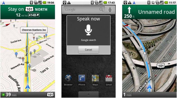
Google shocked the market in October 2009 by announcing a free navigation service for mobile phones that would offer turn-by-turn directions, live traffic updates, and the ability to recognize voice commands (shown in figure 5.6). The service was initially made available on only one phone, the new Motorola Droid, in just one country (the United States, whereas Ovi Maps is available in 74 countries), but expansion to more phones is planned.
Figure 5.6. Screenshots from Google’s Android-based Maps Navigation application, currently free in the United States on a limited number of handsets, including the Motorola Droid
The seismic effect Google can have on the mobile industry was painfully evident to sat-nav pioneer company TomTom, whose share price tumbled over 20% in one day as a result. This is despite the apparent success TomTom achieved in offering a $100 navigation application for the iPhone in August 2009.
Despite the seemingly negative impact on premium mobile sat-nav services like those discussed previously from TeleNav, ultimately Google’s move is in fact confirmation that mobile will be the platform for sat-nav rather than standalone GPS devices. By applying its standard ad-funded business model, however, Google is likely to force competitors to follow suit. Developers should take note, with due allowance made for inclusion of mobile ads within application user interface design and functionality.
Much growth in terms of new startups and new applications within the consumer area of LBS has been in the area of social networks, with the desire by small and big players alike to replicate the explosive growth and success on the web to the mobile sphere. We’ll cover this area next by looking at real examples of five new services launched, each having unique appeal for consumers.
5.2. Connecting with other people or local places
The rollout of GPS and other technologies has made it possible for social networks to add location features, such as friend-finder services, and make it easier for people to stay in touch.
Definition: Personal Area Networks
A location-based mobile social network is different from a normal social network in that it has the ability to determine the user’s location. Some observers refer to these new social networks as personal area networks, borrowing a term from the IT industry.
A comparison of the main features of some well-known iPhone location-based mobile social networks is shown in figure 5.7. We’ve taken an in-depth look at uLocate already in section 5.1.3 and will also examine the diversity between Whrrl and Loopt (as well as others) in sections 5.2.1 through 5.2.5.
Figure 5.7. Comparison of a selection of popular location-based mobile social networks available on iPhone (Source: TechCrunch, 2008)

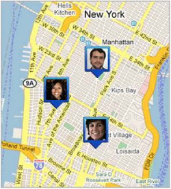
Such location-aware social networks accessible on a mobile platform have generated great buzz in the mobile and web sectors, fueling a tremendous growth in new companies vying for leadership of this niche. Although initially this area was solely populated by new startups, the bigger social networking and social media giants from the web have begun to muscle into the space. Google caused shockwaves in early 2009 by announcing the launch of a killer feature of its Google Maps for Mobile application, Google Latitude. With this service, mobile users with Google Maps installed on their phone (a significant percentage of the market, because Google Maps comes pre-installed on many handsets) would be able to see where their friends are on Google Maps (figure 5.8).
Figure 5.8. Google Latitude screenshot showing the location of three different connected members of the service within the midtown area of Manhattan in New York City
Despite the condemnation of this launch from smaller LBS companies as giving Google an unfair advantage, the take-up of the Latitude service hasn’t been widespread. The service principally centered on being visible to friends and family with no self-evident tangible add-on benefit, and it appears that privacy concerns have prevented significant uptake.
Other social networking giants have also been introducing elements of location to their mobile service, for example, Twitter first allowing a surrogate location to be obtained from the tweet stream of its members and then developing the Twitter Geolocation API to provide more accurate positioning of Twitterers.
Facebook, Twitter, and other major online social networks have now added location to their platforms. (Facebook launched Facebook Places in the United States in mid-2010 and in Europe in December 2010.) The launch of Google’s own foray into social networking, Buzz, in early 2010 (which is designed to be location aware) has no doubt prompted others to follow suit.
We’ll next look at some of the more interesting location-based social networks that have launched since the emergence of these services from a niche to a mass service in the last two to three years. In addition, in the last part of this section, we’ll consider the emerging trend of consumers connecting to local businesses, typically through local promotions or discounts, such as Groupon vouchers.
5.2.1. Creating a story through geotagged photos—Whrrl
Whrrl’s take on the location-aware social networking space has been to focus heavily on the photos taken and uploaded by users at specific locations. Whrrl’s easy-to-browse iPhone interface (shown in figure 5.9) ties pictures sequentially with commentary from the user to create a story of what’s happening at a point in time.
Figure 5.9. Whrrl screenshots of its iPhone application depicting public events happening in the neighborhood and an individual photo story provided by a member of the service

Whrrl (founded by former Amazon employees) originally set out to allow location-based search in 2007 but later specialized within the photo-story segment.
An elegant integration to Facebook and Twitter (both almost indispensable today for any other social network setting up anew) allows users control over who they invite to see their story. Privacy is given more than just a head nod, by making it key to how stories are told, with only trusted friends allowed full access to a user profile.
Another useful feature integrated within the application is a favorite-places function, so that the user can pick from a list of places that he or she has previously visited.
Whrrl’s uniqueness is to make users’ stories turn into a collective mobile journal with multiple points of view on the same experience, which could get really interesting in conference and party settings. Stories also have their own unique URL so they can be shared beyond Whrrl and can even be edited by all participants on the Whrrl website (see figure 5.10).
Figure 5.10. Whrrl’s home screen on its website allows all users to browse through public stories made up of geotagged photos taken by members of the Whrrl community and also to link up with other members who are close to the location of the story.

In 2010, Whrrl changed their concept again (demonstrating the need to continuously adapt to rapid consumer demand) and now allows users to check in to places and unlock societies of like-minded individuals. Whrrl (through its parent company Pelago) was purchased by Groupon Inc. in April 2011, with plans to shut down the service but integrate the Whrrl technology in its own offering.
Now that you’ve seen Whrrl’s take on location-based mobile social networks, we’ll consider one of the early LBS pioneers, Loopt.
5.2.2. Taking location mainstream—Loopt
Loopt can be defined as a mobile social-mapping application allowing users to search for friends and places, with a map as its key user interface, as shown in figure 5.11. Loopt uses location data (from the device itself or the operator network) to display the location of a user’s friends along with their presence status (available, away, and so on). Users are able to send alert requests to their friends when they’re within a certain distance and to tag physical locations.
Figure 5.11. Loopt screenshots of its mobile application showing where users are located on a map, which friends are online, and what messages the Loopt community has been leaving recently in the area of the user

Loopt claims it has over a million users in the United States (the only country where it operates) of mostly people in their mid-twenties and is available across most mobile platforms, from iPhone to Blackberry to non-smartphones from Motorola and other manufacturers.
One of the key strategic elements of Loopt’s growth plan has been to become available on a wide range of mobile operators, so that now every major mobile carrier in the United States offers the Loopt service.
The other key element of Loopt’s strategy has been to build its business model on a subscription fee basis (and less so on advertising), offering one-month free membership and a $3 to $4/month charge thereafter. This changed as other services launched as free-to-use services, and the Loopt is now free (with adverts).
To date, Loopt’s first-mover advantage and substantial financial backing (over $13 million to date) has allowed it to establish itself as one of the best-known LBSs around. It further assisted this by becoming the first (and only) LBS to run a promotional TV campaign in 2008, sponsoring The Middle show.
Both Whrrl and Loopt have played principally to their home market in the United States. GyPSii, on the other hand, has consistently opted for offering its service worldwide. We’ll look at some of the key features of its service next.
5.2.3. Going global with LBS—GyPSii
GyPSii is one of the best-funded non-US-based LBS startups, having obtained over $13 million from investors since launch. From the beginning, it has offered a complete location-based social network application on multiple platforms, from Symbian to iPhone (pictured in figure 5.12).
Figure 5.12. GyPSii latest iPhone home screen showing downtown Amsterdam (Netherlands) and its Places screen showing POIs according to distance from the user and date of last update
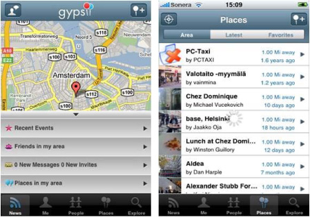
Its application centers on a map through which users can place themselves, find friends or places, and leave geotagged notes and images for other people. Perhaps the main downside of such a technically complete application is that it has proved rather clunky to use, driving the user through series of menus and submenus to access features. In fact, it has mostly drawn a following on the Asian continent, where people are used to viewing more detailed information within mobile applications. Although the company doesn’t release membership numbers or breakdowns, the Asian flavor to the community is clear to most members upon joining. In China in particular, GyPSii has adapted to local market requirements (and legislation concerning the use of GPS) and made a heavy push of its Java-based application.
GyPSii provides a couple of useful lessons to mobile developers who perhaps lack the deep coffers of some of the more established players: first, that a well-designed yet simple app can hold more appeal than a more polished, full-featured one, and second, that the inherent design or look and feel of the app will tend to be more or less attractive to certain demographics. In today’s global economy, this means taking into account likes and tastes by individual continent as well as information obtained through local market research.
Some of the developers of the initial location-aware applications recognized that one of the barriers to adoption was the complexity of using the service. One company set out with a mission to make the easiest-to-use application on the market. This company is called Sniff, and we’ll consider it next.
5.2.4. Making LBS easy—Sniff
Although Sniff’s core service isn’t unique compared to that of the other players in the mobile social networking arena, it was responsible for innovating the charging mechanism for these services. It introduced discreet pricing for a simple action: that of sniffing out your friends, or finding out where they are, by sending an SMS (priced at a premium level).
Sniff originally launched in the United Kingdom and Scandinavia but later launched in the United States as well. It also integrated with the Facebook web application from the outset (figure 5.13), making it one of the more streamlined applications at the time of launch.
Figure 5.13. Sniff’s integration with Facebook has been core to its service since launch, pointing the way for subsequent players in the market.

The way Sniff managed privacy was by requesting that each member allow his or her friends to sniff him or her. It was also possible to set the status to invisible by sending an SMS (once again, at a premium price). The initial novelty of Sniff plus the fact that no special handset was required (because it used location obtained from the cell phone operator) caught the headlines, but the advent of free services that offer something very similar dampened enthusiasm and the service has since shut down.
5.2.5. Real and virtual worlds through LBS—Friendticker
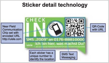
Friendticker was born in Berlin, Germany, out of the desire to use location obtained from LBS applications in a precise manner, rather than relying on the precision tolerances of the various positioning methodologies (see figure 5.14).
Figure 5.14. Friendticker allows members of its community to check in at precise locations and thus place themselves with less than a 1-meter error anywhere in the city. Friendticker defines this new concept as hyperlocalization.

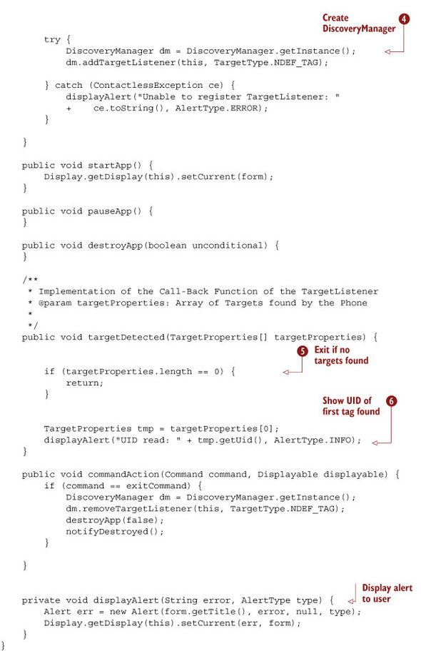
The startup set out to do this in a way that also bridges the gap between the real and the virtual world by using service tags, or location stickers (figure 5.15), that are displayed on shop or restaurant windows. These stickers allow users to check in to a location either by SMS or by scanning a barcode or by using contact-less near field communications (NFC) technology (the overall technology behind NFC, RFID, was covered in chapter 1, where we compared it to GPS technology). Each sticker has a unique number that identifies that location. This enables precise positioning of under 1 meter, clearly unachievable via other methods! An example of the mobile client code (in Java ME) required to read a NFC tag is shown in listing 5.1.[1]
1 Posted by Gerald Madlmayr on Forum Nokia, www.wiki.forum.nokia.com, in June 2010.
Figure 5.15. Friendticker’s stickers are NFC-enabled but also incorporate QR (Quick Response) codes that can be scanned by the handset’s video camera to register the user’s position. In addition, users can send an SMS with a unique numerical identifier for each sticker that tags the user to that location.
Friendticker defines this precise positioning as hyperlocalization; to understand the concept, take the example of groups of colleagues in three adjacent meeting rooms. Through standard location technologies, they’d all be placed in the same place and be unable to interact according to the distinct places where they are. Instead, using hyperlocalization, they’d be able to know when a colleague vacates the adjacent room, for example. Similar scenarios can be envisaged in a large multistory car park or other densely populated environments typical within large cities.
Friendticker thus combines a social network with the ability to interact with the physical world at precise locations. In common with other applications we saw earlier, Friendticker also provides a neat integration with Facebook via a desktop application, allowing a real-time push of location information toward it.
Listing 5.1. JME/Java MIDlet code for reading the UID of an external NFC tag
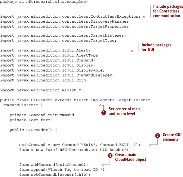
This code example shows how to read the UID of an external NFC tag on an NFC-enabled phone. The main class of the code ![]() first creates the GUI elements
first creates the GUI elements ![]() and then attaches commands to these GUI elements
and then attaches commands to these GUI elements ![]() .
.
When the user activates the command, the code creates the Discovery Manager ![]() and starts the discovery process. If a target isn’t found, the code just returns
and starts the discovery process. If a target isn’t found, the code just returns ![]() ; otherwise, the target is shown to the user
; otherwise, the target is shown to the user ![]() .
.
Interestingly, Google adopted a very similar approach in 2010 by mailing out over 100,000 QR code stickers (shown in figure 5.16) to US businesses, so that consumers could “favorite” certain places. Scanning the QR code with a mobile handset also let users access the review of that particular business. Increasingly, people are also trying out new image recognition technology like Google Goggles (available on Android devices) to leapfrog the QR code-scanning process and obtain the same information (with variable accuracy in the results).
Figure 5.16. Google adopted a similar strategy to that of Friendticker in 2010 by distributing over 100,000 QR stickers to local businesses across the United States in an attempt to bridge the virtual world and the real world.

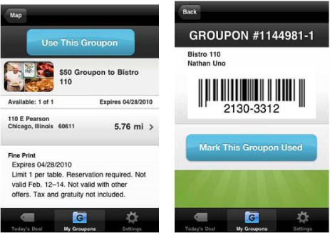
Similarly, Groupon (billed the fastest-growing company in the United States in 2010) took its web strategy one step further by allowing users to download a mobile app (first on the iPhone and then on Android as well) that delivered local “Groupons,” or Group Coupons, with special offers, according to the location of the mobile device (shown in figure 5.17). A Groupon promotion launched in August 2010 for Gap saw close to half a million shoppers opting in for a special $25 discount, even though it was available in downtown Boston for one day only.
Figure 5.17. Groupon’s iPhone application (of which two screenshots are she figure) allows users to find special offers, or Groupons, near their location as detected by the mobile device.
Now that we’ve covered both the practical navigation consumer applications and the social applications, we’ll look at the gaming side of LBS. Though sometimes considered a niche market, increasingly elements of gaming are beginning to find their way into a wider cross-section of applications. The aim of this chapter is to get a flavor for the great breadth of opportunities that exist to meet the needs of the so-called long tail of marketing that was discussed earlier. The success of location-based social networking games additionally proves that initial niches can rapidly convert into mass-market opportunities. We’ll consider this booming area next.
5.3. Entertainment or play
The latest generation of location-based games can be classified into two distinct types:[2]
2 Nicklas, D. et al., “Towards Location-based Games,” Proceedings of the International Conference on Applications and Development of Computer Games in the 21st Century: ADCOG 21 (Hong Kong Special Administrative Region, China, 2001), 61–67.
- Location-aware games
- Spatially aware games
Location-aware games include information about the location of a player in the game. A typical example might be a treasure quest whereby a player must reach a particular location.
Spatially aware games adapt a real-world environment to the game. This creates a connection between the real world and the virtual world. The mobile location-based gaming offering Mobile Hunters belongs to this category of games.
We’ll consider an example of both a location-aware game and a spatially aware one next. One common consideration for both is that they can rely on GPS on some mobile devices, making them battery draining. With the exception of the iPhone version of the games, both require a spare battery pack or separate GPS device.
For existing location-based mobile social networks and especially for newly launched networks, integrating with popular third-party social networks through their public APIs is an imperative. The might of Facebook, with its 500 million global users, and Twitter, with over 80 million, means that English-based services cannot ignore them when developing a new network. As you’ve seen with the previous examples, it’s rare for services to choose not to integrate with the widespread social networks, and if they so choose, to do so at their peril. Facebook Connect, for example, allows developers to integrate their third-party service with Facebook through a set of APIs and so add rich social context to their application.
5.3.1. Creating adventures through location-aware apps—GPS Mission
GPS Mission is a location-aware game, available on JME mobile handsets and the iPhone, that detects the user’s location to load up the available missions in their area (shown in figure 5.18). The game allows users to create their own custom missions by visiting the website directly in the case where there are no available missions nearby.
Figure 5.18. Screenshots of GPS Mission iPhone application illustrating available missions according to the location of the player
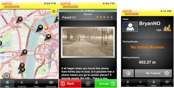
GPS Mission presents the user with the world around them in a Map tab and shows any active missions (which can involve solving riddles at precise locations to obtain points) or “gold” that can be collected in the area (if there’s no active mission to join nearby).
One of the main drawbacks of this game is that missions can’t be created from a mobile device, thus limiting the portability of the gaming notion when outdoors.
Among the game’s cool features is the so-called Activity Stream that lets you see where in the world other GPS missions are being played at any given time, whether a music quiz in Brazil, an athletic challenge in Taiwan, or a photo safari in Australia. In addition, there’s an option to share your gaming experience with others, in real time, and not just within the GPS community but also with all of your friends on Facebook. Finally, with the Waymark function you can leave text and photo messages at any location.
5.3.2. Location-aware treasure hunting—geocaching
Geocaching is a type of high-tech, treasure-hunting, spatially aware game that can be played throughout the world by adventure seekers equipped with GPS devices. The basic idea is to place hidden containers, called geocaches, outdoors and pinpoint their precise location with GPS and then let others hunt for them.[3] Geocaches created by geocaching attempt to combine location-based gaming with a strong sense of community and support for the environment.
3 Jörg Lonthoff and Erich Ortner, “Mobile Location-Based Gaming as Driver for Location-Based Services (LBS) – Exemplified by Mobile Hunters,” Technische Universität Darmstadt, March 2007.
Games are graded according to their difficulty and tend to take place in open countryside environments, as opposed to the urban setting more typical of GPS Mission. Another difference is that real physical objects are contained within the geocaches. Once they’re found, it’s the responsibility of the user to place them back, having first noted an entry in the participant’s physical logbook.
Specific objects can be placed in the geocache, including Geocoins and Travel Bugs, and then tracked as they’re moved by game participants. Overall, the game requires significant skill and often requires users to hunt in challenging places (including underwater!), which has led to the game developing a significant global following.
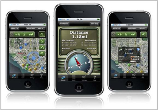
An example of this is the Geocaching application available on the iPhone (see figure 5.19) for $9.99. Some of its key features are the following:
- Searching by current location, address, or geocache code
- Accessing geocache details, including description, recent logs, hints, and inventory
- Looking up trackable item details, including item goals, while on the trail
- Logging geocache finds and posting notes in the field
- Downloading active pocket queries for use while outside network coverage
Figure 5.19. Geocaching iPhone application screenshots, allowing players to navigate within their neighborhood and identify hidden geocaches
Having now covered two examples of gaming pure plays, we can move on to look at an evolution to these that adds the social networking element to the mix. In fact, the success of these new services has been dramatic and has created communities of such size as to compete with established social networks like Facebook.
5.3.3. Location-based social networking games
Given the increasing crowdedness within the mobile social networking space, one way in which companies are looking to diversify is by introducing gaming elements within a standard mobile social networking application. The added benefit is that this gaming element makes the community “stickier” because it encourages repeat visits to check leader boards or improve the ranking of a particular member.
The number of companies in this area (with decent traction in terms of users) is growing rapidly and is outpacing more traditional, pure location-based games.
Three popular services are foursquare, Gowalla, and MyTown.
Gaming Within Mobile Social Networks—Foursquare
Foursquare launched in 2009 with the goal of introducing a gaming element to location-based social networks, principally as a way to gain traction with users in an increasingly competitive area. It had an estimated four million users in 2011. Its application runs on Android, iPhone, and Blackberry devices.
The idea behind foursquare is that users are rewarded for exploring cities. How? Users obtain points every time they check in, or log on to the application. Depending on whether they have checked into a new venue or rarely-visited location, users can obtain a range of different badges to display against their profile (see figure 5.20). If users have checked in to a particular location the most often, they then become “mayor” of that location (or at least until someone else trumps the mayor by surpassing them in terms of check-ins).
Figure 5.20. Foursquare screenshots showing the Check-in button for users, special offers locally available, and the badges that can be won by earning points

Foursquare’s concept of earning points according to the originality of the location means that special Discoverer Bonus points are awarded for checking into a new place. Additional bonus points are also awarded for going to the same place more than once in one night or going out multiple nights in a row.
The foursquare application on the iPhone was recently upgraded to alert members of special offers available to badge holders or mayors, providing a bridge between the real and the virtual worlds. Players can also discover local promotions in real time and get loyalty rewards for regularly frequenting the same place, for example through discount codes for certain products.
A Virtual Monopoly Play—Mytown
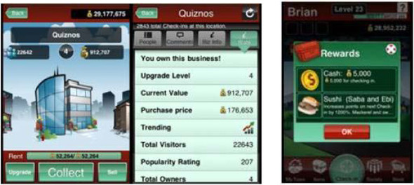
MyTown’s iPhone application (with an estimated 500,000 users in early 2010) is a location-based game, which has successfully differentiated itself from foursquare. Whereas foursquare is about check-ins that revolve around social aspects, MyTown is much more of a straight-up game. In fact, it has been described as a kind of virtual-reality Monopoly.
Although the core idea is still to check in to venues where you happen to be, the driving force behind doing that is to be able to “buy” and develop those properties rather than tell your friends where you are. For example, if you check in at a cafe, you can buy it, and then others who check in there will have to pay you rent. The goal is to accumulate as many properties and as much money as possible. You can also see what venues are trending, as well as their popularity rating based on elements such as number of check-ins.
There’s also a virtual store built into MyTown 2.0 (see figure 5.21). Here, users are able to spend the virtual currency they collect in the game to buy various collectibles. Something else that MyTown is doing that’s more closely aligned with foursquare and Gowalla (see the following section) is real-world promotions. When you check into a venue or near one, you’ll be alerted if a special deal is available nearby. For example, MyTown already has a deal in place with Quiznos for certain rotating specials.
Figure 5.21. MyTown iPhone application screenshots showing the Quiznos location, its location statistics, and user rewards available for checking in at a venue
Now that we’ve looked at MyTown, we can consider a slightly different approach adopted by Gowalla, which obtains its content using crowd sourcing.
MyTown has an in-app purchase element that allows users to buy power-ups within the game that will make it easier for them to play. For example, one power-up allows you to automatically collect rent from your buildings. This is a key part of the game, but without this power-up it has to be done manually, which is time consuming. You can also buy more property slots to allow you to expand your location’s empire, as well as other things. Prices for these in-app purchases currently range from $0.99 all the way up to $9.99.
Gaming with a Crowd-Sourced Twist—Gowalla
Gowalla offers an iPhone application similar to foursquare that you can use to check in and notify friends when you get to a certain location, such as a restaurant or a bar, to earn “pins,” (again, much like the set of badges you try to earn on foursquare). More recently, Gowalla (see figure 5.22) introduced the possibility of clicking a venue and seeing a list of the Top 10 people for that location.
Figure 5.22. Gowalla screenshots showing the user profile (with the number of check-in stamps and pins gained), an example of an item available at a location, and a list of trips available at certain locations

A key difference of Gowalla compared to its peers is that its location-based information is entirely crowd sourced. This has allowed the app to quickly gain traction in places around the world and rapidly build location data (with over 1,000 new locations created per day).
In line with MyTown, Gowalla plans to make virtual goods available as in-app purchases, and a substantial element of its monetization plan relies on this as well as on signing up big-brand advertisers.
We’ve now looked at the key examples within each consumer need area: the need to navigate, the need to connect to other people, and the need to be entertained. This gives us an overview of the three key categories that the majority of location-aware applications can be grouped into. With this under our belts, we can move on to sneak a peek into possible future consumer needs, focusing on those where the user interacts with the compass and video of the handset. Augmented reality applications (and features) that do this are discussed next.
5.4. New app development frontiers
In this section, we’ll look at new possibilities for location-aware app developers that have arisen thanks to the availability of smarter smartphones. We’ll consider specifically the augmented reality (AR) feature capabilities that are possible on the latest handsets, and look at examples of AR applications from acrossair and particularly Layar. Layar (funded by Intel Capital) has set the standard when it comes to AR applications and has generated a great deal of excitement for these types of features. Today, Junaio and Metaio as well as a raft of other AR companies have also joined the fray, though Layar remains the most talked-about service. Before moving on to the Layar example, let’s examine what we mean by augmented reality.
5.4.1. Augmented reality
AR applications began to create a buzz in the mobile location space from mid-2009, as the new handset capabilities (in particular of Android devices) to detect the orientation and tilt of the phone enabled a whole new set of mobile services.
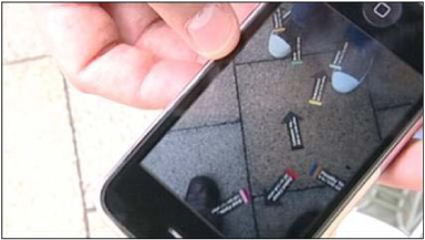
Augmented reality refers to the ability to combine a live or static view of the real world with digital imagery and information, typically shown as a superimposed layer. (See figure 5.23 for a real-life example of the Wikitude application in use.) A famous early example of AR comes from the movie industry. In the 2003 movie Terminator 3, the character played by Arnold Schwarzenegger arrives on Earth naked and uses his AR capabilities to scan human beings for a match or mismatch of clothing sizes.
Figure 5.23. Wikitude was one of the early pioneers in the AR space and launched its AR browser for Android devices in mid-2009 (shown in a real-use scenario). The browser lays Wikipedia and other user-generated content over the camera view of the phone. (Source: mng.bz/qKp5)

Despite the mobile AR area being a nascent area of mobile development, a range of applications and start-ups have sprouted up since Wikitude launched its AR platform and World Browser for Android.
5.4.2. Layar—a pioneer in AR browsing
Layar announced its own AR browser for Android in June 2009 (figures 5.24 and 5.25) and then for the iPhone in 2010 and was followed by acrossair (shown in figure 5.26), which also launched for the iPhone platform. Japanese developer Tonchidot produced an application called the Sekai Camera, combining the AR capabilities with certain features of a social network.
Figure 5.24. Screenshot of Layar’s application for Android that allows users to combine a video camera view of the world with useful information shown as a digital layer on top of the screen view

Figure 5.25. A second screenshot of Layar’s Android application, showing Wikipedia information overlaid on the video camera’s image of downtown New York
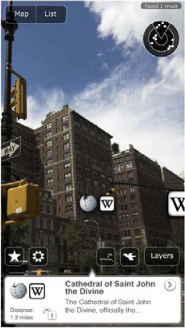
Figure 5.26. Acrossair’s subway finder AR application released in summer 2009 for the iPhone 3GS, one of the first AR apps made available on the iPhone platform
To use Layar, the user holds the phone like a camera and obtains information displayed in real time as a content layer on top of a video view of the surroundings. Layar’s software obtains information from the phone’s GPS, accelerometer, and compass to detect where the user is and which direction they are facing, so as to return information displayed as bubbles with details, including distance from a particular landmark or point of interest.
What current AR applications, such as Layar, do not do is recognize the visual feed obtained from the phone’s camera, instead using location technology to “understand” where the user is and what he’s generally looking at. It is also possible to “cheat” by creating a POI that’s served within an AR layer next to the user independent of where they are. The server code[4] for this example POI coding is shown in the following listing.
4 Kindly provided by Marc Rene Gardeya while quality assurance manager at Layar, 2010.
Listing 5.2. Serving an example POI to a layer within the Layar AR Android application
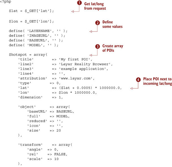

This code example serves a sample POI to a layer for the Layar application. The PHP code first gets the lat and long from
the incoming request ![]() . Then it sets up some constant values
. Then it sets up some constant values ![]() . Next it creates an array
. Next it creates an array ![]() that holds the values of the POI that’s positioned near the incoming lat/long value
that holds the values of the POI that’s positioned near the incoming lat/long value ![]() . Then this is sent back with the JSON encoding
. Then this is sent back with the JSON encoding ![]() and as a JSON string
and as a JSON string ![]() .
.
In figure 5.25 you can see a screenshot of what the augmented world of downtown New York looks like when overlaid with information on specific points of interest obtained from Wikipedia.
Layar (as well as its competitors) offers an API that allows developers to build their own spin-off applications using the Layar browser. The next listing shows a full request/response example for a POI to be shown as part of a layer in Layar.
Listing 5.3. API response using the Layar Android AR browser API
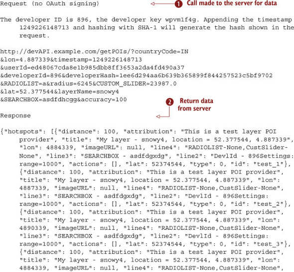
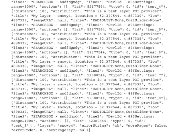
This example shows how to call the Layar API to retrieve points of interest in a given area. When the call is made ![]() , the specific latitude and longitude are passed to the server along with other parameters. Then the server returns all the
POIs near the specified point
, the specific latitude and longitude are passed to the server along with other parameters. Then the server returns all the
POIs near the specified point ![]() , and these POIs are displayed on the map.
, and these POIs are displayed on the map.
Acrossair developed its own specific niche within AR by focusing on subway finder apps designed to help users navigate to the right subway station while still above ground. You can see an example in figure 5.26.
A full description of the Layar API and the APK (Android Package File) with further extensive code examples can be found at http://layar.pbworks.com.
In this last section, we’ve taken a quick glimpse into the future so that you can begin to envision the possibilities of mobile development for location-aware applications. The type of service that Layar launched (and how it was presented) has done a great deal to stimulate demand in the market for new, exciting features in the future. One recent development is that the image captured by the camera is being used to first indentify and then interact with a two-dimensional object. This is used to enhance print adverts and trigger either on-screen animated three-dimensional-looking images or short videos.
In the case of an Android application like Layar, the mobile client will display only the POIs returned that fall within the range specified by the user with the range slider (or, if that slider is absent, within 1500 meters of the user). The distance between the user and the POIs is calculated using APIs provided by the OS of the client. Currently on Android this is the WGS 84 ellipsoid, which might lead to slightly different results than the Haversine Formula (which uses a perfect sphere). The difference is negligible because of the small ranges normally used.
5.5. Summary
The increasing location capabilities of today’s handsets have not only enabled a raft of exciting location-based applications to be offered to consumers but have also meant that mobile has become a pervasive alternative to established navigational aid and PND companies. Although this chapter has treated the different areas of consumer applications as unique blocks covering different needs, from the need to navigate to a place to the need to be entertained, the reality is that functionality is merging across applications so as to offer ever-increasing added value to discerning consumers.
Mobile navigation applications now include elements of social networks and vice versa. Similarly, social networks now include elements of gaming to create user engagement within the communities.
With new handsets now featuring advanced accelerometers and compasses and the general move to smarter handsets, there’s enormous potential to exploit these capabilities and innovate in this area. Augmented reality application developers are just beginning to scratch the surface of the new domain of possibilities, and all of the elements are beginning to slot into place to empower revolutionary, ever-smarter applications.
Navigational aid companies have proved initially successful in establishing profitable businesses by innovating and satisfying market needs. Moves by large players like Google are already altering the established market dynamic. This makes it even more important for developers and entrepreneurs to not only consider how to monetize their applications but also be prepared to innovate how and what they charge for. We’ll examine this area in detail in chapter 8.
You saw in this chapter that a substantial range of features can be built into a location-aware application. We’ve probably only just begun to scratch the surface of what’s possible. However, the complexity of the mobile landscape means that not all application features or services are available in the same way across mobile platforms. This makes it fundamental to understand what the possibilities (as well as limitations) of each mobile platform are.
In the next chapter, we’ll consider which mobile platform options are available to developers according to the type of location feature or location-aware app they’re looking to build.