
Chapter 1. Location-based services: an overview
This chapter covers
- Elements of a location-based service
- Using LBS in the commercial and consumer sectors
- Challenges of developing mobile LBS
- Future opportunities of LBS
Location, location, location!
This common answer to the question “what matters most when buying real estate?” is rapidly becoming the answer to “what matters most in today’s world of mobile services?”
Why is location so important?
Location is a fundamental aspect of the new, exciting world of mobile web-enabled services, revolutionizing how we go about our daily lives. The usefulness of many of today’s most popular mobile applications and services is determined by one key factor: where you are at the exact moment when you’re using the service. Whether you’re checking in to your social network or looking for a pharmacy in the middle of the night, the key is always the same: location. The ability to know where you are and how to get to some place has gone from being a desirable add-on to a mobile phone to becoming an everyday necessity.
This book will explore the exciting world of location-based services and location-aware applications, which were initially promoted by mobile operators to boost mobile usage but which became increasingly demanded by consumers keen to have location on tap. When we talk about location-based services, we’re referring to a wide range of applications and web services designed to work effectively on mobile devices by using some form of positioning or location-based technology.
This chapter aims to introduce you to the fascinating world of location-based services (LBS) and how it’s fast becoming the most important category of mobile applications worldwide. We’ll spend some time considering the wide range of LBS services already in existence today but also take a sneak peek at the exciting developments that are in store for the future. But before we get to all the goodies, you first need to know a little more about what we mean by location-based services.
1.1. What are location-based services?
Let’s start with the basics. Everyone understands the concepts of paper maps, and ever more people know that electronic maps are now available on mobile devices. These initially simple maps have added layers of data, or points of interest, that allow users to see the location of stores, gas stations, and more. In so doing, these maps have become crude location-based services.
Typically you could define a location-based service as an information service, accessible with mobile devices through the mobile network and utilizing the ability to make use of the geographical position of the mobile device.
This definition is out of date in the current generation of mobile and web services (the so-called Web 2.0). Today, user involvement (yes, that means you!) is the name of the game, and an ability to generate content is core to the services or applications provided.
A better definition of an LBS today is a service where
- The user is able to determine their location.
- The information provided is spatially related to the user’s location.
- The user is offered dynamic or two-way interaction with the location information or content.
This way, the user can answer three key questions:
- Where am I?
- What can I do nearby?
- What do I think of this place?
Now that we’ve looked at an updated definition of LBS, we can move on to taking a look at exactly what makes up a location-based service.
1.1.1. Key components of an LBS
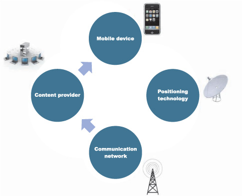
Having covered our bases, we can now look into the individual elements of a location-based service. Four key components are common to all applications: mobile device, content provider, communication network, and positioning component, all of which are shown in figure 1.1. Together, these elements form part of the LBS value chain.
Figure 1.1. Makeup of a location-based service illustrating the four key components required to deliver a fully functional service to the user of the service
We’ll now look at each element in more detail to understand the value that each one brings to LBS.
Mobile Device
The diversity of the mobile device population adds a layer of complexity to LBS application development that has to be properly factored in, especially during the testing phases prior to bringing the service online.
When we talk about mobile devices, we’re specifically referring to an electronic device capable of connecting to a mobile network, via a subscriber identity module (SIM) card, and transferring voice and/or data (making phone calls and downloading electronic maps, for example).
The key opportunity for mobile application developers is that while PC-based location-based services were useful in the home, they couldn’t be taken out and used on the go. This limited their usefulness and confined them to a small group of users. Mobile devices have vastly expanded the market for LBS and made it a highly demanded utility outside the home.
Although the Symbian OS platform remains prominent among the mobile device population, representing roughly half of all handsets, the popularity of smartphones is leading to an increasing number of handsets with competing operating systems such as RIM, Windows Phone 7, Linux, iOS, Android, and Palm webOS, among others.
Smartphones have been of special importance in the rapid uptake of LBS, given their generally large screen size (making maps easily visible) and their almost universal inclusion of positioning technology (such as the Global Positioning System, or GPS).
A more recent phenomenon is the growth of netbooks (9-inch-screen mini-laptops used primarily for web surfing through always-on 3G or Wi-Fi internet connections). These were first launched in 2007, but already 29 million were sold in 2009 (accounting for 40 percent of the laptop market).[1] This, coupled with the possible evolution of the tablet PC (spurred on by Apple’s trumpeted launch in 2010 of the iPad, pictured in figure 1.2), means that developers need to think of a mobile device as something other than a regular mobile phone.
1 “Tablet Computers,” FT.com Lex, January 26, 2010.
Figure 1.2. This iPad is running the Yellow Pages LBS application, currently one of the most downloaded iPad applications in the United States.

What makes location services on connected mobile devices exciting is their ability to move beyond displaying static location data. By refreshing content used by the location app or service on a more-or-less continuous basis, consumers can access a wealth of information at the touch of a button. Next we’ll briefly consider where this content may come from.
Content Provider
A mobile content provider is an entity that creates or owns media (content) that can be provided to mobile devices, either directly or through a third party. The role of content providers has become more and more important with the surge in the number of mobile applications and services available to mobile subscribers. This has led to many application developers and distributors striving for ever-more-compelling content.
LBS providers don’t normally store or maintain all of the content and data that’s being accessed by the user on the mobile device. An obvious example is the mapping data, which is generally provided by one of the major map providers, such as NAVTEQ. Increasingly, the data being accessed is made available to the user as a map layer through third-party content providers, which can be typically switched on or off at the user’s request (displaying gas stations but not pharmacies, for example).
Increasingly, it’s the content that’s offering companies a key differentiating factor between them and competing services in line with the motto that, on mobile, “content is king.” Chapter 4 will cover this area and examine the breadth of content already available through mashups with other web services.
Communication Network
The communication network, on the other hand, is not something a developer of location services can directly control but does comes into play when managing the data traffic used by the LBS service (to maximize transfer speed or minimize latency as well as limit data charges for pay-per-use customers). It’s also a key element to consider for international rollouts of the LBS service (for example, to focus the deployment on geographical areas with later-generation 3G networks).
We can now move on to look at the final element of LBS, the positioning component, vital in that it enables the location part of LBSs.
Positioning Component
When talking about positioning components, we’re typically referring to that bit of technology hidden under the bonnet, so to speak, within a mobile device that keeps track of where the device is. It’s then capable of passing on this location information to applications running on the mobile device itself (so that if you’re viewing a map application, for example, a dot can appear at the exact place where the device is).
Positioning of the device and the ability to determine its location as effectively as possible are clearly essential to all LBSs, which is why we’ll spend some time in chapter 2 looking at these in more detail.
For the moment, it’s worth noting that while positioning components of LBSs are becoming increasingly hidden, even to application developers, as they become an embedded preset feature of many handsets, there still remains a degree of choice between the key methodologies. These include triangulation, Cell ID, satellite navigation, and wireless positioning system (WPS). In those handsets where more than one location technology method is available, hybrid positioning is increasingly used to minimize the disadvantages of single technologies (we’ll touch on these later in this chapter).
Additionally, it’s becoming more common to be able to determine location via an API (application programming interface) or software component to at least fix an approximate location. This is increasingly used by mobile web browsers, for example, to be able to offer search results on mobile websites restricted to the local area the mobile device is in.
Now that we’ve examined the key components of LBS, let’s look back at how LBS has gotten where it is today.
1.2. Today’s commercial and consumer LBSs
The last five years have seen a boom in the number and variety of applications offered to mobile subscribers worldwide. The first generation of mass-market LBSs was those offering some form of emergency response service, capitalizing on the ubiquitous aspect of mobile phones. Subsequent services evolved from giving practical information (where is the nearest gas station?) to focusing more on leisure activities.
Many of the today’s exciting innovations in location-based services relate to consumer services that often include some form of social network or community element. In part, this is because of the explosion of web-based social networking and the logical extension of this phenomenon to the world of mobile.
In reality, commercial or business-to-business services that use location on mobile have been a precursor to current business-to-consumer applications and have established a viable and sustainable business model.
In this section, we’ll examine the successful deployment of LBS applications in mature sectors such as transportation (including how radio frequency identification is likely to further enhance the usefulness of LBS applications here) and progress to some of the newer LBS services now available that are seeking to carve out their own niche in the burgeoning leisure sector.
1.2.1. GPS in the transportation industry
The transportation and logistics industry was worth over $3.5 trillion in 2005, and with global trade on the rise, moving goods will continue to be a big business. No wonder that it has been an area where mobile is aggressively being marketed as a low-cost technological alternative to expensive logistics and tracking systems.
Why invest in expensive, custom-built IT infrastructure, hardware, and software, when the omnipresent phone already has location-tracking capabilities built in? This has been particularly true in emerging economies, where the computer, IT, and telecoms infrastructure has been underdeveloped or expensive to access.
In Thailand and Malaysia, for example, a company called MappointAsia offers such a low-cost alternative using GPS positioning captured via a mobile phone and the GSM mobile network to offer personnel and vehicle tracking, fleet management, and stolen vehicle recovery.
Companies such as US-based TeleNav and Israel-based Telmap have capitalized on the opportunity offered by increasingly sophisticated mobile devices with improved positioning technology to carve out a niche for their navigational software. Both companies offer workforce management, fleet-management tools, and in-car navigation services. We’ll look at these companies in more detail in chapter 5.
1.2.2. GPS compared to RFID
Radio frequency identification (RFID) is a wireless radio technology standard that’s used to describe a system that transmits the identity (in the form of a unique serial number) of an object or person wirelessly, using radio waves. It’s grouped under the broad category of automatic identification technologies.[2]
2 See www.rfid.org.
RFID systems are composed of a transmitting device (referred to as a tag) and a receiving device (the reader). The tag is a relatively simple device that’s capable of sending data to another device. The reading distance of RFID varies from a few centimeters (passive tags) to several hundred meters (active tags). RFID chips can now be miniaturized to as small as 0.05 mm by 0.05 mm and can also be implanted in the human body (an example of an implantable RFID chip is shown in figure 1.3).
Figure 1.3. RFID chips come in all shapes and sizes, including implantable chips that can be used in the healthcare industry to diagnose disease, for example.

A common application is in logistics or for automated toll payment on motorways. The key advantage of RFID over GPS is that the tag doesn’t require a power source nor does RFID require line of sight.
RFID chips in or attached to mobile phones can be used to send data (for example, NTT DOCOMO in Japan deployed the technology to allow subscribers to use the mobile phone as a door key) but not to detect absolute location.
In future commercial LBS applications, a mobile equipped with an RFID chip is likely to be included as part of hybrid location services to be able to locate mobile assets in a wide range of circumstances. In this way, the RFID element will track the asset and the GPS will be able to position it on a map displayed on a mobile phone, rather than a separate (and more costly) tracking device.
1.2.3. Emergency response services
The power of mobile phones to communicate in emergency situations with precise information as to the whereabouts of that emergency can turn them into indispensable tools for emergency assistance and rescue services, for example, when a child goes missing, an elderly relative is alone, or a university student is abducted.
Companies such as Rave Mobile Safety in the United States enable college students to turn phones into personal alarm devices. A student who feels unsafe can activate a timer on the mobile phone that alerts the campus’s security if it isn’t turned off. Should a situation arise, the student is located using GPS.
In the United Kingdom, KidsOK launched a child locator service with similar features to that of Rave Mobile Safety but with extra security features to protect unwanted tracking of children (including on-phone encryption and a parent vetting process).
In Spain, the roadside assistance service RACC launched in 2009 a FindMe service allowing anyone to locate friends and family (who previously gave their consent) by sending an SMS from their mobile phone. Initially conceived in the case of roadside accidents and emergencies, the service is now offered to the public.
1.2.4. Service locator applications
Over the last few years, LBSs have evolved out of the initial core emergency response services to offer simple, practical solutions to everyday life (often related to finding and accessing services or facilities in urban environments).
uLocate, based in Boston, Massachusetts, was at the forefront of this new wave of practical LBS offerings and included a wide range of useful location widgets on its WHERE platform (acquired by eBay), available through major US mobile wireless carriers. These small, simple applications were available by subscription and targeted specific niches.
Notable examples included the Zipcar car-sharing widget, allowing members to locate and view the nearest Zipcars on their mobile screen as well as instantly connect to Zipcar’s reservation system to select a nearby vehicle, and the NearBio widget, enabling users to quickly find the closest biodiesel pumps.
A quick browse on Apple’s iTunes store of iPhone applications reveals that such practical applications have mushroomed (over one-third of the 150,000+ applications in the store are location aware, with many offering practical info, such as Urbanspoon’s restaurant finder).
Both MapQuest Maps and Ovi Maps (formerly Nokia Maps) include rich points of interest (POI) data and map layers that offer a full raft of practical information, from local public transport to local pharmacy listings. Chapter 3 will examine mapping options and map overlays in more detail.
1.2.5. Social networking applications
We live in a world where overconsumption of media and exposure to technological gadgets (including the mobile phone) are such that boredom thresholds are low. Increasingly, mobile consumers are clamoring for their mobile phone to do more for them: to entertain them.
Why else would some of the most successful iPhone applications be one-off quirky offerings, like the shotgun (you got it, it makes the noise of a shotgun) or the cigarette lighter (yes, it comes with a flame).
The so-called internet generation, today’s teenagers, grew up with the web, and the virtual or digital world is a logical extension of who they are. Their digital identity is as important to them as their real identity. It’s only natural that they should expect mobile phones (after all, a key status symbol for them) to allow them to access their digital identity.
Mobile social networks provide the internet generation with just what they need to stay connected with friends all the time. Global web-based social network giants Face-book (United States), MySpace (United States), mixi (Japan), and Cyworld (Korea), with over 600 million members among them, first started offering specific mobile interfaces and applications around 2007 so that members could access a predominantly web-based service.
Also at this time, the first social networks born on mobile (such as Loopt), began to emerge, and typically they linked the network to the location detected by the mobile phone. From 2008/09 onward, within the general move toward an open web, many APIs from leading social networks (led by Facebook’s Connect service) became available. Ta-dah! Suddenly, a much richer user experience was possible for users of location-based social networks, because third-party social networks could be linked up in one giant social graph.
Since then, there’s been an explosion of location-based mobile social networks that emphasize the fun element. This has been on an unprecedented global scale and has rapidly become both the innovation and commercial battleground for location-based service providers and application developers.
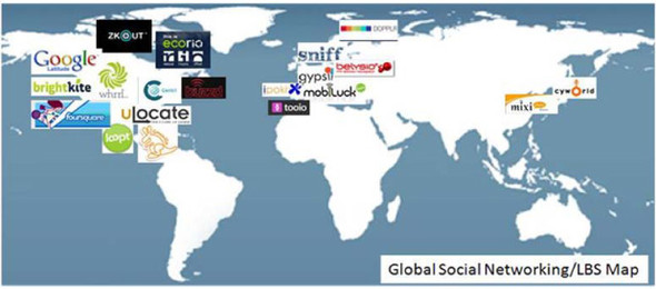
Figure 1.4 displays a number of these services available throughout the world, from small startup operations to more established players. In the developed mobile markets of South Korea and Japan, Cyworld and mixi, launched in 1999 and 2004, respectively, combined have more than 34 million users of their service.
Figure 1.4. Global map of popular location-based mobile social networks across the globe, which have been increasing in popularity and count more than 60 million estimated members in total
Interestingly, companies once focused on practical or commercial LBS such as TeleNav and Telmap (mentioned previously) are now looking to add social network–type features to their services in response to customer demand. This fact points to a degree of convergence that’s likely in the future as the boundaries between different types of service providers blur and offerings join to deliver an integrated experience to the end user.
Now that you’ve had a glimpse of today’s exciting services and innovations in the different areas of LBS, it’s worth taking a look at the challenges you need to meet in order to further extend the reach and appeal of LBS services.
1.3. Challenges of developing mobile LBSs
Making mass-market mobile LBSs that work effectively and universally (meaning independent of mobile operator or country or handset manufacturer) is challenging. If it weren’t so, perhaps prospects for mobile developers working in this field wouldn’t be so interesting.
Developers need to take into account three key challenges when it comes to fostering adoption of their LBS applications:
- Cost of accessing data used by the app via the wireless network
- Handset manufacturers and operators
- Privacy legislation and public perception
1.3.1. Cost of access
More often than not, mobile application developers and startups in the field decide to go after a specific niche or segment, which may be platform related, say, developing exclusively for the iPhone, or geographic, limiting activity to North America, for example.
In fact, the choice of geographic market is more of a key business decision than for many other mobile or even web services because of mobile roaming costs.
Indeed, one of the key challenges still facing developers of mass market mobile applications is to overcome (often prohibitively high) roaming charges for data usage (for data that is used by the application to either secure a location fix or to return dynamic information related to the location). Roaming may not be an issue within a single country, but for apps designed to be used in several countries (like travel apps) roaming charges are a big issue (especially in the European continent, where frontiers are sometimes only a few hundred kilometers apart). There’s a real danger of creating what’s known as “mobile phone bill shock” if the application is intended to be used outside the user’s country of residence. While it’s possible that flat-rate or “all-you-can-eat” mobile data tariffs will become widely available in developed markets, the onus still remains on application developers to reduce data transfer in the case where the end user is being charged on a per-kb-transferred basis.
Even where data roaming charges aren’t an issue, the cost to the consumer for accessing the application has to be set at the right level to encourage mass adoption. Subscription models initially worked best in the case of service locator applications, for example, with consumers happy to pay $3 a month for these practical applications. In the case of social networking applications, free-to-use models that are supported by ad revenues are more the norm. We’ll look at the many options available for embedding adverts in LBS applications as well as the full range of pricing models available for charging for LBS services in chapter 8.
1.3.2. Handset manufacturers and operators
When it comes to mobile handset manufacturers, it’s important to bear in mind that different manufacturers have differing constraints associated with them—some offer more reliable GPS positioning than others, so if an application is being built where this is key, going for these specific manufacturers is essential.
Others will have an open and accessible developer community (the Nokia Forum is a good example of this), such that unanticipated issues can be discussed within a large, open forum.
The availability of higher-end handsets and smartphones with more advanced positioning technologies should also be taken into account. If the intention is to roll out a widely available, mass-market application, then it’s key to develop it on the most widely available platform (JME or Symbian), whereas specific smartphones like the iPhone may be more suitable for premium, niche applications. Also, with the mix of mobile platforms in constant evolution, targeting the right rollout at the right time is essential. Although in early 2008 developing on the Android platform was largely experimental, its momentum is such that nowadays most developers are required to consider dedicating resources to Android.
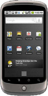
Indeed, Google was ramping up efforts in 2010 to control more of the mobile ecosystem. The launch of the Nexus One (pictured in figure 1.5) attempted to decouple mobile operators from mobile applications. Google experimented selling the phone directly and without the need for a mobile operator contract. This brought the possibility of mobile operators turning into mere data carriers (or dumb pipes, as seen with internet service providers) one step closer. The fact that Google later withdrew the direct sale of the Nexus One (in July 2010), and ultimately all sales of this model, is more an indication of its failure to market the phone than failure of the direct sales model itself.
Figure 1.5. Google’s Nexus One smartphone, launched in January 2010 and featuring the latest version of the Android operating system, marked Google’s attempt to gain greater control of the mobile ecosystem.
Fortunately, the degree to which a mobile operator bears an influence over mobile application development in general is decreasing. Whereas previously getting a mobile application approved to be “on portal” with the mobile operator was the only way to ensure effective distribution, today the “off-portal” model is asserting itself, and consumers are voting with their feet to have applications they like via third-party application distributors or application stores (though lately mobile operators have latched onto the trend and have opened their own application stores). We’ll explore these distribution channels in chapter 11.
1.3.3. Privacy legislation and public perception
Some countries have stringent laws surrounding public privacy (France is one of them) such that a mobile subscriber’s location is protected by several layers of authorization on the operator’s network.
In other countries use of GPS positioning is either illegal for civilian purposes (Libya) or is government controlled (in China, civilian users of GPS have to implement the government’s coordinate-displacing algorithm, so that military targets always appear offset from their true longitude and latitude).
While turning LBSs into a widely adopted and profitable area of mobile communications depends on many factors, undoubtedly one of the key brakes to wider adoption of LBSs is the so-called privacy conundrum.
Consumers need to be protected, and data privacy ranks high among the potential risks to consumers. When that data allows consumers to be located, as opposed to simply having their behavior exposed, a raft of privacy phobias comes to light (never mind that mobile operators know at all times where the mobile subscriber is through the cell signal!).
Consumers fear that white lies may be exposed if their location were public (if you tell your partner you went to the gym but in reality were meeting a bunch of friends, for example). In general, most people are wary of, if not fully opposed to, being tracked by strangers. The paradox arises in that at the same time that users are demanding services that require third parties to have access to private information, they are also fearful of whether this information will be misused.
The gradual introduction of clearer variable privacy settings has allayed some fears by allowing users to decide how accurately they wish their LBS to pinpoint their location. This hasn’t stopped some observers from suggesting that at some point in the future, subscribers will pay a premium to be “dis-connected,” or offline, from a location-aware service.
A consumer backlash against privacy invasions from digital services has given rise to legislation, whose underpinning fundamentals are shared across the United States, Japan, and Europe. These introduce the key element of consent. The EU Directive 2002/58/ EC IV, for instance, states in Article 9 of the that where location data other than traffic data, relating to users or subscribers of public communications networks or publicly available electronic communications services, can be processed, such data may only be processed when they are made anonymous, or with the consent of the users or subscribers to the extent and for the duration necessary for the provision of a value-added service. The service provider must inform the users or subscribers, prior to obtaining their consent, of the type of location data other than traffic data that will be processed, of the purposes and duration of the processing, and whether the data will be transmitted to a third party for the purpose of providing the value-added service. Users or subscribers will be given the possibility to withdraw their consent for the processing of location data other than traffic data at any time.
Today, this means that an opt-in clause is a key requirement in either the development of the LBS application or the service’s modus operandi stated within its privacy policy. It’s essential that developers keep this in mind, because compliance typically takes the form of opt-in screens within the application. In the case of more advanced applications (such as those that adopt “push” mechanisms), it’s likely that both mobile operators and mobile manufacturers have extra rings and hoops through which a developer has to jump in order to publish a compliant application.
We’ll examine these issues more fully in chapter 10.
1.4. Future opportunities of LBS
Location is rapidly becoming a pervasive and ubiquitous component of the next generation of mobile services coming to light, and there’s strong evidence to suggest that commercial opportunities will abound.
If we look first at subscription revenues generated by LBS in 2009 globally, these were $998.3 million, but are projected to reach $6.5 billion in 2013. Advertising on mobile, while an incipient industry, already generated global revenues of $913 million in 2009 and is projected to reach $13 billion by 2013. It is envisaged that a substantial proportion of this expenditure will be contained within location-aware applications. It’s not surprising to see takeovers and consolidation taking place in the mobile advertising sector. Google acquired mobile advertising platform AdMob in November 2009 for $750 million, and Apple bought Quattro Wireless in January 2010 for close to $300 million. In parallel with this, there has been exponential growth in app downloads from the various app stores available. This generated $6.2 billion in 2010 and is expected to reach $21.6 billion by 2013.
Not only will traditional commercial models lead to viable business opportunities, but new pricing models are likely to emerge within the LBS area that will foster growth beyond the boundaries of today.[3]
3 “Mobile Content and Services,” 7th ed., Informa Telecoms & Media, March 2009.
The world of mobile is one of the fastest-moving technology areas in existence today, with growth in mobile handset sales superseding that of traditional PCs. This means that the boundaries are being continuously pushed to the limits, with new handset technology advances delivering additional capabilities to mobile services (the accelerometer on the iPhone, allowing motion and speed to be detected, is but one example).
With so much innovation, and having considered some of the key challenges intrinsic in taking this innovation to the mass market, it’s worth taking a peek at what may lie in store in the near future within the LBS ecosystem.
Location-based services in, say, 2020 will offer a myriad of new functionalities that are difficult to conceive today. By that time, it’s anticipated that the next generation of mobile network infrastructure, or 4G, will have been pervasively rolled out in most developed countries, allowing data transfer speeds over the air many times faster than those available today. More-powerful mobile handsets will bring PC-standard processing power to the pocket that will allow devices to interact with their environment and their owner in brand-new ways.
Much of this interaction will rely on some form of embedded intelligence within the application and/or device so that the context of the user at a certain point in time will allow relevant information or functionality to be automatically pushed out at the right time.
1.4.1. The contextual Holy Grail
Imagine you’re out skiing in the mountains and have your location-based application activated on your phone. Let’s say you want a weather forecast displayed on a map on your phone. An intelligent LBS application will return the forecast but also give you anticipated snow conditions, letting you know if you’ll have powder tomorrow or not.
The application does that because it has some understanding of the context you’re in: you’re connected to the network (your phone is on and you have coverage) and the application knows your location (in the mountains), plus it knows that the season of the year is winter (the context), so it gives you useful ski information.
Figure 1.6 shows the elements of the contextual Holy Grail, namely presence, location, and context, following the example of a skier’s LBS needs from his mobile device.
Figure 1.6. Elements of the contextual Holy Grail in the case of a skier
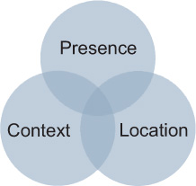
Presence means being connected to the network. Location means that the application knows where you are, and context means that it knows what you may be doing.
This is a basic example of what an application that successfully implemented the contextual Holy Grail is capable of doing. We refer to it in this way because no service is yet able to offer an intelligent solution to make use of a user’s context to push out targeted information. It is in many ways the Holy Grail everyone is looking for. Research into intelligent web technology by Google is underfoot that may provide a powerful mechanism for achieving contextual awareness (or contextual search, as Google defines it). The basic principle is that the mobile device would be able to anticipate (or predict) intelligently what the user is looking for, based on their real-time location and other factors. Google Goggles is a primitive attempt at something related to this, allowing a user to point the device camera and recognize objects, like a beer bottle, and so provide detailed information (like the ingredients, expiry date, and the like).
When it comes to context, time is a basic parameter, which can make applications do things more intelligently. The ability to sense other variables is also being developed. Some mobile phone manufacturers have already launched mobile handsets that are able to monitor the user’s blood pressure and heart rate or monitor the levels of pollutants or pollen in the air.
The future generation of mobile handsets will thus empower a whole new world of intelligent contextually linked services.
For example, say you’re leaving the office after a stressful day at work and have a handset (such as the prototype developed by Nokia in 2008 and shown in figure 1.7) that can monitor your heart rate. Because you’re stressed, your heart rate is higher than normal.
Figure 1.7. Nokia’s Eco Sensor handset prototype with heart rate sensor was also designed to detect pollen levels in the atmosphere and alert allergy sufferers to this environmental hazard.

Walking past an aromatherapy store, a contextually aware location-based application will alert you to the possibility of lowering your heart rate by making use of some of the relaxation products in the store.
This may sound like something from the future-based movie Minority Report, but in fact it’s technically possible today provided the connections among the elements of the contextual Holy Grail are made.
The concept of contextual awareness is linked to that of ambient awareness.[4] Ambient awareness refers to proximity to what other people are doing by picking up little things that they do or the background awareness of what one’s social network is doing.
4 Ambient awareness was a concept developed by researchers at the User Centered Engineering Group of the Industrial Design department at the University of Technology in Eindhoven in the Netherlands in 2004 and remains an ongoing project there.
This relatively new concept is today rapidly becoming a defining feature of new social networks, with the notable example of Twitter. Twitter was founded in 2006 as a way of sharing frequent small messages about what its community is doing and has grown spectacularly to over 75 million users since then.
Twitter gives information on the context of users and so can be used in mobile applications as a surrogate for information directly captured by the handset. Indeed, combining Twitter (mashup) content into mobile applications is rapidly becoming standard for mobile social networks. Since the launch of Twitter’s Geolocation API in November 2009, third-party applications are now able to geotag messages, or tweets, as well as photos (as shown in figure 1.8).
Figure 1.8. Twitter’s release of its Geolocation API in November 2009 allows third-party applications to pull geotagged content directly from Twitter users, making a whole new set of location-aware mashups possible.

Constant innovation in this area means that there are now endless opportunities for the location dimension to be added across a myriad of services.
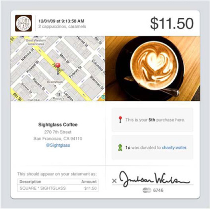
Twitter cofounder Jack Dorsey announced a mobile payment system called Square (see figure 1.9 for a screenshot of how a mobile payment accepted through Square would look on the iPhone) in December 2009, effectively converting a smartphone into a mobile wallet. Location detection is used by the application to show not only the transaction cost but also the exact place where the purchase was made.
Figure 1.9. Square allows anyone with a smartphone and its proprietary add-on device (or dongle) to accept credit card transactions in the same way as a traditional merchant account. The screenshot shows how this electronic payment would appear on the customer’s iPhone.
Chapter 5 will explore a full range of LBS application types and the exciting range of possibilities for developers to innovate by putting location at the heart of mobile services.
1.5. Summary
Location-based services will shape the future of the mobile sector and its current transition from a Web 1.0–type environment to a fully-fledged Web 2.0 interactive, data-rich experience.
There are unlimited opportunities for smart developers and innovative companies to capitalize on both the heightened interest and expectations associated with LBSs and the great advances in handset technology.
The keys to achieving success rely heavily on the ability to clearly define what type of service is to be offered, to whom, and where. This means
- Thinking differently and bravely about how to achieve the contextual Holy Grail
- Optimizing the technical challenges of mobile development, high among which is dealing with a relatively small mobile screen real estate for the majority of users
- Addressing users’ increasing fears regarding privacy of their location
- Choosing the right type of location technology or, increasingly, optimizing the use of a hybrid blend of these technologies
In the next chapter, we’ll take a look at the range of location technologies currently available, both the relatively new (such as Wi-Fi positioning) and the more mature (such as GPS) and how to maximize the usability (and hence chances of success in the marketplace) of a location-based service.