Filled maps fill areas such as countries, states, counties, or ZIP codes to show a location. The color that fills the area can be used to encode values, most often of aggregated measures but sometimes also dimensions. These maps are also called choropleth maps.
Let's say you want to understand sales for Superstore and see whether there are any patterns geographically. You might take an approach similar to the following:
- Navigate to the Sales by State sheet.
- Double-click the State field in the data pane. Tableau automatically creates a geographic visualization using the Latitude (generated), Longitude (generated), and State fields.
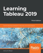
- Drag the Sales field from the data pane and drop it on the Color shelf on the Marks card. Based on the fields and shelves you've used, Tableau has switched the automatic mark type to Map:

The filled map fills each state with a single color to indicate the relative sum of sales for that state. The color legend, now visible in the view, gives the range of values and indicates that the state with the least sales had a total of 3,543 and and the state with the most sales had a total of 1,090,616.
When you look at the number of marks displayed in the bottom status bar, you'll see that it is 49. Careful examination reveals that the marks consist of the lower 48 states and Washington DC; Hawaii and Alaska are not shown. Tableau will only draw a geographic mark, such as a filled state, if it exists in the data and is not excluded by a filter.
Observe that the map does display Canada, Mexico, and other locations not included in the data. These are part of a background image retrieved from an online map service. The state marks are then drawn on top of the background image. We'll look at how you can customize the map and even use other map services in the Mapping Techniques section of Chapter 11, Advanced Visualizations, Techniques, Tips, and Tricks.
Filled maps can work well in interactive dashboards and have quite a bit of aesthetic value. However, certain kinds of analyses are very difficult with filled maps. Unlike other visualization types, where size can be used to communicate facets of the data, the size of a filled geographic region only relates to the geographic size and can make comparisons difficult. For example: which state has the highest sales? You might be tempted to say Texas or California because they appear larger, but would you have guessed Massachusetts? Some locations may be small enough that they won't even show up compared to larger areas. Use filled maps with caution and consider pairing them with other visualizations on dashboards for clear communication.