3
PARTICIPATORY INTEGRATED
WATERSHED MANAGEMENT
Context and rationale
Most NRM interventions in the eastern Africa region tend to focus on farm-level innovations and facilitate change through individualized decision processes. This has left many NRM problems unresolved, including natural resource conflicts, negative transboundary interactions among neighboring farms and villages, absence of collective action (CA) in addressing common concerns, and the degradation of common property resources. AHI sought to address these challenges through methodological innovation at landscape scale. This work was conducted under the conceptual umbrella of participatory integrated watershed management (PIWM). Conceptual evolution of this approach has gone hand in hand with methodological innovations and research findings at site level. An introduction to the conceptual grounding of the approach as interpreted within AHI will clarify reasons for the specific methodological innovations which follow.
Interest in the watershed management approach has increased in recent years in response to water deficits in urban and lower catchment areas (Constantz, 2000; van Horen, 2001), and as a framework for enhancing livelihoods through more efficient and sustainable use of water and other natural resources in rainfed areas and upper catchments (De and Singh, 1999; Shah, 1998; Turton and Farrington, 1998). In recognition of the causal linkage between NRM and poverty reduction and between water and other natural resources (CGIAR, 2002), watershed approaches are gaining in popularity in a host of countries in Africa, Asia and Latin America. The government of India has chosen to invest in rural development through the provision of public finance to communitybased watershed management (Shah, 1998; Turton and Farrington, 1998). Several eastern African governments are considering similar approaches.
Despite this upsurge in interest in watershed management, the large range of projects and approaches falling under this umbrella has led to confusion in goals, lack of consistency in approaches, and limited success in putting the concept into practice (Bellamy et al., 1998; Rhoades, 2000; Shah, 1998). Current practice in the eastern Africa region is biased toward soil and water management for agriculture despite a wide range of NRM concerns among local actors. Approaches for operationalizing watershed management in ways responsive to local NRM concerns and attentive to trade-offs among system components and user groups are therefore sorely needed.
Time–space interactions between plots and common-pool resources, lateral flows of materials (water, nutrients, pests), and interdependence between users in terms of resource access and management, require decision-making and intervention strategies beyond the farm level (Johnson et al., 2001; Knox et al., 2001; Ravnborg and Ashby, 1996). The latter requires effective mechanisms to ensure participation of diverse interest groups and stakeholders, as well as integrated decision-making that acknowledges system linkages (among water, soils, crops, trees, and livestock) and multiple spin-offs from any given intervention. “Participation” and “integration” are two concepts that have helped to ground the conceptual evolution and methodological innovation of watershed management in AHI.
Participatory watershed management may be defined as a process whereby users define problems and priorities, set criteria for sustainable management, evaluate possible solutions, implement programs, and monitor and evaluate impacts (Johnson et al., 2001). Participation implies that broad-based livelihood concerns will guide the watershed management agenda, where water and soil are likely to be only two of many important components. Watershed development is known to work best when there is a perceived deficiency in a vital resource, when integrated with other means of enhancing livelihoods, and when benefits of NRM are localized (Bellamy et al., 1998; Datta and Virgo, 1998; Turton and Farrington, 1998). AHI therefore decided to ground methodological innovations at landscape scale in a systematic assessment of local priorities beyond the farm level, and in mechanisms to unblock pathways from motivation (local concern) to action (solutions) in addressing felt needs. Enabling such processes has meant crafting and testing methodological innovations for ensuring effective representation in decision-making at watershed level; fostering collective contributions to common NRM problems; supporting the negotiation of solutions among groups with divergent interests to minimize the social and environmental costs of current and alternative land uses; equitably monitoring benefits capture; and reformulating by-laws to align the behavior of individuals with collective decisions. While such social and institutional dimensions are part and parcel of participatory integrated watershed management, many of these dimensions are captured in Chapter 4 (“Participatory Landscape Governance”) owing to the depth at which these issues were explored and the scope of lessons learned.
As with the participation concept, integrated watershed management may be understood in a number of ways (German, 2006). As presented in Chapter 1, “component integration” emphasizes the interrelatedness of components and acknowledges the impacts of changes within any given component on other parts of the system. Within the agricultural research paradigm, “system components” are understood to roughly correspond to the boundaries of biophysical disciplines: crops, livestock, trees, and soil. While these components capture much of the “structure” of single plots or farms, they are inadequate for capturing structures and processes at landscape level. While water is present at farm level as a resource for agricultural production, its non-productive function (water for domestic rather than agricultural use) only becomes visible at landscape level. It is at this level where the sum total of management practices on individual plots and farms becomes apparent in terms of the effects on the quality and quantity of water in springs and waterways. Yet the social function of water remains invisible within agricultural research and development institutions, whose institutional mandates are restricted to agricultural production. At landscape level, public and common property resources such as forests, waterways, and communal grazing areas become visible, requiring one to think about more collective decision-making processes. In short, component integration implies moving beyond component-specific objectives (i.e., maximizing the yield of edible plant products) to broader systems goals whereby the relationship between components—as opposed to the individual components alone—becomes a foundation of professional practice. This might include optimizing returns to diverse system components (tree, crop, and livestock) or increasing the yield of any of these components without depleting system nutrients or water. Similarly, the sectoral and constructivist integration concepts featured in watershed-level work in the synergies fostered between social, biophysical and policy innovations on the one hand, and in efforts to systematically identify and integrate diverse interest groups in the innovation process on the other.
The concepts of participation and integration were instrumental to methodological innovation in AHI, and form a conceptual thread that is intricately woven throughout the thinking and methodological interventions presented in the text that follows. Key methodological innovations to be covered in this chapter include methods for landscape-level diagnosis (watershed delineation and characterization, participatory diagnosis and prioritization), planning (at “community” and R&D team levels), participatory management of change, and approaches for putting empirical research at the service of farmers and policy makers to support decision-making. Key knowledge gaps and remaining challenges in methodological innovation for participatory landscape-level innovation are also highlighted.
Watershed delineation
Watershed delineation is the process of defining, identifying, and marking biophysical boundaries to be used for subsequent interventions. Watershed delineation in each site was needed to inscribe both the collection of baseline data on social and biophysical characteristics of the watershed and the eventual innovations to be tested. It was also needed to define stakeholders and to enable future impact assessment of interventions to follow.
While the standard approach is to delineate watersheds on the basis of strict hydrological boundaries, many landscape-level NRM problems involve spatial and temporal processes that have no bearing on hydrology or hydrological boundaries per se. Therefore, the watershed concept employed within AHI has been a flexible one, with a provisional boundary set to guide baseline studies and participatory diagnosis but subsequent flexibility in boundary delineation based on the spatial characteristics of specific challenges to be addressed and the social dynamics therein. Context also matters in the way in which specific landscapelevel NRM problems, such as free grazing, are manifested in the different sites. Therefore, ways in which watersheds were defined vary across AHI benchmark sites. This section describes and discusses the methods and approaches used for watershed delineation, and the relative strengths and weaknesses of each.
Approach development
Approach 1—Hydrological delineation
The approach to delineation employed in Gununo watershed followed most closely the standard approach using strict hydrological boundaries. The output, in the form of a digital elevation model, is presented in Figure 3.1. The potential benefit of the approach is its effectiveness in encompassing the biophysical processes involved in effective soil and water management. Employing hydrological units for watershed delineation can enable soil conservation structures and drainage ways throughout the catchment area to be interconnected, thus minimizing the potential negative effects of isolated conservation structures on neighboring cropland (through their effect in shifting drainage patterns). Furthermore, by taking the catchment as the implementation unit, if all households were to conserve their fields, structures lower on the landscape would be protected from excess run-off from upslope practices. It also facilitates the identification of areas to be targeted for soil and water conservation for optimum returns (in terms of both quality and quantity) to water resources affected by these interventions. Finally, the aggregate effect of structures on water resource recharge can be enhanced. However, this approach also had its weaknesses. Watersheds are not meaningful units for mobilizing collective action, for example. Furthermore, the process of “dissecting” social units (villages, kin, leadership domains) falling within and outside watershed boundaries, can cause resentment among those who were excluded and undermine collective action in addressing common watershed problems.

FIGURE 3.1 Digital elevation model illustrating hydrological boundaries and features of Gununo watershed, Ethiopia
Examples of watershed issues that conform and do not conform to hydrological boundaries are provided in Box 3.1.
BOX 3.1 WATERSHED ISSUES THAT DO AND DO NOT CONFORM TO HYDROLOGICAL BOUNDARIES
“Watershed” issues conforming to hydrological boundaries:
1. Soil erosion and excess run-off. Flows of soil and water across the landscape follow topographical variations within hydrological units, and require collective action within hydrological units to manage upslope–downslope interactions and achieve “aggregate” benefits from enhanced infiltration.
2. Spring degradation. Several causal processes leading to spring degradation conform to hydrological units, including siltation and the effects of tree species selection and forest cover on water quantity and quality, and require collective solutions to manage interlinked landscape processes. The latter include the influence of land use on springs, and consequences of spring protection on lower slopes.
“Watershed” issues that do not conform to hydrological boundaries:
1. Crop and livestock pests. Vertebrate and invertebrate pests wander freely irrespective of hydrological boundaries, with crop pests such as porcupine roaming up to 14 km in a single night.
2. Conflicts over resources in protected areas. While isolation of protected area resources from certain land uses has a direct influence on hydrology through its effects on land use, related conflicts and co-management efforts conform to the spatial dimensions of the protected areas themselves, not watersheds.
3. Free grazing. Conflicts resulting (or opportunities lost) from free grazing have spatial dimensions related to the distribution of grasslands and the administrative units from which grazing households emanate.
Approach 2—Administrative delineation
The second approach, employed by the Lushoto site team, utilized political–administrative boundaries to demarcate the target area. Although the project used the term “watershed” to refer to the area, a hydrological approach to demarcation was not adopted because of the difficulties that would be experienced in community mobilization. Political–administrative boundaries of individual villages were instead considered, with the entire (micro-)watershed encompassing six villages (Figure 3.2).
The use of administrative boundaries in watershed delineation had the important advantage of facilitating the mobilization of watershed residents around issues of collective concern. While the presence of areas within the watershed but falling outside hydrological boundaries may complicate efforts to coordinate soil and water management at landscape level (Box 3.2), this was found to be of minor concern. Other watershed problems having a landscape dimension but not conforming to hydrological boundaries (i.e., free grazing, trees incompatible with crops on farm boundaries, people–park interactions, and pest control) will be less negatively affected by taking administrative boundaries as the basis for “watershed” delineation, provided flexibility is used when determining how many administrative units to involve in addressing the issue. Controlling pests and free grazing at landscape level, for example, requires collective action over a larger area than solving boundary conflicts between adjacent landowners and flexibility is therefore required not only in how boundaries are defined but in the spatial scale over which watershed innovations are organized.

FIGURE 3.2 Baga watershed demarcated using (village) administrative boundaries
Approach 3—“Hybrid” delineation: Hydrological and village boundaries
The major criterion used for the third delineation approach was the hydrological boundary. However, a flexible approach to boundaries was taken to include villages that were dissected by the hydrological boundary, so as to include parts of villages falling outside hydrological boundaries in the delineated watershed. The advantage of this approach is that it accommodates both biophysical and administrative boundaries, which are important for soil and water management, community mobilization, and addressing landscape-level problems whose spatial dimensions extend beyond the hydrological boundaries of the watershed. The disadvantage of this approach is that delineation of the target area tends to be subjective, lacking strict criteria to include or exclude different areas. Ultimately, delineation becomes an art rather than a science, which must be flexibly adapted to emerging challenges and the spatial scale over which these are manifest both socially and physically (Box 3.3).
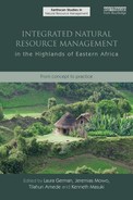
Approaches used for watershed delineation in AHI benchmark sites are summarized in Table 3.1.
BOX 3.2 THE IMPORTANCE OF A FLEXIBLE CONCEPT OF WATERSHED BOUNDARIES
Limited coverage of areas lying outside the hydrological boundary of the watershed can hinder implementation for either social or biophysical reasons. Figure 3.3 below illustrates two adjacent watersheds (A and C). B is an area hydrologically part of watershed C, but included as part of watershed A during watershed delineation. This is because the support of local institutions and local government residing in area B are crucial for the effective implementation of watershed innovations in area A. At the same time, construction of soil erosion and run-off controlling measures in area B will not be effective unless the upstream part of watershed C is treated. Depending on topography, run-off generated from the upper part of watershed C could also destroy soil conservation structures in area B unless also treated. There may therefore be a need to expand certain watershed interventions among landowners in watershed C so as to improve the effectiveness of soil conservation interventions in area B.

FIGURE 3.3 Relationships between adjacent watershed units and the need for a flexible interpretation of watershed boundaries
TABLE 3.1 Delineation approaches used by different benchmark sites
BOX 3.3 MANAGING HYDROLOGICAL AND ADMINISTRATIVE BOUNDARIES: BIOPHYSICAL AND SOCIAL “BALANCING ACTS”
Case 1—Biophysical balancing acts
Watershed boundaries are generally set according to hydrological processes and units, with a focus on soil and water conservation. When taking a participatory approach to watershed management, however, other types of biophysical issues emerge that are not readily inscribed by hydrological boundaries. Negative effects of free grazing such as crop destruction and constraints to agricultural intensification are examples. Multiple tenure systems that overlap in time and space define the movement of livestock in Galessa watershed. While all land is publicly owned in Ethiopia, in practice all cropland is allocated to individual households. During the cropping season, a household's livestock may only graze in “private” outfields owned by them and a small group of adjacent households which lie fallow (restricted access grazing). During the dry season, however, after all crops are harvested, outfields are managed as open-access resources and any given household can graze their livestock anywhere inside or outside of the watershed. No rules govern livestock movement on one's own fields, and freely roaming livestock come from villages inside and outside the watershed. Efforts to intensify outfields through integrated interventions (soil conservation structures, high-value multi-purpose trees, or perennial crops) must involve decisions by all outfield users to restrict livestock movement, which would otherwise destroy technological innovations. Outfield intensification and free grazing are therefore “watershed” or “landscape” issues whose boundaries and solutions extend far beyond the arbitrary confines of the watershed.
Case 2—Social balancing acts
Another form of balancing act relating to watershed boundaries involves human motivations to participate or “opt out” of any innovation. Two cases help to illustrate this dynamic. In Ginchi, spring development and value addition through a shift from ware to seed potato were very popular interventions among watershed residents. The watershed falls inside larger administrative units (Peasant Associations—PAs) which were not fully covered by these activities. When watershed meetings were called, PA leaders residing outside the watershed held mandatory meetings on the same days to “sabotage” watershed activities as a form of protest for their non-inclusion. The team therefore had to expand membership in some activities to adjacent villages as a means of managing the social challenges faced.
The second case comes from Kapchorwa, where four villages were involved in watershed management activities. Free grazing came up as an issue of concern to them. However, managing this problem required curtailing access to communal areas for their own livestock as well as for non-participating villages. Non-participant households were in effect asked to participate in an activity with detrimental effects to their livelihood without otherwise benefiting from other watershed activities bringing concrete benefits, and therefore had no incentive to engage in collective action. The team was therefore challenged to come up with innovative ways to include them in a broader set of activities, so as to foster a stronger collaborative spirit among watershed villages. A two-pronged strategy was adopted: to seek technological alternatives (i.e., alternative feed) to minimize the costs of cutailing free grazing, and to invite these households into other watershed management activities bringing more concrete benefits.
Lessons learned
The following lessons may be distilled from the application of different approaches and their consequences for subsequent stages of implementation:
• Delineation together with local leaders enabled both parties to take cognizance of the landscape dimensions of NRM problems and the magnitude of degradation experienced in watershed villages, and heightened local ownership in the activities to come.
• It is difficult to strictly follow hydrological boundaries in delineating watersheds. Delineation may be carried out on the basis of social dynamics, administrative boundaries, hydrological boundaries, boundaries of landscape-level NRM problems that do not conform to hydrological boundaries, or a combination of factors. When employing combined criteria, it is possible for delineation to accommodate both biophysical and social processes, thus facilitating implementation.
• It is important to let the context—in terms of the specific dimensions of landscape-level NRM problems found within each particular site or niche—determine how flexibility in boundary definition will be defined. This implies keeping a flexible definition of boundaries during planning and implementation stages to ensure that the spatial dimensions of identified problems are considered in the intervention area.
• Regardless of whether the “watershed” is delineated according to administrative or biophysical criteria (or both), the boundaries of any given intervention should be kept flexible to accommodate social or biophysical influences from outside the pilot area and to enable them to be adapted to the spatial configurations of issues subsequently identified during planning and implementation.
Watershed characterization
During watershed characterization, biophysical and socio-economic baseline data is collected prior to intervention to enable R&D teams and communities to measure progress during implementation, and to identify socio-economic and environmental “hotspots” and opportunities for intervention. Collection of baseline data is crucial for organizations specializing in methodological innovation such as AHI, as it facilitates subsequent assessment of impacts from diverse innovations.
Approach development
Socio-economic aspects of watershed characterization
Household surveys using pre-tested questionnaires were carried out with a representative number of households in AHI watersheds to gather basic information on the five capital assets (human, social, natural, physical, and financial capital), and on household livelihood portfolios and related constraints. Households were selected using purposive sampling techniques based on household wealth status, as determined through standard participatory wealth ranking methods (Rietbergen-McCracken and Narayan, 1998). For a summary of data collected, see Box 3.4.
BOX 3.4 DATA COLLECTED IN HOUSEHOLD SURVEYS IN AHI BENCHMARK SITES
Human capital
• Household demographics (family size, gender, age, education, labor force, disability)
• Awareness of soil erosion and other NRM challenges
Social capital
• Conflict resolution mechanisms
• Perceived importance, levels of enforcement and effectiveness of different by-laws in solving identified watershed problems; awareness of by-law formulation processes
• Significance of and access to resources through kin relations
• Membership and role within local institutions, and benefits derived from the same
• Importance of different local institutions, and degree to which they help meet livelihood objectives
• Barriers to, and willingness to invest in, diverse collective action institutions and activities
• Coping strategies (sources of assistance) and assistance given to others during financial crises
Natural capital
• Distance to seasonal and year-round potable water sources
• Source of potable water, and observed changes in springs/rivers over time
• Landholdings (size, number of plots, soil quality, landscape location, conserved land) and perceived tenure security
• Access to irrigation water
• Livestock holdings (number, type, and breed)
• Trees and woodlots (species and area), and changes in tree diversity/cover over time
• Common property resource access (grazing land, forest products)
• Changes in farming system, yields, and productivity over time
• Energy access/use
Financial capital
• Income from different sources (crops, livestock, trees, and off-farm)
• Household investments in order of importance
• Changes in income sources and investments over time
• Loans received and sources
Physical capital
• Levels of adoption of different introduced technologies
• Housing, sanitation
• Tools, equipment, livestock structures
• Transportation and communication
Livelihood portfolios and constraints
• Major constraints to improved livelihoods and agricultural production
• Most important crops/on-farm activities in household livelihood portfolios
• Crop/livestock pests and diseases most affecting livelihoods
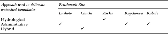
Wealth- and gender-disaggregated analysis facilitated the identification of enterprises and constraints common to different groups. In most sites, R&D teams also identified and characterized local institutions that either currently influence NRM or might play a role in NRM in the future. Local institutions were given an important consideration during characterization of the watershed because they were assumed to be important for community mobilization and technology dissemination. The characterization also involved an identification of diverse types of institutions, from formal groups to local norms and by-laws, traditional beliefs influencing NRM and influential leaders. The description of each institution included its function, its influence on community well-being, how respected it is by different social groups (by gender, wealth, and age), and its possible role in NRM. Identified institutions, classified according to their functions, are summarized in Table 3.2 (see also Mowo et al., 2006 for details).
TABLE 3.2 Local institutions in Areka, Ginchi and Lushoto benchmark sites
Type of institution |
Lushoto site |
Ginchi site |
Areka site |
Faith-based |
Church groups, Mosque groups, traditional healers |
Mahiber and Senbete (Orthodox followers), Jabir / Jarssuma |
Mahiber and Senbete (Orthodox followers) |
Financial |
Rotational credit associations |
Edir, Ek’ub |
Edir, Ek’ub, Meskel Banking |
Agricultural |
Rotational livestock associations |
Ribi, Sharecropping, Contracting |
Hara, Kota, Sharecropping, Contracting |
Collective action for heavy tasks |
Ngemo |
Debo |
Debo, Zaye |
Other |
|
Quallu |
|
TABLE 3.3 Local institutions most linked to livelihood goals by wealth category (German et al., 2008)
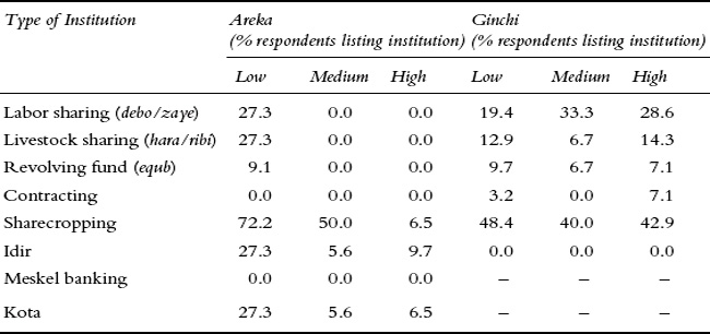
To understand which institutions were most valued for their social or economic functions, and therefore most likely to be effective in mobilizing collective action, interviewees were asked during household surveys which institutions “are most valued” or “contribute most to livelihood goals.” From our experience, answers to the two questions were very different so they provided complementary information. Outputs for the second question are summarized in Table 3.3 for two Ethiopian sites. Results show the fundamental importance of shareholding to livelihoods, particularly for low-income households.
Biophysical aspects of watershed characterization
The biophysical characterization involved land resources assessment, including soil, water, vegetation, and types of crops grown. Local soil classes were identified using local knowledge and indicators across sites. To complement the local soil classification system, the FAO soil classification system (FAO-UNESCO, 1987) was used for one village in Lushoto and results extrapolated to other villages with similar soils. Water resources were characterized according to location and degradation status through the use of global positioning systems (GPS), ethno-historical accounts and physical observation. Participatory mapping techniques were employed to identify key land uses and the location of environmental “hot spots” or highly degraded areas. Aerial photos, topographical maps and satellite images were used to develop preliminary land-use maps and/or digital elevation models (DEMs). Outputs of these techniques included geo-referenced watershed maps (Figures 3.1 and 3.2, shown earlier), land-use types and their spatial extent, water resources location and status, slope classes (where DEMs were generated), and the location of highly degraded areas. Table 3.4 summarizes the methods used for watershed characterization in different sites. While water source characterization was not carried out during the watershed characterization phase in Ginchi and Areka, it was later included following the participatory diagnosis of watershed problems given the high priority of water quantity and quality to watershed residents in all sites. Soil classification was only carried out in Lushoto given the presence of a PhD student hosted by AHI and the expense associated with doing so in other sites.
TABLE 3.4 Watershed characterization and baseline methods used in different sites
Scope and methods of watershed characterization |
Benchmark Sitea |
||
|
Lushoto |
Ginchi |
Areka |
Social: |
|
|
|
• Semi-structured questionnaires |
|
|
|
• Participatory evaluation of local institutions |
|
|
|
Biophysical: |
|
|
|
• GPS readings |
|
|
|
• Aerial photos and satellite images |
|
|
|
• Digital Elevation Model |
|
|
|
• Water resource characterization |
|
|
|
• Soil classification using FAO system |
|
|
|
• Assessment of land use types |
|
( |
( |
• Participatory mapping |
|
|
|
Notes:
a These characterization methods were not conducted in Kabale or Kapchorwa owing to the diversity in approaches being tested, donor funding and related commitments, and the stronger development orientation of partners.
b Parentheses are used where the method was applied but with less detail (i.e., percentage coverage of each land use type was not assessed).
It is important to consider how data are to be utilized once collected, so that watershed characterization does not remain a purely academic exercise. One such use is to gather baseline data for subsequent impact assessments. In this case, data should explicitly focus on variables or parameters expected to change—whether biophysical (productivity, biodiversity, hydrology), social (prevalence of conflict and cooperation), institutional (attitudes and practices of researchers and extension agents) or economic (household income and investments). Another use is for the effective targeting of interventions. This targeting may also cut across diverse areas of impact. Economic data may help to target interventions to address the production strategies of different households. Table 3.5, for example, provides an indication of the crop preferences of households from different wealth categories across the Baga watershed. This table suggests that support for the production and marketing of tomato, pepper, and potato are likely to have implications for a broad cross-section of the population. However, to improve the status of lower income groups, a focus on cabbage and banana (a crop with lower investment costs) may be warranted.
TABLE 3.5 Average income from selected crops by wealth category in Baga watershed, Tanzania (Tsh)

TABLE 3.6 Standard deviation (SD) in household income from selected crops in Baga watershed

Looking solely at income averages may, however, be deceptive in assessing whether all villages and the poorest households will benefit from technologies that are highly dependent on access to prime cropland, such as valley bottoms. In the case of the highest value crops (tea, tomato, cabbage, pepper), standard deviations are significant—illustrating the high variability in income sources among households within any wealth category (Table 3.6). Targeting interventions to different households may therefore require understanding not only the most important income earners in the aggregate, but also key income earners for the poorest households.
Priority areas of intervention may also be derived from data on environmental “hot spots” or areas of extreme degradation. A participatory mapping exercise combined with detailed field observations helped to identify priority areas for intervention at watershed and village levels (see Plates 3 and 4).
Lessons learned
The diversity of approaches utilized and the extent to which collected information was utilized in subsequent stages enabled lessons to be learned on the characterization process, including the extent to which AHI approaches have added value to standard methods and procedures used in watershed characterization. These include the following:
• The need to balance costs and benefits of watershed characterization. While the integration of diverse methods has the potential to generate important data on the integrated nature of problems and their solutions, and to facilitate proper targeting of technological, social, and policy interventions, comprehensive characterization work requires time and resources and may generate fatigue within watershed communities. Therefore, characterization work must be justified by program requirements (e.g., baseline data for subsequent impact assessments), additionality (e.g., inability to solicit the same information through participatory techniques) and balanced by the need to effectively capture farmer enthusiasm at early stages of any watershed management initiative.
• The importance of an iterative approach to watershed characterization. Collection of voluminous data on the watershed prior to participatory diagnosis of problems of concern to local residents may represent an inefficient use of resources. A basic understanding of watershed boundaries and features is often sufficient at this phase, provided this is followed up with a more in-depth characterization of problems prioritized by watershed residents for intervention.
• The importance of considering social variables in watershed characterization. Research on variables such as local institutions, traditional beliefs and norms in NRM, and how residents rank local leadership (traditional, political, religious, and opinion leaders) may provide important information on the best means to mobilize the community for different types of activities. Including questions such as willingness to participate in collective action for different watershed activities, perceived land tenure security for different ecological niches, perceptions on the status of common property resources (e.g., rangelands, forests), and forms of social capital most essential to the livelihoods of different groups also provide important insights into watershed problems and solutions.
• The value of farmer participation in social and biophysical characterization, which can enhance understanding by the research team of important problems and opportunities to be captured within intervention strategies.
Participatory watershed diagnosis and planning
When agricultural research organizations have taken an interest in watershed management, the approaches used often place undue emphasis on soil and water conservation without integrating livelihood concerns and other priority landscapelevel NRM challenges (e.g., crop destruction from free grazing, competition of fast-growing trees with springs and crops, or water resource degradation). Other NRM investments seek to maximize returns from specific components (trees, crops, livestock, or water) rather than from integrated interventions designed to bring multiple returns and synergies, and disseminate technologies in isolation from complementary social and policy interventions. Furthermore, research organizations tend to plan in isolation from local government, community-based organizations (CBOs), and NGOs. While some development agencies have evolved much more integrated approaches to NRM, common deficiencies remain in ensuring that diverse local ‘voices’ are effectively captured during planning processes.
Approaches used in AHI have attempted to overcome these limitations in a number of ways. First, collective and negotiated decision-making became part and parcel of watershed planning. Disaggregated watershed diagnosis and prioritization strategies were also tested in some sites as a means to identify approaches effective in capturing diverse or divergent perspectives. While there is still much to learn, we also strove to develop more integrated approaches to planning to address a wider range of issues through collective action and identify opportunities for fostering synergies between different system components (trees, crops, water, soil, livestock) and strategies (social, technological, policy, and marketing). Some planning strategies were also unique in fostering partnerships among complementary institutions—and in bridging institutional gaps between research and development agencies, different sectors (i.e., agriculture and water), and among agencies with livelihood and conservation mandates.
Approach development
Four different strategies for participatory watershed diagnosis and prioritization were tested in AHI benchmark sites. These are described in detail below along with their relative strengths and weaknesses.
Approach 1—Demand-driven approach to diagnosis and stakeholder engagement
This approach focused on enabling community members residing in a watershed area to articulate their concerns and to demand broader stakeholder engagement in support of subsequent actions. The approach consisted of the following steps:
1. Identify emerging leaders concerned about landscape or “watershed”-level NRM problems.
2. Carry out village-level meetings in all watershed villages to identify problems affecting farmers and their livelihoods in the watershed and prioritize the most urgent issues to be addressed.
3. Task villages with the formation of Village Watershed Committees (VWC) (see Plate 5).
4. Task villages with the selection of members from VWCs to serve on higher-level Parish Watershed Committees.
5. Task the Parish Watershed Committees to call a meeting with all VWCs; Local Councilors from village, parish and sub-county levels; the Local Council Chairperson from sub-county level; local opinion leaders; and staff from relevant line ministries to map the watershed and assist the community in articulating demand for support from relevant actors.
6. Carry out a field visit with technical staff from district line ministries and Watershed Committees to the areas most affected by urgent NRM problems (i.e., excess run-off, landslides).
7. Hold meetings with Village Watershed Committees and technical staff to develop provisional work plans.
8. Conduct technical assessments of the areas most affected in each village with Village Watershed Committees to map the watershed and identify hotspots associated with key NRM problems.
9. Hold meetings at watershed level involving all stakeholders (including all watershed residents) to give feedback on the draft work plans and technical recommendations on ways to address priority problems, and harmonize the two work plans.
This approach enabled the community to own and fully participate in the process of planning and implementation, while also consolidating the commitment of other development agencies to support communities in collectively addressing their priority concerns.
Approach 2—Watershed entry through local leadership and local NRM structures
The second approach entailed working through established leadership structures and existing local NRM institutions with a history of involvement with development agencies to inculcate responsibility on their behalf for mobilizing communities for improved NRM. The steps in this approach included the following:
1. Hold district-level meeting with representatives of targeted sub-counties (in this case, Sub-County Chiefs, Secretaries for Production, Farmer Fora Chairpersons, National Agricultural Advisory Services (NAADS) Coordinators, and concerned farmers from villages in each sub-county) to build commitment, empower them with facilitation skills and generate a general strategy for supporting participatory NRM in their sub-counties.
2. Hold meetings at sub-county level to consolidate NRM institutions and initiatives in the sub-county through:
a) Election of members of sub-county NRM committees by sub-county representatives participating in the above meeting, Local Council representatives from village level, and farmers with an active commitment to NRM.1
b) Selection of priority areas for project intervention based on villages experiencing severe degradation or demonstrating the most commitment to NRM.
c) Establishment of a schedule for monthly review and planning meetings by these newly constituted committees to evaluate progress on NRM strategies.
d) Appointment of core teams from the sub-county committees to spearhead sensitization and the formation of other committees in each target village.
3. Task the core teams to mobilize village meetings for the purpose of sensitizing all village members on NRM and encouraging them to elect members of village-level NRM committees. During these meetings, each village identifies the major NRM challenges that have caused widespread misunderstanding or conflict at village level, and prioritizes the most pressing challenges that the project can help them address collectively.
4. Hold a series of meetings in each village to orient newly constituted village committees on their roles and responsibilities in NRM. This is done through joint reflection on what is required from them (their envisaged roles) to support their respective villages in mobilizing collective action to address previously identified priorities. Identified responsibilities may include awareness creation, mobilizing local residents to formulate NRM by-laws, the selection of demonstration sites within identified environmental hotspots, and conducting training needs assessments. These are then integrated into Natural Resource Management Planning Committee (NRMPC) work plans in support of village-level collective action.2
5. Hold joint meetings between village NRM committees and local government structures to enable a participatory process of by-law formulation to address identified watershed problems (Box 3.5), and to aid in compliance and enforcement of agreed responsibilities.
This approach builds the capacity of local government in supporting communities and ably fulfilling their responsibilities toward their constituents. It also builds the capacity of local institutions in articulating and addressing local concerns.
BOX 3.5 REFORMULATED AND HARMONIZED BY-LAWS IN RUBAYA SUB-COUNTYa
Soil and water conservation:
• Everyone shall dig water trenches (soil erosion structures) especially on hillsides in their own land prior to any cultivation. Anyone who violates the above by-law will be liable to a fine, which will be decided by the sub-county (LC3) council, in collaboration with representatives of policy task forces (PTFs).
• Napier/Elephant grass and other grasses (and/or trees) shall be planted in landscapes where water trenches are not feasible, such as in very rocky or rugged terrain.
• Every farmer should consult neighboring landowners prior to breaking down the terrace or contour bund along the common land demarcations or borders.
• No one shall cultivate his/her land without digging water trenches and planting trees and grasses, to conserve soil and water in their own land.
• Prior to cultivating, everyone should excavate trenches and construct steps and “A” frames.
Those who violate these by-laws shall be fined Sh. 5,000; or else they will be forwarded to the LC3 council authorities for punishment.
Grazing:
• No one shall graze in the valley bottoms, irrespective of whether or not the land is one's own.
• Everyone shall graze in his/her own land, and if not, seek permission to graze in others’ land. Any abandoned land—including hill tops—should be utilized for growing agroforestry trees.
• No one is allowed to come from another country and graze in Uganda. [Ref: Rwanda].
Those who violate these by-laws will be fined Sh. 10,000.
Water:
• Everyone who draws water from a communal water source or well shall cooperate with others in its cleaning or maintenance.
• Anyone utilizing land near a communal well, road, foot path or water trench, should reserve a stretch of 1–2 meters of uncultivated land between their land and the said communal structures.
• No one is allowed to graze or cultivate near water sources/wells, or wash clothes from them.
Those who violate this by-law will be fined Sh. 5,000.
Other:
• Burning of grasses, hillsides, weeds and trees is strictly prohibited (Those who violate this by-law will be fined Sh. 10,000).
• When cultivating, leave some reserve narrow strips of land along boundaries, roadsides, livestock tracks, etc. (Those who violate this by-law will be fined Sh. 5,000).
• Whoever cuts down trees shall plant replacement trees (Those who violate this by-law will be fined Sh. 5,000).
• Every household shall cultivate fruits, such as avocados (Those who violate this by-law will be fined Sh. 5,000).
• Anyone who owns or rents land in another village should abide by the NRM by-laws obtaining in that village.
Note:
Village policy task forces (PTFs) should have representatives at LC3 (sub-county) level.
Approach 3—Socially-optimal watershed diagnosis to capture diverse “voices”
The third approach consisted of systematically capturing the perspectives of diverse social groups within the watershed, first through socially disaggregated focus group discussions and next through household surveys in which representatives of these different groups were purposively targeted. The approach consisted of the following key steps:
1. Contact local leaders to inform them of the project mandate and interest in supporting livelihoods and NRM in their areas of jurisdiction.
2. font-size: 100%;Conduct focus group discussions in each watershed village according to social categories likely to influence people's priorities in NRM, namely by gender, age, wealth, and landscape location (farmers with households and plots upslope and downslope, where relevant).3 The following set of questions can be used as a guide for eliciting watershed problems:
a) How have changes in the landscape and land use over time influenced your livelihood?
b) Do your neighbors’ on-farm management practices have any influence on your livelihood? How about the management of resources by neighboring communities?
c) Are there any NRM problems that could benefit from collective action?
d) Are there any problems associated with communal resources?
e) Are there any conflicts associated with land or natural resource management (within or between villages)?
Local leaders are singled out during this process and their views obtained through key informant interviews.
3. Generate a single list of identified watershed issues for the whole watershed.
4. Conduct participatory ranking of these issues according to disaggregated social categories (again, by gender, age, wealth, and landscape location), either in focus groups or through interviewing key informants from each village—ensuring that views are captured equally across all social categories.4
5. Analyze data in the office to generate average ranks by village, gender, age, wealth and—where relevant—landscape location, and highlight watershed issues of high priority across all social categories (Table 3.7).
6. Identify entry points based on Step 5, with attention to those key priorities that can bring the most immediate benefits to a majority of watershed residents to heighten their enthusiasm for future watershed innovations (Box 3.6).
7. Conduct a one-week planning session for research and development teams to explore the causal interactions among identified watershed themes and generate clusters of issues to be addressed through integrated solutions.5 If research is to be conducted together with development interventions, research topics and protocols are also generated at this time.
8. Conduct participatory watershed planning involving all watershed residents. The process involves the following steps:
a) Feedback of issues identified by the community, how they were prioritized differently by different social groups, which issues are ranked highly by all watershed residents.
b) Presentation and discussion of constituted watershed “clusters,” and the logic underpinning these groups.
Note: In some sites, the teams subjected these ranks to community scrutiny and priorities emerging from socially disaggregated ranking caused issues of high priority by some groups to be subsumed in importance to issues considered more important by outspoken community members. We therefore recommend excluding corrections to identified priorities during these watershed planning fora.
c) Solicitation of additional feedback, clarifications and inputs without letting the new feedback take precedence over the socially differentiated views captured beforehand.6
d) Group work based on identified R&D clusters and related sub-themes to plan in detail for how to address the issues in an integrated manner.
e) Group feedback in plenary.
When the watershed is large and it is therefore impractical to include all residents in planning, mechanisms for effective representation must be put into place. In Lushoto, for example, local school teachers and leaders, and male and female farmer representatives from all watershed villages, were called together to plan on behalf of others (see Plate 6).
Ensuring effective representation, however, goes far beyond simple selection of individuals to represent a particular interest group. Those individuals must be sensitized on the need to plan not for their own individual interests, but on behalf of the group they are representing. Furthermore, decisions taken by this small group must be fed back to their villages or identified constituencies to solicit reactions and input from a broader group, and to foster broader buy-in to the work plan.
TABLE 3.7 Sample database illustrating socially disaggregated ranks at watershed level (Ginichi BMS)a
Notes:
a These ranks were derived from averaging responses of all members of that social category across all watershed villages.
b Bold fonts denote the top three priorities of each social category. Rows with many bolded numbers represent issues of high priority to most watershed residents.
This approach helps to ensure that the priorities and perspectives of diverse community members are captured and adequately reflected in the prioritization and planning process. However, it has the disadvantage of minimizing direct participation by affected households, thus limiting the capacity to utilize the planning process as a critical step in community mobilization.
BOX 3.6 SELECTION OF ENTRY POINTS IN GALESSA
While loss of indigenous tree species ranked highest among most watershed residents at Ginchi BMS (Table 3.7), benefits to afforestation with indigenous tree species would only be derived in the medium term. The team therefore looked to the second and third priorities, and highlighted water quality as a problem that could be addressed in a period of several months through construction of concrete collection chambers around springs. Spring construction, with contributions of labor, materials, and money from watershed residents, was therefore selected as the entry point. At the same time, activities designed to address the loss of indigenous tree species were also initiated through negotiation support and nursery development.
Approach 4—Stakeholder-based planning
This approach to planning, while unique in its approach, is nevertheless embedded in one of the above planning processes to enable more intractable issues to be addressed. In this approach, specific landscape issues requiring collective solutions are analyzed with respect to the local interest groups who either affect or are affected by the issue. Planning is based around the integration of the views and interests of these different local stakeholders or interest groups, as follows:
1. Identification of landscape niches where the specific watershed problem is manifest.
2. Identification of local stakeholders to be involved in problem-solving, focusing on one of the following:
a) Parties affected negatively, but in different ways, by the issue at hand;
b) Those most and least affected by the problem, who have different levels of motivation for investing in NRM solutions; or
c) Those affected and those perceived to be causing the problem (see Box 3.7 and Chapter 4 for a more detailed treatment of problem and stakeholder characteristics).
BOX 3.7 COMMON SCENARIOS REQUIRING THE NEEDS OF MULTIPLE STAKEHOLDERS TO BE MET
Scenario 1—Both parties are negatively affected by current practice
This can be illustrated by the case of Mt. Elgon National Park. Park rangers complained of illegal extraction of forest products, livestock grazing, and encroachment, while the indigenous Benet community complained of landlessness, loss of their traditional livelihoods following park establishment, and physical abuse by park officials. This had created a breakdown in communication between protected area officials and the communities surrounding the park.
Scenario 2—Collective solutions are required but one party has more to gain from the intervention than the other
This scenario is exemplified by the control of porcupine in Areka, where some farmers are much more affected than others owing to the particular nature of their landholdings and crops—yet collective action is required to solve the problem. It is also exhibited in some sites by upslope farmers who feel they have less to gain from labor-intensive run-off control measures on their fields, yet are being asked to allocate valuable land for these structures for the sake of negatively affected farmers residing downslope.
Scenario 3—One party is negatively affected by the actions of another party
This scenario is represented by landowners in all sites who were found to be using destructive land-use practices up to the edge of springs (grazing, cultivation, pesticide use, cultivation of “thirsty” trees), causing harm to spring users. It is also represented by farmers planting fast-growing trees on farm boundaries so as to minimize the trees’ competition with their own cropland—thus intensifying competition between these trees and neighbors’ cropland.
3. Consultation of individual stakeholder groups to identify their perceptions on the causes and consequences of the issue, possible opportunities for ‘win–win’ solutions, and the approaches they are comfortable with for entering into dialogue with the other stakeholder group(s)—including the selection of facilitators seen to be impartial and respected by each party. These consultations also help to demonstrate their external party's concern for their ‘stakes’ in the issue, and to reduce their fear of engagement (Box 3.8).
BOX 3.8 THE ROLE OF PRIOR STAKEHOLDER CONSULTATIONS IN MULTI-STAKEHOLDER ENGAGEMENT: THE CASE OF THE SAKHARANI BOUNDARY, LUSHOTO, TANZANIA
During the participatory watershed diagnosis in Lushoto, farmers identified negative effects of fast-growing boundary trees, particularly eucalypts, as a priority problem. One of the key stakeholders identified by farmers for improved boundary tree management was the Sakharani Mission. In 1946, the mission bought land and established high-value trees and crops. Eucalypts were planted in 1970 to secure the farm boundary from encroachment, and neighboring farmers had experienced negative effects of these trees on their cropland and low season spring flow. This was the main reason that multi-stakeholder negotiations were pursued between Sakharani and three neighboring villages.
The first step following participatory watershed diagnosis consisted of visiting the Mission to convey the concerns of farmers to the Mission's farm manager. This visit was instrumental in moving multi-stakeholder negotiations forward in several ways. First, watershed problems had only been diagnosed in the minds of smallholder farmers, failing to capture the views of other land users such as Sakharani. This preliminary meeting was therefore instrumental in highlighting concerns that the Mission had with regard to land-use practices of neighboring villages. These included the destruction of tree seedlings by freely grazing livestock and decline in the Mission's water supply from upstream land-use practices (see Plate 7). Owing to the impartiality demonstrated by the facilitators for the concerns of the Mission in addition to those already expressed by neighboring farmers, the farm manager began to view the dialogue as an opportunity rather than a threat.
A second outcome of this preliminary stakeholder consultation was to enable the farm manager to make suggestions on how the multi-stakeholder engagement itself would be facilitated. The farm manager was asked to contribute his suggestions on the date and venue for the meeting and the agenda. Contributions to the meeting's agenda included the inclusion of local leaders from neighboring villages and efforts to depolarize the concerns of each party. The latter led us to develop facilitation materials that emphasized the commonalities rather than the differences in the interests of each stakeholder, as illustrated in Table 3.8.
While the first two concerns were the main reasons for farmers to approach the Mission, the new concerns raised by the Mission were also included as farmers’ concerns. This was justified by the fact that they were identified in the watershed exploration and therefore of concern to both parties. Furthermore, by emphasizing shared concerns rather than polarized interests, this helped set the stage for collaborative dialogue.
TABLE 3.8 Identification of concerns common to each stakeholder in the Sakharani boundary case
Problem |
Problem faced by: |
|
|
Farmers |
Sakharani |
Competition between boundary trees and neighboring crops |
|
|
Eucalyptus depleting water in springs |
|
|
Decline of rainfall |
|
|
Depletion of water sources by catchment deforestation |
|
|
Damage caused to crops and trees from free grazing |
|
|
By accommodating the concerns and interests of the Mission, the proposed meeting for multi-stakeholder engagement was now seen as an opportunity by the farm manager to dialogue with his neighbors toward more optimal natural resource management for the benefit of both parties.
4. Facilitation of multi-stakeholder dialogue between the two parties, through the following steps:
a) Provide feedback to participants on steps taken so far and their outcomes
b) Jointly establish ground rules for dialogue, such as being respectful in listening fully to others and focusing on needs and interests rather than specific solutions when each stakeholder presents their perspective on the issue
c) Ask each interest group to express their views using the ground rules
d) Support the negotiation of socially-optimal solutions that meet the needs of each stakeholder group and which do not overly burden households who have little to benefit from the outcome
e) Develop a detailed implementation plan with responsibilities and timeline (Box 3.9).
This approach makes divergent interests around any given issue explicit, and fosters “middle ground” solutions in which each party makes amicable concessions for the sake of harmony and the collective good.
In addition to using one of these four approaches, most sites used complementary diagnostic tools from the Participatory Rapid Appraisal methodology (Chambers, 1994; Rietbergen-McCracken and Narayan, 1998). For example, participatory resource mapping enabled the spatial identification of environmental hotspots in the watershed (see Plate 3); current, seasonal, and extinct springs and waterways; and harmful tree lines and woodlots. Historical trends analysis with local elders also enabled the identification of causal factors behind major NRM degradation processes, and the magnitude of changes observed over time through matrix ranking of the degree of expression of identified variables (cover of indigenous and exotic trees, water flow, extinction of medicinal plants, etc.) during different time periods. Transect walks further complemented R&D teams’ understanding of how watershed issues are manifest on the ground and raised awareness among community members about issues otherwise taken for granted.
BOX 3.9 THE IMPORTANCE OF DETAILED ACTION PLANNING DURING MULTI-STAKEHOLDER NEGOTIATIONS: THE CASE OF AMEYA SPRING
Management of the Ameya spring had been the subject of ongoing conflict in Galessa watershed between the landowner and spring users. While the landowner was benefiting from the cultivation of Eucalypts near springs (growth rates being higher when water is more abundant), the spring users complained about the reduced water discharge and absence of alternative water sources to meet their basic needs.
During the first multi-stakeholder meeting, a heated discussion ensued focusing on each stakeholder's views: the spring users on problems resulting from Eucalypts, and the landowner on the need to protect his woodlot investment. The landowner eventually proposed a solution: if each spring user raises and plants a tree somewhere else on his farm, he would remove the Eucalypts from the spring. After some hesitation, one spring user stood up and said he would comply—with others eventually following suit. However, the meeting was closed with no detailed action plan (the “when,” the “how” and the “who”) on how the agreement was to be implemented.
The landowner ended up cutting down a small section of the woodlot as a gesture of cooperation. Yet Eucalypts coppice, requiring the trees to be uprooted. This is a very laborious exercise for the landowner who has no incentive to uproot. Furthermore, no plan for how replacement seedlings would be grown, or how the newly fenced woodlot would be established, was put in place. In a follow-up meeting, the landowner came with a host of additional demands which the community was unwilling to meet. These included financial compensation for trees uprooted, and community labor investment in uprooting trees and establishing a new woodlot. Had a detailed action plan been developed during the first meeting, many of these problems would have been avoided by moving directly into roles and responsibilities for implementation.
Lessons learned
A cross-method comparison is useful in distilling the strengths and weakness of each approach based on a set of parameters of potential interest to project planners (Table 3.9). Interestingly, different approaches may be best suited to different purposes. The strengths of the first approach lie in efforts for widespread mobilization, articulation of farmer demands for support from development agencies, and being locally led. The merits of the second approach lie in the strong inclusion of local government agencies with ultimate responsibility for service provision and natural resource governance. The third approach, on the other hand, is beneficial for its efforts to explicitly capture the views or “voices” of diverse social categories, and the scientific validity of methods used to diagnose problems. The approach employing stakeholder-based planning is time-consuming, but is perhaps the only method for surfacing latent conflicts of interest and unlocking the potential for socially optimal (and thus politically and economically feasible) solutions.
General lessons learned from the development, testing and use of these methods in the field include:
• The selection of participatory planning processes effective in sensitizing and mobilizing the community at the planning stage can go a long way in setting the foundations for effective implementation.
• Local government and opinion leaders can play an instrumental role in mobilization, coordination, and strengthening buy-in at all levels.
• The need to ensure that outspoken community members, leaders or technical agents do not suppress the voice of less empowered actors at local level—either through socially disaggregated diagnostic activities or the use of skilled facilitators and disaggregated planning processes (such as by gender and ethnicity) in the context of large community planning fora.
• Opportunities to identify strategies for integrated and “win–win” solutions to complex landscape problems are often lost in the absence of multistakeholder processes and due to the emphasis on disciplinary planning.
• Participatory watershed diagnosis and planning should not be done with research teams alone; ideally, researchers should work in partnership with development agents experienced in community mobilization to bring complementary skills and mandates to the table.
• Communities are not homogeneous entities, but are often polarized by divergent interests or “stakes.” Divergent interests should be understood, made explicit and cautiously but proactively reconciled if equitable solutions to watershed problems are to be identified.
• No single approach is “best.” All approaches have unique strengths as well as shortcomings, and integration of their respective strengths into “hybrid” approaches is strongly encouraged.
TABLE 3.9 Relative strengths and weaknesses of approaches for participatory watershed diagnosis and planning
Aspect of Approach |
Approach 1 |
Approach 2 |
Approach 3 |
Approach 4 |
Duration |
Approx. 6½ wks |
Approx. 4 months |
Approx. 6 wks |
Approx. 2 wks |
Mobilization |
Very Strong (emerging leaders, watershed committees leading the process, stakeholder engagement based on expressed demand) |
Strong among leadership; medium among community members |
Weakest in initial stages |
Not ideal for mobilizing large numbers of people, but can unlock entrenched problems |
Ability to capture diverse local perspectives |
Strong among leadership; weak in ensuring socially differentiated views are effectively captured |
Very strong among leadership; weak in ensuring socially differentiated views are effectively captured |
Good in capturing the interests and priorities of diverse local groups and leaders |
Very strong in reconciling divergent “political” interests on NRM |
Topical coverage |
Elicits most salient landscape and livelihood issues |
Focused on conflict and areas of marked environmental degradation |
Very broad (all system components; salient landscape and livelihood issues) |
Applicable to many NRM issues, but used for specific niches or causes of conflict |
Emphasis on integrated solutions to watershed issues |
Medium (landscape approach helps to integrate) |
Medium (landscape approach helps to integrate) |
High (explicit effort to articulate linkages and plan by “cluster”) |
High (most issues involve landscape-level processes or boundary issues) |
Involvement of support agencies |
Strong and in response to local demand |
Strong with local government, less strong for NGOs |
Medium (agencies not directly involved in diagnosis are brought in only after plans have been developed) |
Low (involvement can compromise the negotiation process if outside agencies are biased or lack conflict resolution skills) |
Territorial coverage |
Full coverage of few villages, but may be scaled up |
Targeted to degradation “hotspots” and areas with high local initiative |
Full coverage of a few villages, but may be scaled up |
Targeted to specific landscape niches |
Research and development team planning for landscape integration
Given that AHI's mandate included an explicit objective to develop research methods for participatory integrated watershed management, a lot of effort went into operationalizing the research component (questions, methods, ultimate application) within a participatory and integrated approach to solving real problems with farmers. To differentiate these approaches from the farm-level approaches described in Chapter 2 and to capture watershed issues that extend beyond the hydrological realm, we employ the term “landscape integration.”
While research inputs were needed at diverse stages of the participatory watershed management process, this step of the watershed planning process was unique in involving primarily R&D teams. Iterative steps of planning and implementation in different benchmark sites were used to consolidate a single methodology for R&D team planning. This section is devoted to describing this unified approach.
Approach development
Following participatory identification of watershed problems by local residents, a lot of effort was devoted to answering the following two questions: (i) how to move from a “laundry list” of discrete problems to integrated solutions at landscape level; and (ii) how to operationalize the research component of participatory integrated watershed management or participatory landscape integration. A draft methodology was generated by the regional team, and a series of follow-up planning events was held at site level to test and improve upon the methodology. The methodology presented herein was a result of this iterative process of planning, application and lessons learning at site and regional levels (see also Stroud, 2003; German and Stroud, 2004).
Step 1—Creation of functional R&D clusters
The first step consisted of moving from a discrete list of concerns of watershed residents to functional “clusters” defined by strong causal relationships. The rationale for this was both to focus interventions on a few integrated objectives and interventions to facilitate implementation by addressing multiple problems simultaneously, and to structure interventions likely to foster positive synergies among diverse problems or components. Two criteria were utilized to develop an integrated intervention strategy from the list of identified watershed problems, one grounded in social principles and the other on ecological principles.
Principle 1: Focusing on watershed issues with high ranks from most social groups can enhance the likelihood of success
By focusing on the issues of greatest concern to most watershed residents, future R&D efforts are likely to have greater pay-offs as a function of the broad social support they receive within watershed communities. In each AHI benchmark site, a list of watershed issues was generated through systematic consultations with diverse social groups. Issues were solicited from various groups according to gender, wealth categories, physiographic location of plots or homesteads, and age. Once the issues were identified, the groups ranked them and identified the functional/causal linkages between diverse issues. By looking at the rankings given to these issues by different social groups, it is possible to prioritize those that have broad social support.
Principle 2: Focusing on watershed issues with strong functional relationships can enhance returns from any given investment
The second principle is to identify watershed issues that are functionally linked. The rationale behind this is twofold. First, it helps to identify issues that should be managed in an integrated manner to enable greater pay-offs from investments. Second, it makes the causal interactions and spin-offs (both positive and negative, at present and following alternative interventions) characterizing interactions between these issues explicit, enabling their management.
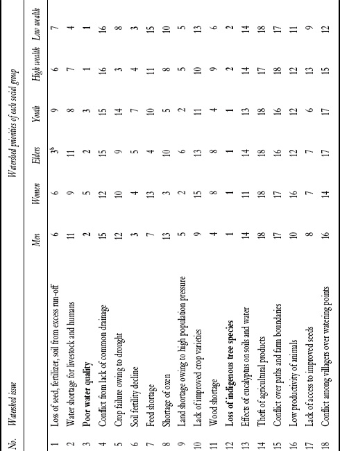
An example from the Ginchi site helps to illustrate how these principles are applied in practice. Thirty-nine watershed issues were identified by local residents in the Ginchi site and combined on the basis of their similarity into 18, namely:
1. Loss of water, soil, seeds, and fertilizers owing to excess run-off
2. Water shortage for livestock and human beings
3. Poor water quality
4. Problems associated with lack of common drainage
5. Crop failure from shortage of rains
6. Soil fertility decline and limited access to fertilizer
7. Feed shortage
8. Shortage of oxen
9. Land shortage owing to population pressure
10. Lack of improved crop varieties
11. Wood and fuel shortage
12. Loss of indigenous tree species
13. Effects of eucalyptus on soils, crops, and water
14. Theft of agricultural produce
15. Conflict over paths and farm boundaries
16. Low productivity of animals
17. Limited sharing of seed
18. Conflict between villages over watering points
These 18 issues were then ranked by different social groups in the watershed. The resulting ranks of the priority issues are presented in Table 3.10.
Several issues were considered either beyond the means of the R&D teams to address, or could only be addressed indirectly through other activities, for example addressing land shortages by intensifying crop and livestock systems or addressing drought through soil and water conservation. While the site teams decided to leave these issues out of subsequent clustering activities, this is something that should be reconsidered by others applying the methodology as opportunities for addressing more intractable problems might be lost by eliminating the issues from further discussion and analysis.
After applying the first principle—identification of watershed issues prioritized highly by most social groups, it was then necessary to apply the second principle; namely, identifying clusters of watershed issues with strong functional relationships. This involved looking at the short list of issues emanating from the participatory ranking exercise, and trying to lump them into smaller clusters based on their functional relationships—as defined by a biophysical (nutrients, water), social (conflict and cooperation), economic (competition among components or users for scarce resources), or other logic. When the Ginchi site did this, they ended up with the following clusters based on what they knew about the system:
TABLE 3.10 Rankings of watershed issues by social group, Ginchi benchmark site, Ethiopia

Notes:
a Watershed ranks were computed by taking the average of ranks given by each social group.
b Issues in italics are those the R&D team considered could only be addressed indirectly, through other activities.
Cluster 1:
• Poor water quality and quantity (for humans and livestock)
• Loss of seed, fertilizer, and soil from excess run-off
• Loss of indigenous tree species
• (Crop failure owing to drought)6
The rationale for this clustering is based on the recognition that: (i) water quality is being affected by seed, fertilizer, and soil run-off from fields; (ii) substitution of indigenous trees with eucalyptus has caused the depletion of groundwater and the drying of springs; (iii) integration of appropriate trees and soil conservation structures on the landscape could enhance spring recharge (water quantity) and reduce the loss of seed, fertilizer, and soil from the landscape; and (iv) crop failure owing to drought could be ameliorated by reducing water loss from run-off through water harvesting. The common logic behind the perceived relationships caused the team to name it the “Soil and Water Management” cluster.
Cluster 2:
• Soil fertility decline
• Wood and fuel shortage
• Loss of indigenous tree species
• Limited access to improved seed
• Feed shortage
• (Land shortage owing to population pressure)
This clustering of issues was based on the following observations: (i) loss of indigenous tree species and fuel wood availability has exacerbated soil fertility decline through the increased use of dung and crop residues for fuel (and the former must be dealt with to ameliorate soil fertility decline); (ii) intensification of the system to reduce land pressure will require a balancing act so that increased agricultural production (crop, livestock, trees) does not further compromise the already ailing nutrient status of the system; (iii) “improved” seed often requires high soil fertility, and places demand on already limited nutrient resources; and (iv) the traditional practice of rotating between cropland and fallow (for grazing) between seasons and years means that interventions in the livestock system will have a direct impact on the cropping system, and vice versa. The common logic behind these perceived relationships caused the team to name this the “Integrated Production and Nutrient Management Cluster.”7
These clusters are depicted graphically to illustrate the relationship between discrete problems and the integrated solution (Figures 3.4 and 3.5). The left-hand arrows in Figure 3.4 illustrate how solutions (middle of the diagram) do not address a single problem, but multiple problems simultaneously. In the same way, the three intermediate solutions can be further clustered into a single process of integrated (micro-) catchment management in which the whole is greater than the sum of its parts. For example, agroforestry practices should be able to add value to soil and water conservation objectives and water resource protection if the appropriate trees are selected for their functional role in addressing other watershed problems, as well as for the direct economic benefits they may bring. Alternatively, by addressing spring development as a high priority entry point, farmers may be more enthusiastic about trying out soil and water conservation measures or investing in the longerterm returns associated with the cultivation of tree species compatible with soil bunds, springs, and outfields.
In Figure 3.5, all issues identified in the cluster are represented with the exception of land shortage. As mentioned above, the R&D team decided that the land constraint would be addressed only indirectly, through the intensification of the crop, livestock, and tree components of the system. Our intention was not to suggest that such seemingly intractable issues should be marginalized up front; rather, we would encourage that such issues be fully explored to identify whether there are dimensions of the problem that can be taken on board by communities, the R&D team, or other actors. Limited availability of oxen was another issue identified by farmers but left out of the planning process by the team. One possibility put forward was to foster labor-saving technologies in other spheres to address the labor constraint implied by this concern, yet we found such linkage to be tenuous at best and instead constructed the diagram around the biophysical synergies we hoped to achieve. As farmers could very well have prioritized labor saving over productivity gains, this decision represents a value judgment and should be duly questioned together with farmers before proceeding into participatory planning and implementation.
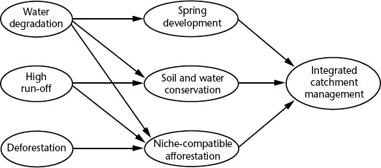
FIGURE 3.4 Soil and water management cluster
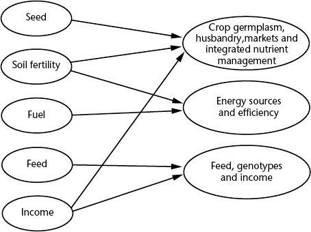
FIGURE 3.5 Integrated production and nutrient management cluster
Step 2—Integrated planning
Once clusters have been identified, integrated research and community action protocols must be developed to articulate both a vision and an operational plan for bringing change within each cluster. The overall objective of the cluster is first articulated, followed by the objectives of each integrated solution (the middle or right-hand circles in Figures 3.4 and 3.5, respectively). The objectives must express “higher-level” goals that go beyond any given discipline or system component to an integrated target that involves optimizing returns to different system goals (i.e., crop production, livestock production, nutrient conservation) or understanding trade-offs that emerge when giving greater emphasis to one system goal over others (i.e., production over water conservation). Through this approach, interventions within each sub-cluster are aimed at addressing problems within that area as well as within other sub-clusters with which functional linkages are strongest.
The following sample objectives from the Ginchi site help to illustrate what higher-level targets look like:
Objective 1 (Soil and water management cluster): To enhance the positive synergies between water, soil, and tree management in micro-catchments. Specific objectives corresponding to each sub-cluster are:
• To improve the quantity and quality of water for both human and livestock use and enhance community enthusiasm for future watershed activities.
• To reduce run-off (loss of soil, seed, fertilizer, water), improve productivity (of crops, trees, fodder), and enhance infiltration and groundwater recharge.
• To increase the prevalence of trees in their appropriate niches to minimize run-off while increasing the availability of tree resources (fodder, fuel, income, timber).
Objective 2 (Integrated production and nutrient management cluster): To improve farmer incomes and system productivity (including crops, livestock and trees) while ensuring sustainable nutrient management in the system.
Specific objectives corresponding to each sub-cluster are:
• To improve farmer incomes from crops through improved crop husbandry (including varieties and management), integrated nutrient management, and marketing (while ensuring sustainable nutrient management in the system).
• To improve the availability and quality of feed resources (while ensuring sustainable nutrient management in the system).
• To enhance the availability of fuel and tree income (while contributing to the restoration of system nutrients).
As originally stated (without the phrases in brackets), these specific objectives are phrased in such a way that the integrated approach to managing the resource base for multiple outcomes could be easily lost. For example, sub-teams managing each specific objective began to focus on conventional research topics—namely, component-specific goals (livestock productivity, crop productivity, etc.) rather than on their integration or optimization. When testing new barley varieties, for example, it is important to monitor not only grain yield—illustrating a bias toward the crop component, but also biomass yield for feed, and the resulting impact on soil nutrient stocks. When exploring alternatives for improving the productivity of fallows, it is important not only to consider the yield of feed, but also the yield of subsequent crops in the same area and the quality of dung which will be recycled in the cropping system. It is for this reason that it is important to manage the entire cluster as a whole rather than according to its sub-components. It is also critical to ensure that farmers—natural systems thinkers seeking to optimize diverse benefits from any given innovation—have strong decision-making and oversight powers to determine what options or innovations are to be tested and the key parameters to be observed or measured for each.
At this point, integrated research and development work plans are developed around specified R&D targets or objectives. To assist in developing action plans toward the achievement of these targets, it is important to define two types of activities and their respective contributions to learning and change:
1. Community-led learning and change processes; and
2. Research contributions (social, biophysical, economic, policy) that can assist watershed residents or support institutions to make well-informed decisions.
Detailed planning for each is required at both community and R&D team levels. Yet planning also evolves as the learning process evolves—with new community-led change and research priorities emerging as critical knowledge gaps hindering informed decision-making emerge. Planning at the level of R&D teams at this stage requires: (i) articulation of the facilitation process to be used to help communities meet their own objectives; and (ii) articulation of research questions and methods, and how research results will feed back into decision-making processes at community or higher levels. A protocol was developed for the purpose of helping R&D teams to structure the planning of integrated research and development interventions (Box 3.10). Table 3.11 illustrates the relationship between cluster-level objectives and research questions and specific sub-components of these protocols (community facilitation, action research, and empirical research). As mentioned in Chapter 1, action research is different from empirical research in both the questions asked and the methods used—with action research emphasizing the “how” questions (to answer the question, “what works where and why?”) and empirical research placing emphasis on the “what” questions (system characterization). Applications of empirical research in watershed management within AHI are summarized later in this chapter.
BOX 3.10 FORMAT FOR INTEGRATED R&D PROTOCOLS FOR EACH CLUSTER
1. Title
2. Background and justification
• Problems in the cluster and why they are functionally linked
• Why the problem persists despite community concern and the rationale for new types of interventions (including facilitation and research)
3. Cluster objective and primary research question (see Table 3.11)
4. Community facilitation process
• How the overall change process will be facilitated for reaching the cluster objective (key steps, who to be involved and why, facilitators and facilitation process)
• How action research and empirical research are sequenced in time with the facilitation process (i.e., how new knowledge will be used to inform decision-making)
5. Action research
• Research question 1 (research methodology; research outputs and how they will be used)
• Research question 2 (research methodology; research outputs and how they will be used)
6. Empirical research
• Research question 1 (research methodology; research outputs and how they will be used)
• Research question 2 (research methodology; research outputs and how they will be used)
7. Roles and responsibilities
• Who will be responsible for leading each cluster, and for each research question and output?
Lessons learned
The following lessons were learned in efforts to apply and improve upon the methodology for research and development team planning for landscape integration:
• Planning for integrated research and development interventions at R&D team level was instrumental in reaching a common understanding of the complexity of management challenges facing farmers, and of how to organize the team to assist in navigating amidst this complexity.
• Planning at R&D team level must be iteratively validated and informed by watershed residents themselves, both as inputs to the planning process and as a means to raise awareness among farmers of the functional relationships being targeted by integrated interventions.
• Integrated planning is challenging, but staying integrated in practice is much more challenging. Researchers and practitioners trained within single disciplines or sectors will tend to sway toward conventional views and biases, forgetting to look at the system as a whole. For research, planning at the level of variables to be measured (for empirical research) or indicators to be monitored (for action research) helps to ensure multiple perspectives are considered. For further details on this methodology, see German (2006). For community facilitation, having cluster leaders within R&D teams to keep individual members focused on the bigger cluster goal and their activities aligned with this goal, and fostering integrated planning and monitoring at community level, are both instrumental.
TABLE 3.11 Planning framework for integrating diverse learning approaches in research and development
| Major activity/step | Objective step | Facilitating participatory action learning and action research | Action research questions | Empirical research questions |
Watershed diagnosis |
To identify major watershed problems from the perspective of local residents. |
Primary Research Question: What are effective, equitable processes for participatory diagnosis and planning for watershed management? |
||
|
|
1. Consultations with diverse social groups to identify key watershed problems, and opportunities and barriers to their resolution. 2. Development of participatory watershed action plans. 3. Program-level planning for integrated R&D interventions |
1. What is an effective approach for planning at local and program levels? 2. How can problem diagnosis be balanced with the need for immediate impact, so as to keep community interest high? |
1. What are watershed priorities by gender, age, wealth, and landscape position? 2. What are key opportunities and barriers to addressing identified watershed problems? 3. How effective are current by-laws and natural resource governance? |
Soil and water conservation (SWC) and management |
To enhance the positive synergies between water, soil, and tree management in micro-catchments. |
Primary Research Question: How can natural resource management innovations enhance agricultural productivity through decreased run-off (reduced loss of soil, seed, fertilizer, water) while enhancing spring recharge in the long term? |
||
|
|
1. Spring development with spring management plans (responsibilities, rules, sanctions). 2. Negotiation support and local by-law reforms for spring maintenance, common drainage ways, investments in spring recharge, and greater niche compatibility in agroforestry. 3. Adaptive research on SWC structures and niche-compatible afforestation to control erosion, enhance water recharge and minimize loss of inputs. |
1. If a high-priority entry point (spring development) is used, will outcomes of future R&D investments be greater? 2. What are the necessary conditions for people to invest in a shared resource? 3. What are effective approaches for reaching the overall cluster objective? |
1. What is the impact of chosen SWC measures on run-off, soil and nutrient loss, and infiltration? 2. What are farmers’ key indicators for SWC, and how do these change over time? 3. Which trees are compatible with different niches? How do prioritized tree species perform in different niches? 4. Who are the stakeholders for each issue, and how do they view the cause and solution? |
Integrated production and nutrient management |
To improve farmer incomes and system productivity (crops, livestock, trees) while enabling sustainable nutrient management. |
Primary Research Question: How can income be improved through increased agricultural productivity (of crops, livestock, and trees) and marketing while maintaining or enhancing system nutrient stocks? |
||
|
|
1. Test alternative crop, feed and livestock husbandry practices and monitor effects on the system. 2. Raise awareness on fuel-nutrient dynamics; negotiate and test viable alternatives (fuel-efficient stoves, afforestation, regulations on dung collection from outfields). 3. Negotiation support for benefits sharing and collective investments in outfields (nutrient management, alternative fuel source). |
1. What is an effective and sustainable approach for scaling out tested varieties and integrated nutrient management technologies? 2. What are effective approaches for improving livestock and feed production, minimizing system nutrient loss, and catalyzing collective investments in a sustainable fuel supply? |
1. What is the effect of different varietal-nutrient management combinations on yield, income, plot fertility and system nutrient dynamics? 2. What is the effect of different feed and management innovations on income, livestock productivity, and system nutrient dynamics? 3. How much energy/fuel wood is needed to substitute unsustainable fuel sources? What is the “absorption capacity” of trees in different types of households and landscape niches? |
Selecting entry points
The basic characteristics of good entry points were highlighted in Chapter 2. In AHI, two different types of entry points were used to bring early benefits within new watershed villages. A description of each approach and its underlying principles is provided below.
Approach development
Approach 1—Use of farm-level entry points
The first set of entry points builds upon prior work in the participatory farmlevel innovation theme, because at the farm level is where new technologies are validated on farmers’ fields before more widespread dissemination. The properties of these entry points should be in accordance with known principles specified in Chapter 2, namely: is of high priority (addresses felt needs of intended beneficiaries); able to bring quick benefits (often economic in nature); and has been previously tested (thus carrying low risk). A few case studies help to illustrate how farm-level entry points have been applied at early stages of watershed management within AHI benchmark sites (Box 3.11).
BOX 3.11 FARM-LEVEL ENTRY POINTS
Taro in Areka—Farmers in Gununo watershed quickly gained confidence in AHI interventions during watershed entry owing to the multiple benefits derived from the dissemination of a new taro variety called Boloso-I. The variety gives higher yield, requires less time and wood fuel to cook, has a good texture and lower concentration of oxalic acid, and generates more income compared to local varieties. This early success increased rates of repayment of in-kind loans (in the form of planting material) and increased community participation in subsequent meetings following the intervention. Therefore, technologies that bring quick benefits in the form of increased food security and income can serve as excellent entry points and improve the likelihood of community investment in future activities.
Tomato in Lushoto—During the PRA in Phase 2, farmers complained of low income from their enterprises. While exploring options for improving income, they mentioned the need for tomatoes that can withstand long-distance transport to distant markets in Dar es Salaam and Arusha without being damaged. New varieties were tested, and two were found to be much better performing in this regard, and therefore in great demand by intermediaries. The great success of this crop in bringing income quickly (within 4 months) at low risk (most households have access to valley bottom land and some irrigation water) made it a very successful entry point when expanding activities beyond Phase II villages to the watershed.
Approach 2—Use of watershed-level entry points
Landscape-level entry points have similar properties to farm-level entry points, but bring benefits at community rather than household level. Two cases from AHI help to illustrate this, and the importance of jointly considering diverse criteria (high priority, quick benefits) when selecting entry points (Box 3.12). In Ginchi, for example, spring development was chosen over the highest priority watershed issue (loss of indigenous tree species) owing to its ability to bring quick returns to the community.
BOX 3.12 LANDSCAPE-LEVEL ENTRY POINTS
Spring development in Ginchi—In Ginchi, the participatory ranking process identified in the participatory watershed planning session highlighted loss of indigenous tree species as the highest priority across most social groups (Table 3.12). However, as this entry point would defy a key principle of entry points (that it yields quick returns), the second priority across many social groups was selected. The community was mobilized to contribute labor, material (rocks, sand) and small sums of money for constructing cement structures around springs to protect water quality. Farmers were highly enthusiastic, with one individual exclaiming, “I had no idea the kind of water you buy in bottles can come from this spring.”
TABLE 3.12 Final ranks of the top two watershed issues in Ginchi site
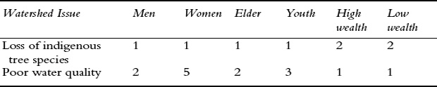
This entry point was also selected to create an incentive for community investment in ensuring long-term water supplies (a benefit with more delayed returns) through soil conservation structures designed to enhance infiltration and spring recharges as well as increase land productivity.
Controlling run-off in Kabale and Kapchorwa—For a long time, people in highland areas of eastern Africa have struggled with the challenge of effectively controlling excess run-off and landslides that destroy crops, fields, property, infrastructure and even lives. In the process of trying to overcome these challenges, different innovations have been tried with limited success. One of the most effective strategies in Kabale was the use of check dams together with local by-laws (an innovation of Africare). Cross-site visits to Igomanda Watershed by farmers from Rubaya and other sub-counties exposed farmers to these successful innovations and aroused their keen interest in working collectively toward adopting these best practices. The entry point, in this case, included several complementary elements: a cross-site visit, the technology, the by-laws and a few tools required for heavy digging. This led to overwhelming levels of community enthusiasm and collective action, as evidenced by 100 percent household participation.
In Kapchorwa, recent landslides led villages in the Tuikat Watershed to highlight this as their top priority. Cross-site visits were also used to learn from other farmers in Kaseko Parish who had been supported earlier on by the Kapchorwa District Landcare Chapter, mobilizing the community's commitment to apply these innovations to landscape areas most affected by landslides and excess run-off. Within two weeks, 50 percent of households in the watershed had adopted the innovation, banning free grazing to further control land degradation and ensure survival of tree seedlings planted on the contours.
Lessons learned
The following lessons were learned through our experience in testing diverse types of entry points for watershed management:
• The same principles apply for watershed entry points as for farm-level entry points (high priority, quick returns, previously tested), yet previous testing does not have to be from the same institution or project—as illustrated by the use of spring development as an entry point for stimulating innovations in agriculture and NRM.
• The scale of intervention (farm vs. landscape) does not have to be a determining factor in selecting entry points; proven farm-level entry points can mobilize community enthusiasm for future landscape-level innovations. Some watershed-level entry points may have an added biophysical advantage over and above the social advantage conferred by ensuring quick benefits to communities. For example, it was hypothesized that spring development—an entry point that brings immediate improvements to water quality—might catalyze community interest in building soil and water conservation structures above the springs to help ensure a long-term water supply through groundwater replenishment.
• The success of entry points does not depend only on immediate livelihood improvements. Entry points can also be evaluated on the basis of the social capital built among community members and the effect this has on their confidence to engage in other collective endeavors in the future.
Empirical research inputs into decision-making
Action research is not a substitute for empirical research. The latter can be instrumental to decision-making for individual farmers as well as R&D teams and policy makers.
Approach development
Approach 1—Scientific data as inputs to decision-making
Scientific data can be instrumental in bolstering political commitment to a new approach (for example, impact assessments to illustrate the relative merits and demerits of new approaches for agricultural research and extension) or to new policies. The latter may be shown in research conducted in Lushoto to help legislators make tough decisions about whether and how to regulate eucalyptus cultivation in the district (Box 3.13). Scientific research can also make new indicators visible to farmers, raising awareness and mobilizing their interest in finding solutions. This is best illustrated by a case study from Ginchi, where soil erosion experiments helped to make visible the benefits of soil erosion control (Box 3.14). It has also been shown to empower communities to question the actions of more powerful actors, as illustrated by a case in Lushoto where scientific experiments were used to bolster support from external agencies in enforcing new boundary management practices less detrimental to farmers’ livelihoods (Box 3.13). Finally, scientific data from watershed exploration and diagnostic work can help to ground interventions by identifying problems important to local residents, environmental hot spots (where these problems are most extreme), social conflicts, opportunities (i.e., local institutions respected by most parties) or other important guiding parameters.
BOX 3.13 SCIENTIFIC RESEARCH CAN HELP INFORM POLICY MAKERS AND LEGITIMIZE LOCAL STAKES VIS-À-VIS MORE POWERFUL ACTORS
During the participatory watershed diagnosis, farmers mentioned the incompatibility of eucalyptus with adjacent farmland as a multi-stakeholder problem among neighboring landowners. Since this problem can be partially addressed through policies regulating the location and density of eucalyptus on or near farm boundaries, empirical research was undertaken to assess soil chemistry, soil moisture, and maize yields near boundaries of eucalyptus and other species perceived by farmers to be harmful to crops. Identification of significant negative impacts on crop yields or thresholds (specific distance from tree lines at which negative effects rapidly decline), as illustrated in Figure 3.6(b), would both be useful for guiding policy. While the former would provide a justification for a policy intervention in the form of restrictions on species or planting locations, the latter would provide a clear design principle for such interventions (i.e., species X not to be planted within Y meters of farm boundaries).
FIGURE 3.6 Hypothetical impact of boundary trees on the yield of adjacent crops in cases with (b) and without (a) thresholds
While this was the motive for conducting this research, one farmer living next to the Sakharani Mission and “hosting” an empirical research experiment used the clear visual evidence of reduced yields near the Sakharani boundary to support his interests. He requested the District Forest Officer to visit his field, see the outcomes of the experiment, and demand for land-use change by the Mission in the form of substitute species compatible with adjacent cropland. Clearly, such experiments can have both intended and unintended outcomes for livelihoods, learning, and social justice.
BOX 3.14 SCIENTIFIC RESEARCH CAN MAKE VISIBLE PROCESSES OTHERWISE DIFFICULT FOR FARMERS TO SEE
While gulley and rill erosion are highly visible to farmers, sheet erosion is less visible. Furthermore, farmers tend to focus on immediate economic needs over long-term sustainability, making them focus more on the damage caused by excess run-off over soil loss per se. Field demonstrations linked to scientific research proved to be instrumental in Ginchi for raising awareness by making new processes that are otherwise difficult to observe visible to farmers. An experiment in the Ginchi site was conducted using run-off plots and three treatments: (i) plots without conservation measures planted with barley; (ii) plots with soil bunds planted with barley; and (iii) fallowed plots. Water and sediment were collected at the bottom of each plot, with water color and the amount of sediment now visible indicators of soil loss in each of the three treatments (see Plate 9). Since the experiment was located near the main road, several farmers inside and outside the watershed were observing these indicators and became convinced of the importance of soil bunds in reducing both run-off and soil loss. During a farmers’ field day conducted in October 2006, one farmer stated that, “seeing is believing.”
Approach 2—Local knowledge as an input to decision-making
Systematic studies of local knowledge using social scientific methods can also help to make highly specialized or localized knowledge available to a broader community, creating opportunities for collective solutions to a shared problem. The “formalization” of local knowledge can be useful for a number of reasons. The first is the specialized nature of local knowledge, in which some members of a community may know much more about a topic than others owing to natural variations in individuals’ interests and experience or incentives that keep that knowledge from being shared (Box 3.15). Formally documenting local knowledge can also help in multi-stakeholder negotiations, either by identifying inconsistencies in the knowledge systems of different stakeholders (and the need to reconcile these differences), or by feeding common local understandings on cause and effect into decision-making processes (Box 3.16). Finally, studies of local knowledge can help to target intervention strategies that are most strategic and to identify traditional practices already proven in addressing local social or environmental concerns (Box 3.17).
BOX 3.15 LOCAL KNOWLEDGE ON VERTEBRATE PESTS: SPECIALIZED KNOWLEDGE AND BARRIERS TO SPONTANEOUS SHARING
Research into local knowledge of porcupine and mole rat control in Areka was instrumental in finding a way to address the damage they cause to crops. The content of local knowledge included both control methods and the landscape locations where these are effective (Table 3.13). Yet this knowledge had not been effectively mobilized by the community to control the pests because they lacked institutions of collective action for doing this, and some of the more effective local control practices were not understood by the majority of community members. Some of the knowledge proved to be highly specialized and coveted, as the few farmers familiar with them earned income from controlling porcupines and mole rats on others’ fields and benefited through secrecy. Making this knowledge more available to the broader community and using it to mobilize all residents to assist in control efforts were fundamental to addressing the problem.
TABLE 3.13 Characteristics of local control methods for porcupine
Control method |
Niches where applied |
No. of knowledgeable farmers |
Wire body traps |
Grassland; graveyards; forest; under eucalypts and bamboo |
One |
Deep digging at outlet of porcupine hole |
Grassland; river beds and banks; under eucalypts and bamboo |
Many |
Circular ditch |
Graveyards |
Many |
BOX 3.16 SOCIAL SCIENCE RESEARCH ON LOCAL KNOWLEDGE AS INPUTS TO MULTI-STAKEHOLDER NEGOTIATIONS
In Ginchi and Lushoto, local knowledge on the properties of different tree species and their suitability to different landscape niches was used as a first step in addressing problems related to incompatible trees on farm boundaries (competing with cropland), near springs (drying up springs and changing the taste of water), and on state land (where trees planted along roads and boundaries of protected areas compete with crops and cause the drying of springs). This knowledge was used for: (i) identification of niches where trees are or could be grown; (ii) identification of culturally important, harmful, and niche compatible (and incompatible) trees; and (iii) identification of the properties that make species compatible and incompatible with different niches. Participatory ranking was done to assess the degree to which different species exhibit different properties or “niche compatibility criteria” (German et al., 2006b). These data were then fed back to stakeholders during negotiation support processes to identify tree species exhibiting properties important to each stakeholder group, and species to be avoided in particular landscape niches (German et al., 2006a).
BOX 3.17 LOCAL KNOWLEDGE ON SPRINGS: IDENTIFICATION OF ENVIRONMENTAL “HOTSPOTS” AND TESTED SOLUTIONS
In Lushoto, social research on local knowledge of the causes and consequences of spring degradation helped to target appropriate solutions to this priority problem. First, identification of historical trends in spring degradation helped to identify springs for priority intervention based on: (i) the perceived threat to the resource (status of vegetation, historical changes in spring discharge); and (ii) the “social importance” of the spring (its importance as a function of distance to households, volume and seasonality of water, and number of users). Studies of local knowledge also helped to identify tree and grass species with conservation functions that researchers were unaware of, which were subsequently utilized to rehabilitate degraded springs. Finally, such research can help to validate traditional knowledge on environmental conservation that is coming under threat from changing belief systems. A traditional taboo forbidding the collection of crabs in springs, for example, may very well have an important conservation function as many crab species are known to manipulate water quality by removing detritus and circulating and oxygenating the water (Schubert et al., 1998).
Lessons learned
The following lessons have been learned in AHI attempts to integrate scientific research into development and natural resource management processes:
• Scientific knowledge is most useful when employed to make the (otherwise hard-to-see) consequences of local natural resource management practices visible to local actors and used to inform ongoing change processes.
• Value added from integration of scientific research into participatory watershed management may derive from a number of different things: its role in awareness creation (making visible previously invisible processes and unthinkable opportunities); its ability to help shed new light on cause-and-effect relations that need to be understood in the context of negotiated decision-making or policy design; supporting community advocacy vis-à-vis government agencies and more powerful actors; and for mobilizing the potential of local knowledge in local problem-solving.
• Local knowledge may be more effectively applied if combined with other forms of external support, including social science research to legitimate, systematize, or publicize it.
• Symbolic explanations for biophysical processes, often disrespectfully called “superstitions,” should not be discredited because they are not explained through scientific rationales. Not only do these explanatory frameworks often explain underlying biophysical processes in ways consistent with scientific explanations, but discrediting them may have negative effects on sustainability by eroding the natural resource management practices they help to sustain and encode.
Participatory monitoring and evaluation
Monitoring and evaluation is perhaps the most fundamental step to participatory integrated watershed management because without active monitoring at community and project levels, other investments of time and energy are likely to yield few returns. Monitoring helps to capture challenges early on so that they may be addressed before they lead to failure. It also enables opportunities to be effectively captured by identifying them and fostering agreement on how they can best be seized. By monitoring, participants can share their views on the challenges faced, generate “best bet” solutions, and agree on how these solutions will be put into practice through revised work plans and division of responsibilities.
Approach development
AHI has experimented with approaches to participatory M&E at both community and R&D team levels. This section profiles three distinctive approaches. The first two approaches emphasize participatory M&E at community level, the first drawing on local concerns or indicators alone, and the second employing exogenous indicators and/or scientific methods. The last approach illustrates participatory M&E at the level of research and development teams.
Approach 1—Participatory monitoring and evaluation (PM&E) with communities
Within AHI, approaches to participatory monitoring at community level, based on observations of local residents themselves, have included both informal and formal approaches. Case studies help to illustrate how feedback elicited from farmers during implementation helped to change the approach being used for improved impact, as lessons were learned through implementation.
(i) Informal PM&E at community level
The first strategy has been simply to ensure a continuous presence in the watershed, and to continuously ask watershed residents (both active and less active ones) how they view or perceive the effectiveness of ongoing activities. This can occur through active questioning or through sharing time together informally over a cup of tea or through other forms of socializing. It is often through such informal interactions that the most honest reflections are shared.
Case 1—Monitoring the “mood” of the community during watershed exploration to sustain community enthusiasm
Although watershed delineation and characterization were seen as a necessary step by the Lushoto team—providing baseline information and helping to identify constraints to livelihoods and improved natural resources management, these processes took time. Participatory diagnosis and prioritization of watershed issues and participatory watershed planning, while more engaging, also took time. Once planning was finalized, diverse sub-teams engaged farmers in more detailed planning meetings and training workshops on select themes. All of these activities placed demands on farmers’ limited time, and diverted them from other important activities. While farmers were getting fatigued, frequent visits by the R&D team, together with open communication and good rapport between team members and farmers, enabled farmers’ concerns to be expressed openly. Researchers were therefore in a position to respond and to brainstorm on ways to keep farmer enthusiasm high. Issues of highest concern by farmers, identified during early phases of characterization and diagnosis, became the subject of discussions on how to bring immediate impact and sustain farmers’ trust and enthusiasm. It was planned that some efforts and resources should be invested in the rehabilitation of degraded water sources. Local residents were asked to identify water sources to be rehabilitated using jointly agreed upon criteria, including level of degradation and number of households depending on the water source. Several water sources were chosen and communally rehabilitated through contributions from local residents (stones, sand, labor) and the project (technical, cement, and financial). Water source sanitation and water levels were observed to immediately improve, restoring confidence of the community in the program as a whole.
(ii) Formal PM&E using local indicators
The most notable difference between informal and formal PM&E is the latter's explicit use of local indicators to monitor performance. Rather than following a complex typology of principles, criteria and indicators, here ‘indicators’ were loosely interpreted to include quantitative or qualitative statements that can be used unambiguously to describe desired situations and measure changes or trends over a period of time. Use of locally formulated indicators helps to foster a shared understanding of the objectives being sought, and what a successful change process should look like. It is important to note that the indicators of “success” for one individual or group may not be the same as for others. It is therefore necessary to either: (i) seek broad consensus on the indicators chosen, and to ensure that diverse views are captured; or (ii) carry out stakeholder-based M&E to ensure that the interests and concerns of diverse interest groups are adequately captured and monitored among groups sharing common interests.
Steps to formal PM&E using local indicators are summarized in Box 3.18. For stakeholder-based monitoring, stakeholder analysis would come as a first step, and different stakeholder groups would be encouraged to formulate their own views when monitoring the performance of local indicators (in Steps 4 and 5).
BOX 3.18 BASIC STEPS IN PARTICIPATORY M&E
1. Identify objectives of the activity to be carried out. This can be defined at the cluster level, or at the level of specific problems being addressed.
2. Identify local indicators. This can be done by asking the following questions: “If [activity X] is successful, what will be different in [6, 12, 24 months’] time? What changes will you see?”
3. Set a schedule for follow-up meetings to monitor progress.
4. Monitor progress according to established indicators. This can be done by asking the following questions: “You mentioned that if you are successful, you will see [e.g., more water discharge from springs]. Have you observed any changes yet in [spring discharge]?”
5. Revised work plans as needed to adjust activities so that the ultimate objectives are more likely to be achieved. This can be done indicator by indicator, for example by asking the question, “Is the observed change in [indicator X] enough, or does more need to be done to see [e.g., more water discharge from springs]?”
The following case studies help to illustrate what the use of local indicators and stakeholder-based monitoring looks like in practice. The first case study also demonstrates how monitoring of local indicators may be used to monitor successive stages of a single approach or different approaches tested over time.
Case 2—By-law reforms in Kabale
Two waves of participatory by-law reforms were carried out in Rubaya Sub-County over the course of several years. Formal participatory monitoring was done using a combination of indicators proposed by local communities and project facilitators to observe how these two approaches, implemented sequentially, compared to one another and relative to the pre-intervention period. Table 3.14 illustrates the nature of outputs from this type of monitoring.
These findings clearly show the incremental nature of local governance improvements, where villages with prior experience implementing NRM by-laws were more effective in utilizing by-law reform processes to catalyze collective action.
Case 3—Equitable technology dissemination in Areka
A case from Areka also helps to illustrate how participatory monitoring using local indicators may be done. Following the approach to equitable technology dissemination described in Chapter 2, mixed groups of farmers from each village were called together to assess how different local indicators were performing. Groups were asked to do matrix ranking to compare the approach used by the formal extension service with the AHI approach. Participants were asked to discuss the relative performance of the two approaches for each indicator, and to use seeds to rank the two approaches based on their perceived performance (with more seeds meaning better performance). Results are presented by approach, with “before” representing formal government extension and “after” the AHI innovation, in Figure 3.7. While this approach to evaluation does not explicitly capture views of different stakeholders (e.g., by gender and wealth), participants were asked to jointly reflect on the effects of different approaches on women and poorer households. While this evaluation method has the benefit of generating a collective awareness of the performance of different extension approaches for different stakeholders, it may not be effective in ensuring the voice of those same groups are adequately captured. Subdividing the group of farmers by gender or assets (e.g., landholdings) for matrix ranking and then comparing the outcomes would ensure diverse perspectives are captured. The presentation of these gender- or wealth-disaggregated results would involve the generation of two figures (one for each group), or the inclusion of additional columns (to represent how different groups evaluated each approach).
TABLE 3.14 Performance of identified indicators by phase of intervention

FIGURE 3.7 Farmers’ perceptions of the relative equitability and benefits of the AHI/HARC approach as an alternative to that employed by the Government Extension Service, Areka, Ethiopia
Note: The AHI/HARC approach (“After”) included negotiation support to agree on mechanisms and rules for equitable access; participatory by-law reforms to support local agreements; and in-kind credit.
Approach 2—Formal M&E using scientific indicators or methods
Formal M&E can draw on scientific principles or methods of data collection in a number of ways. One way is for local communities to identify indicators and for scientific methods to be used to gather data and monitor performance of the indicator. This approach consists of the following basic steps:
1. Identify objectives of an innovation process together with farmers representing different social or interest groups.
2. With each group, identify local indicators that will be used to monitor progress toward agreed objectives. This may be done by asking participants, “If you are successful in [achieving objective X], what changes will you see? What will be different in [2 months’ time, 6 months’ time, 2 years’] time?”
3. Researchers may also suggest indicators they think are important for monitoring, and explain the reasons why (e.g., they are complementary to farmers’ indicators, help to capture outcomes of importance to the project—such as equity or sustainability, etc.).
4. Researchers and farmers agree which indicators will be monitored by whom, and how.
5. Researchers and farmers jointly develop an action plan to articulate the activities to be undertaken, who is responsible for each, the timeframe and plans for feedback of findings to the wider group (including for researchers to share any findings from the scientific or local indicators they are charged with monitoring).
This approach is again illustrated by the porcupine case from Areka, where scientific methods were used for unbiased sampling and systematic data collection in the monitoring of local indicators through formal household surveys, and the results shared back with farmers to enable them to take appropriate actions. Farmers were asked to identify local indicators for assessing performance of the activity. These included levels of crop loss for crops that are economically important and susceptible to attack, time spent and number of family members involved in guarding fields at night, and incidence of weather-related illness resulting from high levels of exposure to the elements when keeping watch of fields by night. These were measured by research across a representative number of households, and results compiled (Figure 3.8).
The most marked livelihood benefits were found to result from reduced crop damage, improved health, and labor savings. Levels of crop damage were reduced by 80 percent following intervention, while frequency of visits to health clinics as a result of weather-related illness also declined. Yet one of the most important successes in the minds of farmers was the reduction in efforts required to guard fields at night. Such an indicator could have been easily overlooked had scientists been the only ones to identify indicators to be monitored, yet it was the most critical success in the minds of farmers.

FIGURE 3.8 Observed impacts from collective action in porcupine control
Another example of formal monitoring, using a combination of local and scientific indicators to track spontaneous farmer-to-farmer spread of technologies, was presented in Chapter 2.
Approach 3—Participatory M&E at R&D team level
“Participatory” M&E or self-reflection at the level of R&D teams is also necessary for a number of reasons. First, it helps to align activities with specified objectives, community facilitation processes, and research protocols. Implementation is always easier in theory (during planning) than in practice; therefore, self-reflection among R&D teams is an important component to backstopping community-led efforts. It also helps to monitor contributions from different organizations and team members, to ensure that all team members are fulfilling their roles and responsibilities. Finally, and perhaps most important for AHI, it has served as a platform for team learning and innovation by fostering group reflection, cross-checking of assumptions, and fine-tuning how different disciplinary perspectives are articulated within community facilitation and research practice.
In AHI, “participatory” or self-monitoring was conducted largely through periodic meetings among R&D teams. These meetings consisted of reflections on progress made since the last meeting, discussions on how to improve team performance and innovate in line with program objectives and community priorities, and to adjust work plans accordingly. The content of reflections included both the technical content of watershed work (for example, to collectively assess the extent to which behaviors reflect principles of participation and integration) and the approach to teamwork itself. The latter might include, for example, joint reflection on the extent to which the team is simply planning together as opposed to learning together in the field. For reflections on how the team as a whole is interfacing with watershed communities to foster change, a process documentation methodology was used to facilitate systematic reflection on the same. This methodology is illustrated in Box 3.19.
BOX 3.19 FORMAT FOR PROCESS DOCUMENTATION
I. Prior to any activity or step (planning stage):
Objective: What are you trying to achieve in the particular community intervention being planned for?
Approach: What is it that you will do to achieve the objective? (What steps will be taken? Why did you choose these steps? Who will you involve, and why?)
II. Following any activity or step (reflection stage):
Approach: What did you actually do to achieve the objective? [The planning process for such community events is rarely complete, as there are always unforeseeable circumstances that affect the facilitation process. How was the approach modified during the event itself to accommodate these changes, and why?]
Successes and challenges: What went well? What did not go well? [This should include reflections of the successes and stumbling blocks faced by the communities or stakeholders since the last meeting, as well those faced in the facilitation process itself. It should also include observation of why these successes and challenges occurred, providing lessons for others wishing to learn from your experience.]
Findings: What did you learn that you did not know before? [These findings are generally derived from statements about reality made by farmers or other participants, which were new to the facilitators.]
Resolutions: What decisions were taken by participants? [These should include agreements reached by the participants about the principles behind the work, and about the way forward.]
Lessons: What lessons or insights can be derived from these experiences to share with others trying to carry out similar activities? [These should include things you were surprised to find out, both about the approach that was used to engage with communities and about the findings.]
Recommendations: Replanning. [Here the team should reflect on what they would do the same and differently next time to build upon successes and overcome challenges faced during implementation. This can be for the benefit of the team itself in terms of approving outcomes from similar activities to be conducted in other locales, or for purposes of sharing experiences with a wider audience.]
The following case studies help to illustrate the importance of frequent monitoring at the R&D team level. The first illustrates use of R&D team monitoring to learn lessons in the field, and the second the importance of continuous monitoring of team performance to achieve greater integration of disciplines, perspectives, and system components.
Case 1—Use of process documentation tool to reflect on methods for multistakeholder negotiation
The process documentation tool presented in Box 3.19 has proven to be an important tool for fostering learning at the level of R&D teams on approaches under development. It has been used as a means to operationalize action research—namely, to learn lessons “what works, where, and why.” Such a tool can assist in advancing iterative, cumulative learning over time on any given case, or to learn lessons across cases on a particular set of approaches, such as the facilitation of multi-stakeholder negotiation processes. For the latter, cross-case comparison could contrast a set of facilitation approaches when applied in different landscape niches (springs, farm boundaries, and waterways), different topics (niche-compatible agroforestry, free grazing, soil and water conservation) or different contexts (districts, countries, agro-ecological zones). Ultimately, it assists R&D teams to reflect on learning and to decipher emerging patterns. These patterns might be seen through iteration—a sequential approach to learning in which different approaches are tested over time, evaluated and modified as needed to address weaknesses. In this approach, outcomes obtained at different stages of the innovation process are observed to distil key points in time—and elements of the approach being applied at that point in time—that brought the most profound change. They may also be deciphered through comparison—namely, trying a similar approach across different cases and observing how theme, stakeholder characteristics, or context influence the outcomes in each case.
An example of a process documentation output helps to illustrate how the methodology is used in practice (Box 3.20). This case documents a single meeting in which two stakeholders—the Sakharani Mission and neighboring farmers—were brought together to negotiate more socially optimal land-use practices to address latent conflict. The event followed preliminary activities to diagnose watershed problems from farmers’ perspectives, ethnoscientific research to document local knowledge on the properties of different tree species and their positive and negative effects within different niches, and preliminary stakeholder consultations.
BOX 3.20 PROCESS DOCUMENTATION OF MULTISTAKEHOLDER NEGOTIATIONS FOR THE SAKHARANI BOUNDARY CASE
I. Prior to activity/step
Objective: To advance multi-stakeholder dialogue and planning for improved management of the Sakarani boundary.
Approach (as planned):
1. Call together stakeholders (Sakharani farm manager, affected farmers, and local leaders from neighboring villages) for multi-stakeholder negotiations.
2. Share steps carried out so far (and findings): (i) Participatory watershed diagnosis (competition of eucalyptus planted on farm boundaries with crops and water); (ii) Research on local knowledge (niches needing improved management, species causing problems, niche compatibility criteria of farmers); (iii) Stakeholder consultations with Sakharani and neighboring villages.
3. Solicit reactions and clarification from participants.
4. Negotiate “binding” criteria for tree species selection by prioritizing the most important in the list of niche compatibility criteria mentioned by each stakeholder (farmers: improves soil fertility, produces few seeds, crop-compatible, small shade, does not dry soil; Sakharani: secures boundary, fast growing, coppices, few branches, good for fuel, lumber, and income).
5. Identify tree species that fit combined criteria.
6. Develop work plan with activities (what?), responsibilities (who?) and timeline (when?).
II. Following activity/step
Approach (as actually carried out):
• Rather than negotiate “binding” criteria, we went directly to the negotiation of tree species acceptable to both parties, as it was conceptually easier for both parties.
• We did not plan the “when” in work plans, owing to time limitations and the need to consult more people before making specific work plans.
• [S]: The event successfully overcame the communication impasse and led to agreements to address the latent conflict.
• [S]: The outcome was favorable to both parties, as it addressed concerns of both.
• [C]: Representation of different hamlets was not good; the meeting dragged on for long.
Findings:
• Sakarani rejected peach as a boundary tree (because fruits would attract villagers), resulting in the addition of a new “binding” criterion to the list.
• Mtalawanda (Markhamia obustifolia) has drawbacks for both stakeholders (slow growing, produces many seeds), but advantages outweighed disadvantages (height, limited branching, and shade, compatibility, life span).
• Agrocarpus is not a good boundary tree because its roots invade farmland and compete with crops.
Resolutions:
• To replace eucalyptus with Mtalawanda.
• To hold a second meeting with all farmers bordering Sakharani to discuss a detailed plan for the felling of eucalyptus and managing tree seedlings, to be called by the Village Executive Officer.
• A host of technical and policy solutions for rehabilitation of springs and waterways (buffer zones, water-conserving vegetation, by-law reforms and enforcement).
Lessons/Insights:
• Terminology matters, either polarizing the issues (e.g., “stakeholder”) or minimizing conflict (“party”).
• Use of language to manage power dynamics is essential, for example acknowledging the property rights of the landowner by asking him whether he can accommodate the concerns of the other party.
• Crucial role of a third party to bring dialogue in situations of latent conflict, and the power of simple dialogue in unlocking deadlock.
• It is easier to discuss niche-compatible species than niche compatibility criteria.
• Move directly from sharing the niche compatibility criteria of each stakeholder to negotiating species acceptable to both parties. Return to specific criteria only if solutions are not forthcoming.
• Divide approach into several steps: a) preliminary dialogue with tentative solutions, b) broader consultations (follow-up meetings with affected farmers), and c) development of final work plans.
By observing and documenting these experiences through iteration (sequential phases of innovation and learning on the same case), we learned a number of important lessons. The first is that it is essential to involve the right authorities in decision-making. Failure to involve Fathers higher up in the Benedictine order caused difficulties for the farm manager when it came to implementing agreements. A second lesson is the need for detailed planning, for example going beyond criteria to guide the sequence of tree felling (i.e., where trees posed a risk to households, followed by areas where trees posed a risk to cropland) to specific locations. Early efforts by the Mission to fell trees did little to address the safety concerns of one particular farmer whose house continues to be at risk from boundary trees. Finally, close follow-up monitoring by a neutral party or local authority is required to ensure agreements are implemented and operationalized. In addition to the aforementioned complaints about the location of felled trees, local residents and leaders experienced difficulty in holding the Mission accountable, given how they benefited from a host of services (schools, worship, etc.) provided by the Mission.
By observing and documenting these experiences through comparison with other cases (multi-stakeholder negotiations for managing other niches, topics, and contexts), some of the above lessons were confirmed and other new lessons learned. Lessons that were confirmed include the need for detailed plans of action and systems for follow-up monitoring. Other lessons consolidated through comparison are the fundamental importance of a respected neutral party to convene and facilitate multi-stakeholder events; the need to develop formal by-laws to back up resolutions involving high “stakes” (for example, in the case of lost income); and the importance of legal texts in supporting or undermining negotiations. Formal laws may support the inalienable rights of landowners, thus undermining any concessions agreed to by the landowner once he or she learns of these rights. Alternatively, formal laws on environmental protection can render illegal those land-use practices that undermine the provision of environmental services, thus bolstering the claims of parties negatively affected by these practices (as in the case of spring degradation).
Case 2—The importance of R&D Team monitoring and evaluation to strengthen integrated research
Multidisciplinary teamwork where different professionals from different institutions and personal backgrounds come together to address common issues is one of the new ways of working that has been adopted by AHI. This was necessitated by the reality that NRM issues confronting highland farmers in eastern Africa require holistic solutions that go beyond specific system components (crops, soil, trees, livestock) to integrated ecological processes, and beyond technologies to encompass collective action, marketing, policy reforms, and new forms of institutional behavior and cooperation. However, multidisciplinary team leaders faced many challenges when trying to foster collaborative efforts, including team members who were reluctant to learn or value other team members’ disciplines, the tendency of scientists to pursue questions of interest within the confines of their own disciplines, and limited institutional support (Mowo et al., 2006; see also Pirrie et al., 1998). Other institutional bottlenecks included the lack of an incentive scheme that recognizes and rewards team work and team products. The imbalance in skills and experience among team members was also a challenge in efforts to foster collective understanding. In extreme cases, some individuals never believed in the potential of multidisciplinary research and pulled out of the team altogether to pursue more conventional forms of research.
With experience gained through time, and with the use of outcome mapping techniques (see www.idrc.ca) and facilitated M&E sessions at team level, changes were observed in a number of areas. Reduced antagonism among disciplines, increased leadership competence and willingness to explore more holistic research questions and methods were among the most notable changes observed. Therefore, project-level M&E to reflect on team performance in addition to the end goal (e.g., community engagement and related outcomes) is a crucial dimension of monitoring.
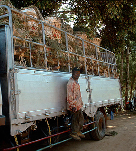
PLATE 1 Farmers in Kwalei village, Lushoto, load up their tomatoes for transport to Dar es Salaam
PLATE 2 Metallic hook used to trap mole rats in Areka
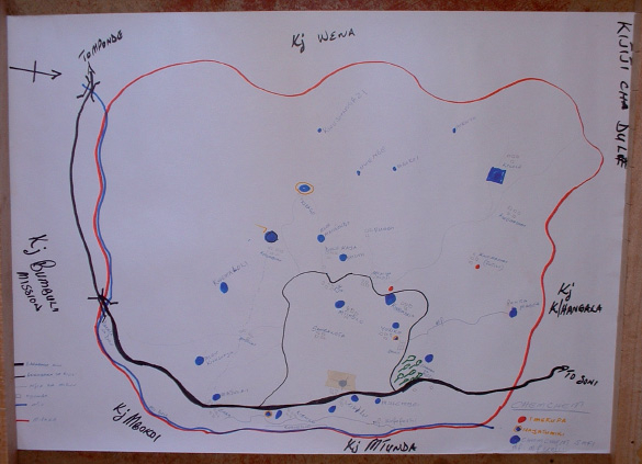
PLATE 3 Participatory map showing locations of year-round (blue dots), seasonal (circled blue dots), and extinct (red dots) springs in Dule village, Lushoto, Tanzania
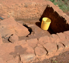
PLATE 4 Spring in Kwekitui Village, Lushoto, which yields much less water today than in the past
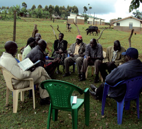
PLATE 5 Tolil Watershed Committee in Kapchorwa, Uganda
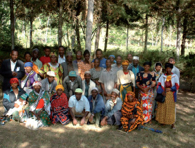
PLATE 6 Village representatives involved in participatory watershed planning in Lushoto, Tanzania
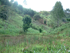
PLATE 7 Progressive clearing of forest and absence of soil and water conservation activities in the catchment and riparian zone just upstream of the Sakharani Mission are believed to have caused sharp declines in the Mission's water supply in recent years

PLATE 8 Introduction to the watershed approach to farmers in Rwanda

PLATE 9 Seeing is believing: water and sediment collection chambers in Ginchi BMS make the extent of soil loss visible to farmers
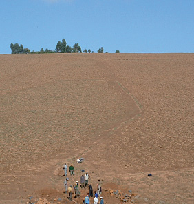
PLATE 10 Ginchi landscape prior to soil conservation interventions
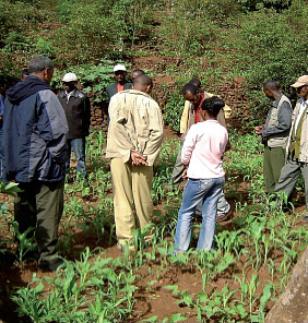
PLATE 11 Ginchi farmers exploring terraced landscape at Konso
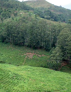
PLATE 12 Farmers in Lushoto complain that eucalypts, such as those lining this tea estate boundary, lead to the drying of nearby springs
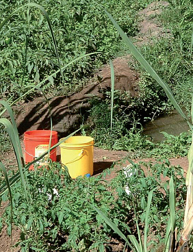
PLATE 13 Cultivation up to the edge of a spring in the Baga watershed, Lushoto

PLATE 14 Landscape with (bottom) and without (top) natural resource governance
Lessons learned
The following lessons were derived from AHI experiences with participatory M&E:
• Participatory M&E at multiple levels (community, R&D team) is instrumental in ensuring any change process is successful, given the need to proactively reflect on challenges faced and the approaches being used to address these challenges or reach the agreed end goal.
• Stakeholder-based processes for participatory M&E at community level can be useful in capturing diverse perspectives on the effectiveness of approaches, and on the winners and losers of any intervention.
• The frequency of community-level participatory M&E events must be adapted to the activity at hand (frequent for tree nurseries, for example, because poor group performance can within days lead to death of seedlings), the stage of implementation (more frequent at early stages, for example, when farmers and team members are beginning to learn how to work together) and the complexity of the challenge (Box 3.21).
• Regular monitoring of the performance of R&D teams with respect to the use of integrated and participatory approaches is essential for ensuring their continued use in practice, given high levels of specialization of disciplines, institutional mandates and mindsets.
BOX 3.21 “DON'T GIVE UP!”: THE IMPORTANCE OF SUSTAINED MONITORING TO ADDRESS CHALLENGES
Perhaps the most challenging watershed activity in all AHI benchmark sites has been to facilitate outfield intensification in the Ginchi benchmark site. The reasons behind this relatively intractable challenge, as described in prior case studies, include low tenure security from histories of land reform and limitations on private property rights, seasons of restricted and open access to private farmland, and limited options for livestock feed. For such a challenging task, R&D teams must work closely with watershed communities to design and redesign innovation strategies, and to monitor their effectiveness in practice. Participatory planning and monitoring highlighted a host of challenges farmers face when struggling to innovate and intensify their outfields. If farmers were to fence outfield plots owned by the household, they would face an insurmountable barrier of sourcing alternative feed, since they would be restricted from accessing the fallowed plots of other farmers and the cultivation of fodder crops would compete with food crops. Collective action in reducing free grazing was also seen as inviable given that many livestock come from distant villages and fostering collective action at that scale is nearly impossible. Farmers finally agreed to construct soil bunds, plant soil stabilizers along them and manually protect them from livestock damage by guarding the fields and fencing seedlings. This was tested in the 2005 growing season, but since this approach was labor intensive, most of the seedlings were destroyed from grazing livestock (Table 3.15). In the 2006 season, follow-up monitoring and negotiations led farmers to agree to test local by-laws to restrict free grazing in selected sub-catchment areas until conservation bunds and trees were established, and then shift these areas to gradually cover the entire watershed. The agreement also included the testing of new tree species along bunds. While the approach worked during the rainy season (when outfield areas are under cropland or restricted access grazing), it broke down during the dry season when open access grazing is practiced. Follow-up monitoring elucidated farmers’ concern about equity issues—namely, that only those landowners falling within the protected sub-catchment benefiting in the short term from restricted grazing, as well as a strong reluctance to follow through with agreements.
TABLE 3.15 Seedling performance under diverse outfield intensification strategies
|
|
% seedling survival by species |
|
Season |
Species |
End of rainy season |
End of dry season |
Jun 05—May 06 |
Chamacytisus palmensis |
83 |
2.3 |
|
Acacia decurrens |
68 |
1.8 |
Jun 06—May 07 |
Chamacytisus palmensis |
92 |
0.5 |
|
Vetiveria zizanioides |
98 |
10 |
|
Pennisetum purpureum |
89 |
0 |
Under such extreme challenges, what options remain? One could simply give up, in which case a problem affecting huge portions of Ethiopia where some of the poorest in the world live would remain largely unresolved. Alternatively, one could utilize empirical data showing the linkage between tenure security and levels of farmer investments in sustainable NRM to advocate for structural changes such as improved property rights. While this was something to be considered, it also posed major challenges and would require complementary innovations in the free grazing system in order to bring about changes in land use. The team therefore decided to make one more attempt to solve the problem locally, namely through use of an economic “pull” that might induce outfield innovation. They decided to introduce high-value trees (apple) as an incentive for outfield intensification. The problem faced at the time of writing was that the team failed to make technology delivery conditional on certain types of management (e.g., that they be planted in outfields) and farmers have largely planted seedlings in infield plots. So the question remains as to whether this will be a viable option for inducing outfield innovation in the Ginchi site, or whether other options such as strong enforcement of local resolutions might also work. The “take home” messages from this case study are: (i) ensure and build on early successes so that farmer engagement with tough challenges can be sustained; (ii) frequent monitoring of local and scientific indicators can be useful for guiding new approaches; and (iii) “don't give up” when addressing tough watershed challenges!
Addressing implementation challenges
Timely monitoring at all levels can go a long way in increasing the chances of success in watershed management. However, it is also useful to acknowledge that some challenges are likely to arise under the best of monitoring systems, and to explore what AHI has learned in our efforts to address them. A few key challenges stand out and merit specific attention here.
Approach development
In this section, approaches are presented according to the nature of key challenges faced.
Challenge 1—Overcoming historical and “structural” constraints
A number of challenges faced in participatory landscape-level innovation emerge from historical or higher-level “structural” constraints. Historical constraints have included legacies from the colonial era in British East Africa, where conservation methods were enforced from above through violent means. This entrenched a very negative attitude in people's minds towards soil conservation. In an act of defiance, all structures were systematically destroyed at independence. In Ethiopia, histories of land reform and shifting land tenure policies through feudal, socialist, and contemporary eras have instilled a sense of tenure insecurity in the minds of farmers, causing them to resist any conservation investments in the less secure outfield areas. While the government promises no future land reforms, the experience of shifting governance systems overrides any security farmers may feel over land rights. Land insecurity resulting from de-gazettement of protected areas for resettlement of prior indigenous residents has created similar problems of tenure insecurity in the Kapchorwa site, undermining land investments. Approaches to break through the cognitive and psychological barriers to innovation are often needed to help overcome such entrenched, historically grounded attitudes posing barriers to innovation (Box 3.22).
BOX 3.22 SEEING IS BELIEVING: THE IMPORTANCE OF CROSS-SITE VISITS IN EXPANDING FARMERS’ MENTAL MODELS ON “WHAT IS POSSIBLE”
At times, farmers’ understanding of “what could be” is largely constrained by “what is.” The landscape in Ginchi and much of highland Ethiopia is almost devoid of trees, and biomass and enterprise diversity is extremely low (see Plate 10). For farmers to imagine a conserved landscape with controlled grazing and diverse crop and tree enterprises requires a very big leap of the imagination. Field visits to Konso, where terraced landscapes and a diversity of enterprises at plot and farm level are the norm, opened farmers’ eyes to “what could be” (see Plate 11). As stated by Atu Yirga Tafu, a Ginchi farmer, “If I had not been to this place I would not have believed human beings can construct the whole district in such an artistic manner.” Others expressed their surprise at the number of crops they were unfamiliar with and the number of different crops growing in a single plot.
Other historical constraints have included failed development efforts from past administrations or projects, making farmers reluctant to trust outside actors. Hand-outs used by past or concurrent projects and histories of aid (food and cash for work programs) have inculcated a “dependency syndrome” in some sites (Areka, Kabale), undermining voluntary contributions by farmers and causing farmers to focus on “quick fixes” rather than more comprehensive development strategies. In some cases, traditional norms and beliefs hinder effective solutions, as in the aforementioned case of communal grazing areas in Areka or the case of male-dominated decision-making, land tenure and management of household finances in much of the region.
Structural constraints are those factors largely beyond the control of communities which nevertheless influence the extent to which problems may be readily solved. Such structural constraints included national policies (i.e., government land tenure in Ethiopia, which has a similar effect on farmers’ willingness to invest in their land as prior government appropriation of land during land reform programs), poor market opportunities and infrastructure which make agriculture less profitable than other livelihood options, and institutional practice which undermines equitable and effective development. Examples of such institutional practices included a bias toward wealthy male farmers in many agricultural extension programs, failure of research and development organizations and different sectors to work in partnership, and the demonization of indigenous knowledge, beliefs, and behaviors through modernization and its institutions (religious, educational, agricultural, etc.). A final institutional constraint emerged from efforts to step outside standard institutional mandates to embrace broader dimensions of NRM based on the “integration” concept, as observed by the Holetta Agricultural Research Centre (HARC) when using spring development as a watershed entry point (Box 3.23).
BOX 3.23 ADMINISTRATIVE HURDLES FACED WHEN STEPPING OUTSIDE SECTORAL MANDATES
The participatory approach to watershed diagnosis challenged AHI partners— largely agricultural research and extension organizations—to step outside their normal institutional mandates. The compartmentalized nature of institutional mandates caused a host of bureaucratic challenges. When proposing to use spring construction as an entry point for watershed interventions—to raise farmer confidence in AHI and catalyze their interest in other water-conserving catchment management practices—research center officials (administrators, finance heads, and auditors) expressed concern. Their main reservation was that HARC has no mandate to carry out such construction activities without the knowledge and permission of the engineering department within their umbrella organization, the Ethiopian Institute of Agricultural Research (EIAR). Because of this, HARC requested EIAR for their endorsement of and support to spring construction. Being the first time EIAR and its engineering department had receive such a request, they were unsure how to respond. They raised questions such as:
1. Do construction works for spring management fall within the mandate of agricultural research?
2. Since the springs along with the construction materials will be handed over to the community and Bureau of Water Resources, how will they be registered? Will this create a problem for official transfer of property and for internal audits?
These complexities forced the site coordinator to make frequent trips (about 10 in all) to Addis Ababa to convince officials of the need to support this activity, and to follow through with the diverse administrative procedures. Finally, by presenting coherent arguments for the logic of spring construction in the context of integrated watershed management, Deputy Director Generals for Research and Administration approved the request.
While a more logical approach would be to reach out to ministries with a relevant mandate, this was ineffective as the selected watershed site fell outside their priority areas of operation (largely urban). This case study therefore shows that agricultural research and development agencies must be in a position to reach out to district partners and expand their institutional mandates when engaging in a holistic approach to landscape-level NRM.
Many of these constraints have not been overcome, making progress slow in addressing certain locally felt NRM concerns. However, progress has been made in some areas to either minimize the extent to which these problems hinder solutions, or to address problems despite these hindrances. One prominent example comes from the Ginchi site. Histories of land reforms and public land ownership in the country and traditions of open access grazing in the site have jointly undermined farmer investment in outfields. However, cross-site visits to areas that have been intensified despite the odds have opened farmers’ eyes to what is possible, and increased their enthusiasm for working within these broader constraints to improve their livelihoods by making better use of existing resources. Following feedback meetings to share these discoveries with other watershed residents, enthusiasm was much higher for developing and testing collective solutions to the outfield dilemma. Another example comes from efforts to counter the dependency and apathy resulting from a prolonged history of hand-outs from development actors and top-down decision-making from government. Continuous efforts to facilitate farmers to think for themselves and solve their own problems have changed farmers’ attitudes, boosted their confidence in working collectively on their problems, increased their willingness to experiment and, ultimately, improved their livelihoods. Challenges remain, however, in finding a suitable institutional model for sustaining such heavy facilitation efforts. Closer partnerships between research and development institutions and training of community facilitators at the local level are promising options.
Challenge 2—Managing complexity
Managing landscape-level processes in an integrated and participatory manner is a complex task. AHI's approach went beyond soil and water management to encompass agroforestry, crop and livestock production, water management for domestic purposes (water harvesting, spring protection), energy, markets, and the social and governance dimensions of each of these. Since farmers had an interest in each of these areas, many activities were ongoing at any given time. Some activities also had to be aligned with the seasons, requiring rigid implementation schedules. This was at times hindered by slow administrative procedures within R&D organizations and limited availability of required materials (i.e., seedlings of certain tree species), among other factors. Social, economic, and political life outside agriculture is also rich in rural communities, with many activities competing for farmers’ time. Learning how to sequence, coordinate, and harmonize activities in time and space given each of these factors is challenging. Very detailed and consultative planning at the outset, including activities to be conducted, their timing and well-defined roles and responsibilities can assist in this regard, as can frequent replanning to adjust actions with emerging realities. One challenge which is difficult to overcome was the tendency for development processes to be embedded within projects of short duration and overly influenced by external institutional mandates. While landscape-level NRM takes time, periods of donor funding were limited to a few years at a time. The implication is that it is important to set realistic plans with donors in terms of the time required for any given change process to unfold and to bring significant impact. Time horizons must be set on the basis of whether methods are to be adopted from elsewhere and simply applied, or whether the project aims to engage in a process of action research and methodological innovation—which takes considerably longer. If the former, we estimate that 3 to 5 years may be sufficient if facilitators are adequately experienced and thus able to quickly gain rapport with farmers, and if they receive prior training in INRM approaches.
The participatory nature of the watershed management approach used by AHI also required strategic balancing of attention to activities bringing short- and long-term benefits to community members. First, in contexts characterized by high levels of rural poverty, NRM strategies needed to be grounded in immediate livelihood concerns such as food security. Thus, efforts to address NRM challenges bringing only medium- or long-term benefits required that interventions be accompanied by strategies to address the immediate needs of farmers. Second, no extended periods of time should pass without farmers seeing any benefit from watershed management activities so as to sustain their interest. If approaches used for watershed exploration took time, for example, it was necessary to identify and apply entry points based on identified priorities of farmers to sustain community interest and build trust. Since some activities take many years for benefits to be seen (e.g., soil fertility improvements through reduced erosion, groundwater recharge from conservation structures and niche-compatible trees), the concurrent implementation of activities with short-, medium- and long-term benefits is required. In AHI sites, activities with short-term benefits (e.g., spring protection, dissemination of proven varieties) were conducted alongside activities with benefits derived over the medium-term (e.g., technology and by-laws for nichecompatible agroforestry) and long-term (e.g., soil and water conservation).
Another dimension of complexity emanated from efforts to work in teams with people from different institutional, sectoral, and disciplinary backgrounds through team work and partnerships. Different disciplines working in R&D teams, for example, had different views on the meaning of watershed management and strategies to be used. The tendency to “disintegrate” into areas of disciplinary expertise was strong and had to be continuously reflected upon as a team and addressed for teams to come together toward integrated solutions. This extended down into the specific research questions and variables to be tracked by researchers, who tended to focus on research questions, methods and variables from within their own areas of expertise rather than integrated research protocols. This problem extended to the participatory nature of research, which should ensure farmers’ priority variables (which tend to cut across disciplinary boundaries) are brought on board within formal and action research. Strategies that helped to overcome these barriers to more effective collaboration included regular review and planning meetings to reflect on the approach being used, participatory monitoring with farmers, and an official “policy” within AHI to work through partnerships and interdisciplinary teams.
Challenge 3—Social justice and equity
A final area that presented substantial challenges was in managing equitable approaches to participatory landscape-level innovation. This challenges stems from both the realities on the ground and the approaches used to bring change. Highly polarized local interests in NRM make natural resource management a political process in terms of who wins and who loses from current land-use practices and related innovations. The challenge lies in bringing solutions that benefit multiple parties at the same time, or maximize the benefits for most land users while minimizing the cost to any given party. External institutions often have a role in favoring some local land users over others owing to their failure to consider equity and monitor effects on different local groups. These issues will be discussed in greater detail in Chapter 4.
Lessons learned
The following lessons were distilled from efforts to address challenges that arise through implementation:
• Constraints emanating from historical and “structural” influences at higher levels may at times represent significant constraints to INRM.
• The dependency syndrome and negative attitudes stemming from past experience can be overcome, but it requires continuous sensitization (most notably, through cross-site visits, see Box 3.22), dialogue and observing concrete improvements among early innovators.
• Multidisciplinary teams do not ensure interdisciplinary approaches. It is easier for diverse research disciplines to work toward disciplinary aims when on multidisciplinary teams than to work toward integrated solutions. Sensitization and frequent reflection meetings at the level of R&D teams are necessary (but not sufficient) to overcome disciplinary barriers to interdisciplinary team work and integrated approaches. Political support and performance review systems that reward multidisciplinary approaches and results are also important.
• Agricultural research mandates focusing more on research than on development concerns, and having a narrow productivity focus, hinder action research and integrated approaches to addressing landscape-level problems.
• Achieving equitable solutions to landscape-level NRM requires fostering synergies between governance and technological interventions. It also requires behavioral change among external R&D actors in the way they interface with rural communities (to proactively avoid elite capture and foster equitable benefits capture) and monitor outcomes (so as to capture socially differentiated effects). Additional details on the empirical basis for this lesson may be found in Chapter 4.
• Frequent monitoring and replanning at local and R&D team levels is of fundamental importance to adaptive learning in addressing complex NRM challenges.
Missing links
Addressing landscape-level livelihood and natural resource management concerns of farmers is a challenging task. Substantial progress has been made by AHI in the eastern African highlands in identifying approaches to operationalize participatory landscape-level innovation, including methods for participatory problem diagnosis and prioritization, participatory planning, and participatory management of change (including monitoring and adjustment). Scientific methods to support these processes have also been articulated and refined, including setting baselines for subsequent impact assessment, delineating and characterizing watersheds (methods developed largely outside of AHI but refined internally), embedding scientific research in locally owned change processes, and supporting local change through facilitation and support in addressing common implementation challenges. However, there are a number of methodological gaps for coming full circle in our efforts to operationalize participatory landscape-level innovation. These gaps highlight a number of priorities for future research and methodological innovation in AHI and the region at large.
1. “Minimalist” approach to watershed characterization. While all of the data collected during the watershed characterization was useful to researchers, who may generate ample material for publications, not all of it is directly relevant to planning, monitoring, or impact assessment. This approach can be simplified so that the minimum data needed to identify opportunities, develop strategies, and monitor performance is collected at this time. This can minimize farmer “fatigue” and make more efficient use of financial and human resources.
2. Hybrid approach to participatory watershed diagnosis and planning. Different approaches employed for participatory watershed diagnosis, prioritization, and planning each had their respective strengths and weaknesses. It is likely that “hybrid” approaches building on the strengths of each will be better than any of these approaches in isolation, and efforts should be dedicated to testing such approaches in practice.
3. Sequencing of steps in R&D team planning for landscape integration. As integrated R&D protocols are developed at the level of R&D teams, they need to be continuously informed by participatory decision-making processes involving the intended beneficiaries. This is done not only through participatory planning around previously identified watershed problems, but also by continuously cross-checking assumptions about the most relevant causal processes to serve as the organizing logic for clustering, the most appropriate approaches for community facilitation and the most critical research questions. For example, while biophysical scientists and extension practitioners may emphasize a biophysical logic for clustering, farmers may use different rationales for clustering focusing on social or economic processes. Local residents may also perceive different research priorities than researchers, based on what they know to be critical gaps in their knowledge base. Beneficiary groups and communities should increasingly assume decision authority as the range of possible meanings and uses of “research” come to light and as local capacities to design and monitor change processes are improved. More research is needed on how to effectively sequence participatory, community-level planning with planning at the level of R&D teams. Ultimately, the latter should build upon (during the design phase) and support (during implementation and synthesis of lessons) community-level objectives and decision-making.
4. Participatory approach to generating functional R&D clusters. Another knowledge gap in the planning stage is the extent to which the creation of functional R&D clusters can be made a fully participatory activity with communities. This would go a long way in addressing the aforementioned sequencing issues in R&D team planning. To what extent can farmers develop, with minimal external assistance from research and development actors, fully integrated action plans at watershed levels that foster “win–wins” in livelihood and environment, and optimal returns to different social actors (based on gender, wealth, ethnicity, or specific sets of interests vis-à-vis what is being planned)? What is the optimal distribution of planning responsibilities between communities and R&D teams? These questions should form the basis of future research and methodological innovation in this area.
5. Testing of integrated solutions to difficult landscape-level challenges. The means to address the multiple challenges of intensification in Ethiopian outfields remains a challenge. Innovative or multifaceted solutions should be explored, including the use of incentives (e.g., conditional delivery of high-value crops and trees, payments for environmental services, among others), regulations (e.g., policies to control livestock movement, support the implementation of local agreements, or link incentives to specific problem niches), and institutional innovations (e.g., fostering collective action at higher levels, privatization of tenure conditional on good land management, innovations within support agencies). Multidisciplinary and multi-institutional teams with a strong sense of dedication to the process are an essential component, as are “systems thinkers” (from both the community and the facilitation team) who can help to think outside the box.
6. Adaptive testing of proven approaches in other highland sites and agro-ecological zones. While methods already developed within AHI have only been field-tested in the eastern African highlands, they are likely to be of wider applicability as they were generated in multiple contexts and address challenges that are widespread. This suggests that the methods are likely to be relevant to other highland areas throughout the tropics and, for some issues, perhaps also other eco-regions (e.g., densely settled lowlands). A missing link which is likely to yield high returns with limited effort is therefore the adaptive testing and modification of these methods in new settings. We welcome opportunities to partner with other R&D actors within the region and elsewhere to expand the learning process in this regard.
Conclusions
This chapter illustrates a sequential series of methodologies for facilitating a process of participatory watershed entry, diagnosis, management, and governance. While the process is complex and challenging, it also yields rich rewards for rural livelihoods, sustainable natural resource management, and more harmonious relationships within densely settled highland communities. While the approaches presented here are ready for uptake by other organizations, there is need for more experimentation with the various approaches presented—so that strategies may be refined to meet the unique circumstances of different countries and localities. And, as always with any sort of methodological or institutional innovation, pilot first and scale up later!! Only with such experimentation can the necessary lessons be learned that will enable programs to avoid propagating errors and instead disseminate methods proven to work in a variety of settings.
Notes
1 These included farmers with prior involvement in NRM Task Forces supported through prior efforts of CIAT and AHI in Rubaya Sub-County, Watershed Management Committees who had worked with Africare in Hamurwa Sub-County, soil conservation groups who had worked with NEMA in Bubaare and individuals from new villages with severe environmental problems.
2 In two sub-counties where villages were closer to one another, the village-level NRMPCs decided to form higher-level coalitions to work jointly on common NRM challenges, electing smaller committees to coordinate work across several villages.
3 In some AHI benchmark sites, there is no such distinction between upslope and downslope households, either because most farmers hold land in different parts of the landscape or because the landholdings of different households are arranged in strips from the hilltop to valley bottom. In villages where some farmers hold land in multiple landscape locations while others hold land in only one locations (e.g., upslope or downslope), farmers whose perspectives are likely to be most different from other households—in this case, with plots restricted to single landscape locations—are called together for consultation.
4 Focus group discussions are less time consuming than household surveys for ranking watershed priorities. However, individual ranking ensures that diverse views are better captured, as dominant individuals will always influence what final number is put on paper.
5 A key gap in AHI methods development is in the testing of such “clustering” methods at community level to see to what extent fully integrated watershed action plans can be generated with minimal outside assistance. This should constitute a priority for future R&D interventions.
6 Issues denoted by parentheses are those that would be only partially addressed through interventions focused on the cluster of issues, because they are partially the result of issues beyond local control.
7 Clearly, the identification of such functional clusters requires a relatively intimate knowledge of the system. It is important to note that this knowledge can be provided by either farmers or researchers who have been working in the system in a participatory manner for some time. We would encourage the exploration of both options when applying this methodology in new sites.
References
Ashby, J.A., J.A. Sanz, E.B. Knapp and A. Imbach (1999) CIAT's Research on Hillside Environments in Central America. Mountain Research and Development 19(3): 2–18.
Bellamy, J.A., G.T. McDonald and G.J. Syme (1998) Evaluating Integrated Resource Management. Society & Natural Resources 12: 337–53.
Chambers, R. (1994) Participatory rural appraisal: Analysis of experience. World Development 22(9): 1253–1268.
Constantz, G. (2000) Grassroots-based Watershed Conservation in Central Appalachia. Mountain Research and Development 20(2):122–25.
Datta, S.K. and K.J. Virgo (1998) Towards Sustainable Watershed Development through People's Participation: Lessons from the Lesser Himalaya, Uttar Pradesh, India. Mountain Research and Development 18(3): 213–33. FAO-UNESCO (1987) Soils of the World. Food and Agriculture Organization and United Nations Educational, Scientific and Cultural Organization, New York: Elsevier Science.
De, R. and S.P. Singh (1999) Watershed Development Imperatives for Boosting Rainfed Agricultural Productivity – An Indian Experience. New Delhi: Indian Council of Agricultural Research.
German, L. (2006) Moving beyond component research in mountain regions: Operationalizing systems integration at farm and landscape scale. Journal of Mountain Science 3(4): 287–304.
German, L. and A. Stroud (2004) Social learning in regional R&D programs. AHI Brief D2.
German, L., S. Charamila, and T. Tolera (2006a) Managing trade-offs in agroforestry: From conflict to collaboration in natural resource management. AHI Working Papers No. 10.
German, L., B. Kidane, and R. Shemdoe (2006b) Social and environmental trade-offs in tree species selection: A methodology for identifying niche incompatibilities in agroforestry. Environment, Development and Sustainability 8: 535–552.
German, L., S. Ayele, W. Mazengia, M. Tsegaye, K. Abera, K. Bedane, E. Geta, T. Tolera, and H. Taye (2008) Institutional Foundations of Agricultural Development in Ethiopia: Drawing Lessons from Current Practice for Agricultural R&D. Quarterly Journal of International Agriculture 47(3): 191–216.
Knox, A., B. Swallow and N. Johnson (2001) Conceptual and Methodological Lessons for Improving Watershed Management and Research. CAPRi Policy Brief 3: 1–4.
Johnson, N., H.M. Ravnborg, O. Westermann and K. Probst (2001) User Participation in Watershed Management and Research. CAPRi Working Paper 19: 1–25.
Mowo, J.G., L. German and T. Tolera (2006) Local institutions and their role in INRM: A regional synthesis. In: T. Amede, L. German, C. Opondo, S. Rao and A. Stroud (eds), Integrated Natural Resources Management in Practice. Enabling communities to improve mountain livelihoods and landscapes. Proceedings of a conference held at ICRAF HQ, Nairobi Kenya October 12–15 2004, African Highlands Initiative; Kampala Uganda.
Pirrie, A., V. Wilson, J. Elsegood, J. Hall, S. Hamilton, R. Harden, D. Lee and J. Stead (1998) Evaluating Multidisciplinary Education in Health Care. Edinburgh: SCRE.
Ravnborg, H.M. and J.A. Ashby (1996) Organising for Local-Level Watershed Management: Lessons from Rio Cabuyal Watershed, Colombia. AgREN Network Paper 65, 14.
Rhoades, R. (2000) The Participatory Multipurpose Watershed Project: Nature's Salvation or Schumacher's Nightmare? In: L. Rattan (ed.) Integrated Watershed Management in the Global Ecosystem. London: CRC Press, pp. 327–43.
Rietbergen-McCracken, J. and D. Narayan, comps. (1998) Participation and Social Assessment: Tools and Techniques. Washington, D.C.: World Bank.
Schubert, W.D., Klukas, O., Saenger, W., Witt, H.T., Fromme, P., and Krauss, N. (1998) A common ancestor for oxygenic and anoxygenic photosynthetic systems: a comparison based on the structural model of photosystem I. J Mol Biol 280: 297–314.
Shah, A. (1998) Watershed Development Programmes in India: Emerging Issues for Environment-Development Perspectives. Economic and Political Weekly, June 27, 1998, A66–A78.
Stroud, A. (2003) Combining science with participation: Learning locally and generalizing regionally. AHI Brief B3.
Turton, C. and J. Farrington (1998) Enhancing Rural Livelihoods through Participatory Watershed Development in India. ODI Natural Resource Perspectives 34: 1–4.
Van Horen, B. (2001) Developing Community-Based Watershed Management in Greater São Paulo: The Case of Santo André. Environment & Urbanization 13(1): 209–22.