13
Smart Cities and Security of Critical Space Infrastructure Systems
13.1 Introduction
It is challenging to completely comprehend the current security risks to space systems due to a shortage of academic study in the area and the frequent secrecy around or classification of information concerning events harming vital infrastructure. Nevertheless, the literature in the field has highlighted the following vulnerabilities (Botezatu 2022):
- Remote sensing is gathering information about a research topic without directly contacting them. These devices are especially susceptible to laser assaults because electromagnetic weapons might be used to accomplish their primary goal.
- Communications satellites are necessary for aircraft and long-distance connections due to the planet’s curvature impeding the line of sight. The destruction of these links might lead to a huge loss of life on Earth. According to studies, the Earth component of the satellite communications infrastructure is particularly susceptible to online assaults like jamming and spoofing (Steinberger 2008).
- Meteorological space facilities are essential for missions like forecasting severe weather. These satellites are frequently created only to send pictures and meteorological data to Earth. There isn’t much published research on the vulnerabilities of meteorological satellites, but at a minimum, they probably have at least the same problems as other satellite systems.
- The Global Positioning System (GPS) and other satellite technologies are part of the Global Navigation Satellite System (GNSS). Jamming and spoofing are the two main ways GNSS is exposed by the literature (Faria et al. 2016; Ioannides et al. 2016).
13.2 Critical Space Infrastructure and Smart Cities
Space is very complex from a myriad of perspectives. First, the environment behaves differently. For example, laws governing motion and forces in space are different from ground systems. The rules of celestial mechanics make the space environment much more complex than what we have on the ground. Secondly, the uses of space are multiple. Initially referred to as dual-use technologies, the space infrastructures and services serve a multitude of actors, bluntly split among civil and military, but much more complex than that, ranging from governmental users to commercial ones. Lastly, different uses lead to various actors, institutions, and legislative framework constellations. These delineations of actors might not be equally valid in the cities on the ground. In scarce situations, the militaries are involved in smart city operations. Control rooms are managed by public–private entities, with security personnel when needed.
As opposed to any other finite surface on Earth, outer space is endless. Thus, any operation planning is different than on the ground. As an analogy, Earth’s oceans contain 329 million cubic miles of water on and below the planet’s surface. The volume of space between Earth and the Moon is 4.81097E+16 cubic miles. To achieve a comfortable degree of space control, one has to “control” 146,230,091 times the volume of Earth’s oceans. It sounds like an impossible task, at least for the current level of development, since there aren’t any geographic features in space. However, satellites cannot hide from Earth- or space-based sensor networks. And yet real satellites are “lost” all the time. For instance, in a satellite catalog published by the 18th Space Defense Squadron (Mattern 2021), nearly half of all space objects are classified as “Analyst Objects,” meaning it is unknown what they are and who owns them. In addition, there are many means of hiding satellites in space. An additional problem is fully identifying the targets for space weapon systems. Moreover, even objects that are cataloged and tracked near a collision (less than 500 m) can sometimes get overlooked, as in the Iridium 33 collision with Cosmos 2251. Finally, there are so many pieces of uncatalogued debris in outer space that the space is obscured.
13.2.1 Responsible Actions in Space and Smart City Governance
While, according to the current international law, responsible actions in space are the prerogative of nation-states, and smart city governance requires a local-level approach, this research is attempting to make this connection visible (Botezatu 2022). Undoubtedly, the information and services offered by space technology are crucial to the success of smart cities. However, the specifics of this complex relationship and the degree of this dependency are the main subjects of this study. The capacity to describe the space environment and activities is known as space situational awareness (SSA), which entails monitoring space objects using both ground- and space-based sensors, such as radars or optical telescopes. The orbits of space objects are ascertained and future courses are predicted using a combination of tracking data from various sensors. Characterizing space objects, space weather, and pre-planned on-orbit operations are other crucial SSA elements.
Even though certain nations perform activities that may be categorized as space traffic management, there are presently no well-established international frameworks or common state practices (STM). The US government launched a program in 2010 to notify all satellite operators when an object is approaching them closely. Soon after, a few additional countries joined in and sent identical warnings to satellite providers. To improve the vital warnings and information governments provide, several satellite operators work with a third-party service, such as the Space Data Association (SDA) or their own national space agency. Additionally, studies have looked at the relationships between space aviation traffic and potential safety issues, and there have been worldwide political movements to look into voluntary laws or norms for enhancing the sustainability and safety of space operations. There is now no international framework to regulate space flight since, as far as these authors are aware, no study has been conducted that shows the importance of high politics to local politics. Although smart city governance can connect the population to the urban realms of decision-making, there remains a lack of connection to rural realms of decision-making. The rural realms are often unmanaged and left invisible.
13.2.2 Natural Threats from Space and Their Effects on Smart City Infrastructure
Those space assets currently in use are at risk of various dangers, such as collisions with space debris and the total amount of energy unleashed by space weather events. Over the last twenty-five years, multiple models for the causal chains connecting solar, wind, and geomagnetic disturbances, geomagnetic induced currents, and the sensitivity of the electrical grid have been investigated.
In the early 1990s, people began considering how space weather may affect the electricity system. Engineers at energy provider Hydro Quebec attributed the failure of their power grid in March 1989 to unusual solar activity (Australian Space Weather Forecasting Centre 2022). Six million people in Quebec were without power for more than nine hours due to the transformers’ gradual failure and the electrical system’s final collapse. The planet’s first recognized geomagnetic storm reignited research into how the geomagnetic currents created influence activities on Earth. The incident clarified how crucial solar weather is to all ground-based electrical conductor systems, including pipeline, railroad, and telephone networks. Critical infrastructures in smart cities that rely on space-based assets may have issues during an electromagnetic storm. Many other types of damage might occur, so it is important to consider the storm’s severity, timing, and geographic dispersion (CENTRA Technologies 2011). Relevant research has stressed the following effects to offer a framework for organizing the development of resilient systems.
A solar storm begins when one or more complex sunspot clusters are visible across the whole solar surface. One or more solar flares from these active regions might be seen on Earth eight minutes later utilizing radio, optical, and x-ray wavelengths. Extremely intense solar particles are then blasted at satellites and ground systems over a period of hours to days. During these stages, critical ground infrastructures from smart cities might experience significant repercussions and possibly damage, either directly, as with satellites, or indirectly as a consequence of cascade failures. Figure 13.1 depicts an array of infrastructure systems that could be affected in the case of solar storms (IFP Energies Nouvelles 2018).

Figure 13.1 Elements of a smart city that could be affected by solar storms. Source: Adobe Stock
Satellites, airplanes, and power grids are among the technological infrastructure systems that are impacted by space weather occurrences. The contemporary economy is particularly vulnerable to solar storms due to a web of interdependencies. Thus, critical goals are improving our understanding of the root causes of space weather and our capacity to anticipate it.
Impacts on the urban electrical power grid: the geomagnetic storm has the potential to damage several significant facilities. Due to conductors on the earth’s surface acting as conduits for geomagnetic generated currents (GICs), electrical power networks are particularly susceptible. These GICs cause systemic issues by moving through the pipes and wires that make up the power transmission networks. Overloading the grid with GICs might cause major voltage control problems and even widespread power outages. Extra-high voltage transformers heated inside by GICs are also more prone to failure or perhaps irreparable harm (National Research Council 2008). Since the total collapse of the energy system would be such a catastrophic event for the people, infrastructure sectors, and trust in authorities, many more studies have concentrated on this probable course of action. According to a study by the North American Electric Reliability Corporation (2010), the geomagnetic hazard environment’s potential extremes may be far more significant than previously believed. In fact, a one-in-one-hundred-year incident may lead the United States to face a catastrophic system failure that would take several years and billions of dollars to fix, according to Kappenman (2010). However, recent discussions indicate that voltage instability and a reduction in reactive power would likely be the consequences (North American Electric Reliability Corporation 2012). Additionally, during a solar storm, GICs may develop on extensive lengths of earthed electrical conducting material. In summary, disruption of the electrical grid caused by solar storms could impact smart cities very seriously. Table 13.1 indicates the number of confirmed orbital collisions involving active satellites. These dangers cannot be mitigated as solar weather is a natural phenomenon. Nevertheless, built-in resilience plays a fundamental role in withstanding such major disruption.
Table 13.1 Estimated debris in orbital.
| Debris size | |||
|---|---|---|---|
| 0.1–1 cm |
| >10 cm | |
| Total debris at all altitudes | 150 million | 750,000 | 22,000 |
| Debris in LEO | 16 million | 370,000 | 14,000 |
| Debris from the Chinese ASAT | 2 million | 150,000 | 2,500 |
Radiation impacts on all satellite services: certain satellites may malfunction as a result of geomagnetic storms. According to the satellite’s architecture, the rising microelectronic upset rates and the resulting electrostatic charging dangers may result in varying degrees of failure. For satellites in Geosynchronous Earth Orbit (GEO) and Medium Earth Orbit (MEO), Earth’s outer radiation belt poses a particular threat due to the frequent irregularities and outages caused by electrostatic buildup and discharge. Satellites provide a wide array of critical services that keep smart cities’ applications functioning, such as communication, positioning, navigation and timing, and Earth observation. The optoelectronic parts of the spacecraft, particularly the solar cells that power it, are subject to more disruption in the event of a solar storm. A day following the arrival of the Coronary Mass Ejection (CME), radiation levels would also sharply rise, creating internal charging risks that would endure for weeks. Finally, the satellite will see a sharp rise in cumulative radiation damage (Cannon 2013). For instance, the geomagnetic storm of 2003 affected 10% of the world’s satellites. It resulted in brief outages that lasted up to a few days, with older satellites needing to be replaced. Figure 13.2 depicts a list of significant satellite outages and their effect on ground technologies (Cannon 2013).

Figure 13.2 Space weather satellite attributed outages and effects.
Impact on radio communication systems: during a space-weather event, mobile satellite communication may stop working altogether or provide weak performance. High-frequency radio communications will also likely stop working after a few days. If such a geomagnetic storm occurs, emergency communications may become inoperable. Secondary impacts, like loss of power and GNSS timing, might be problematic for terrestrial broadcasting.
Impacts on transoceanic communications cables: the geomagnetic event of March 1989 provided evidence that GICs may damage the cables that accompany the transoceanic fibers of the global communication network (Cannon 2013). It is crucial for these optical fiber cables to be constructed more sturdily since they transport most Internet and telephone traffic in addition to satellite communication (Georgescu et al. 2019).
Impact on urban transportation: solar storms might have varying effects on the transportation industry. On the one hand, a geomagnetic storm might result in greater radiation exposure for passengers and personnel on board aircraft. High-energy solar and cosmic ray particles are produced in vast numbers by nuclear reactions in the upper atmosphere as they travel toward Earth. Additionally, these particles generate secondary particles, whose flow peaks at a distance of around 18 km and is subsequently curbed by the atmosphere. At airplane cruising altitudes, the flow of ionizing radiation is approximately three hundred times larger than at sea level (Cannon 2013). The dose may increase a person’s likelihood of acquiring cancer to one in a thousand in the event of a small incidence.
In avionics, electronic equipment may fail because of the intense solar particles’ indirect charge on semiconductor materials. Secondary neutrons and protons are produced at ground level by the movement of solar energy particles (SEPs), which interact with semiconductor materials both on board and on the ground. Very little information is available on how solar energetic particles affect ground infrastructure. As will be underlined in Section 13.3, this is one of the instances when the importance of critical space infrastructures as suppliers of security, or at the very least as instruments for security decision-makers, has become clear. However, electromagnetic storms affect ground transportation systems on different planes. The GNSS system might become partly or totally useless for up to three days. Over many days, there can be multiple eruptions. After around twenty-four hours, the CME’s accompanying plasma particles arrive and disrupt the ionosphere’s electron density across a sizable planet region. These plasma particles result in the ionosphere developing large-scale, wave-like structures (10–1,000 km in size). Critical space infrastructure may experience scintillation from tiny constructions of less than 1 km. Scintillation in the phase critical space infrastructure disrupts the carrier phase and affects the receipt of crucial navigational data messages.
In the case of GNSS for navigation, the positioning and navigation from a single receiver will be considerably affected during the start of a solar event when the ionosphere is strongly perturbed. There may be major mistakes in position reporting since it is unlikely that all satellites will be monitored due to key space infrastructure scintillation. However, extremely severe electron density fluctuations will occur during the main event. There is a good chance that all positional and navigational solutions will be briefly but entirely lost. As a result, it is anticipated that all crucial infrastructures dependent on GNSS systems may malfunction for up to three days.
In summary, the web of interdependencies makes the modern economy especially sensitive to solar storms. Figure 13.3 depicts the overall technological effects of space weather events as suggested by the National Aeronautics and Space Administration (Zell 2015).

Figure 13.3 Overall technological effects of space weather events. Credit: NASA / Public Domain
Although there has been an increase in public awareness of space weather and its possible effects, more research is still required to understand the concerns fully. Most of the research on the impact of space weather on nations, people, and owners and operators of infrastructure focuses on financial harm. However, there are further consequences. For instance, the OECD project on “Future Global Shocks” offered a framework for evaluating the threat of social unrest, which indicates broad dissatisfaction with the political system and manifests itself in unorthodox protest behavior (Renn et al. 2011). One potential underlying cause is identified as having inadequate infrastructure.
13.3 Interdependencies Between Urban Systems and Space Infrastructure
Regarding areas of interdependencies between critical space infrastructures and terrestrial critical or not-so-critical infrastructures that are the backbones of urban settlements, these encompass more or less all-important sectors of society (Katina et al. 2014). Sections 13.3.1–13.3.10 examine how nonfunctioning space-based technologies might affect terrestrial activities and services in smart cities.
13.3.1 Industry
According to the taxonomy of critical infrastructures developed by the European Programme for Critical Infrastructure Protection, two essential infrastructures need to be discussed: infrastructure for the energy sector and for the chemical and nuclear industries. First, the energy infrastructure – electricity, gas, and oil – represents one of the most significant societal sectors on which our existing way of life depends. Numerous other crucial industries, including healthcare, banking, transportation, and food production, are in danger without a steady energy supply.
Space technologies like GNSS are used more often in energy infrastructure to monitor activity and keep an eye on smart grids. A complicated technology, intelligent power distribution needs accurate environmental monitoring given by GNSS and sophisticated interoperability protocols. Additionally, GNSS may monitor water reservoirs, and water flows in hydropower plants and assess the properties of certain energy sources, such as wind. For example, the 2003 power outage along the US East Coast may be an example of how remote sensing and weather satellites can be utilized to monitor environmental conditions in a specific metropolitan region.
Key space infrastructures are inextricably linked to these critical sectors in the chemical and nuclear industries. Because of this, failure indirectly impacts other crucial sectors, including: energy supply; health services; transportation due to the flow of radioactive materials; information and communication technologies (ICT); defense, public order, and national security; and access to food and water.
13.3.2 Finance
Because urban settlements are the true engines of national economies, the banking sector is an essential part of every nation-state that develops at the city level. The financial industry is vital in several ways, including: allocating capital to its most advantageous use; reducing knowledge asymmetry between economic parties; providing tools for balancing supply and demand; and creating a pricing process. To give a coherent large-scale system, the financial infrastructure – which consists of banks, insurance and finance businesses, national treasury and financial agencies, markets, trading platforms, and others – form a network of extensive connections. With space technologies, digital technologies have secured the system’s ideal performance. Any danger, like the 2008 financial crisis (Calida and Katina 2015), may cascade globally due to the interconnectedness of the financial system.
It is crucial to distinguish between direct and indirect dependency concerning the relationship between the financial infrastructure and critical space infrastructures. The former describes physically linked databases and processes in which a service interruption brought on by a faulty power source renders a portion of the system unusable. Additionally, issues with communication satellites might cause problems with the banking system. Similarly, a crippled global navigation system might interfere with worldwide synchronization, leading to catastrophic losses in the financial infrastructure’s ability to function and delays in the financial markets.
Space-based services that are not directly utilized by the constellation of financial systems, such as data gathered by Earth observation satellites that may be used for financial choices by insurance firms, might have an indirect influence. Additionally, the financial industry, which is essential to society, considers the early warning indicators provided by crucial space infrastructures (Krausmann et al. 2014).
13.3.3 Politics
The central government is a critical sector because of how vital it is to the operation of every nation-state. These governmental systems consider a broad range of structures, many of which are used by the public, as well as business, commercial, administrative, or recreational activities. The public administration infrastructure includes postal services, electronic components for identification, databases, access control systems, and CCTV. Satellites provide service tracking, imaging of different operational domains, and data on a nation’s strategic logistics, including information on transport vehicles, critical locations, information and communications networks, demographic identification, and personal data. Thus, in the case of central administration infrastructure, critical space infrastructure is pivotal.
Less important for cities, unless they are city-states (e.g. Singapore) or are situated on borderlines (e.g. US–Mexico), is the acquisition of data on hazardous and inaccessible places and border regions. This data may be gathered via remote sensing for the defense and national security systems. In addition to GNSS services for monitoring cars and suspects or for rescue operations, satellites are indispensable to border control.
13.3.4 Transportation
In a linked world, the movement of resources and people depends on the transportation infrastructure. As transportation infrastructures become more intricate and connected with programs that address coordination, flow, and control issues, space technologies play a crucial role in laying the groundwork for a competitive transportation industry. Infrastructures for navigation and location, as well as those for weather monitoring and communications, are the key space applications employed in this industry.
The coordination and efficiency of logistics that GNSS service offers is vital to aviation, maritime, railways, and road transportation. In the air industry, GNSS services are essential for managing air traffic congestion or passenger- and luggage-related operations. In the case of maritime transportation, the GNSS offers the fastest and most accurate route, thus increasing the efficiency of transport and the trip’s safety. For busy seaports, space infrastructures help to coordinate the movements of large vessels in narrow spaces, as well as automated container placement, pick-up, and the transfer of goods. In the case of road transportation, GNSS is useful for highway surveillance, vehicle location detection, and emergency operations. Equally important, railway transportation uses GNSS to track the movement of locomotives, control delays, and reduce operating costs by automatically adjusting train speed and re-routing rail traffic.
Finally, it is essential to mention the complex interdependencies between space technologies and transport infrastructures, directly or indirectly affecting other critical sectors. This includes the role of telecommunication infrastructures, the close relationship between the transportation and energy sector, and food and health, particularly in disease outbreaks and their spread across geographical space.
13.3.5 ICT/Communication
Communication satellites become essential for a city to thrive economically, socially, and culturally as well as to ensure community safety and security. Another complicated satellite constellation, wireless and wired service providers, and other technologies are required to transmit a complex universe of telecommunication and Internet services. Another component of spatial technology is bringing TV and radio information to areas that are not generally linked to landlines and other terrestrial networks. Nearly half of the world’s population, especially in Latin America, Africa, and Asia, is thought to reside in places without broadband networks (Broadband Commission for Digital Development 2013).
Synchronization is crucial for communication applications. Mobile telephony and data networks are able to use GNSS to maintain synchronization, and digital broadband radio uses GPS to ensure that all radio station bits arrive at receivers in sync and with minimal delay.
13.3.6 Water Supply
The water sector is vulnerable to events ranging from contamination with deadly agents to cyberattacks, which may cause many human illnesses or deaths. It is also a key sector especially for critical energy infrastructures and the nuclear industry, not to mention the security of citizens.
Regarding critical space infrastructure, communication satellites might be used for communications. Additionally, Earth observation satellites may be used for water supply, flood control reservoirs, flood predictions, and drinking water reserves. Indirectly, they in turn affect the food supply sector by providing information vital to a nation’s survival.
13.3.7 Food Supply
In the food supply sector, space infrastructures are primarily vital for the production of food (i.e. precision agriculture). With GNSS, farmers can monitor their crops, animals, or aquaculture crops. Even in adverse conditions like rain, dust, or fog, work can be done when visibility is low thank to GPS. Precision agriculture also means a rational and needs-oriented distribution of fertilizers and pesticides and better control of the dispersion of these substances. Space technologies can provide accurate maps of areas – with precise information on crops, road infrastructure, and irrigation systems. Moreover, it can provide data on animal dangers, like outbreaks of diseases caused by particular viruses.
13.3.8 Healthcare Services
Healthcare is essential for a society’s well-being because of its involvement in both the prevention and treatment of infectious disease epidemics as well as the response to
natural catastrophes (Katina et al. 2014). The networks of healthcare institutions are heavily reliant on other infrastructures, including information and telecommunications, administrative infrastructures, defense and national security, energy, food and water supply, and transportation, even when individual assets are handled locally (Karthikeyan et al. 2023).
There are interconnections between these crucial industries and space infrastructures. These involve how GNSS and GISs (geographic information systems) may manage disasters and identify air, water, and soil pollution (Katina and Gheorghe 2023). Additionally, space technologies are essential for tracking the spread of diseases during epidemics. By exploiting the localization capabilities of GPS and ensuring a timely reaction, correlated data among police, fire, and medical personnel may help save lives in the event of calamities.
Telemedicine, made possible by GIS and communication satellites, offers fresh approaches to enhancing human health. Healthcare may be provided remotely in settings with limited resources thanks to two-way communications technology, multimedia, and computer networks. Medical professionals can conduct teleconsultations and tele-diagnostics, and give remote training to share their medical experience – therefore moving the expertise rather than the individuals.
Space goods help to fuse medical data with environmental elements, assisting in the early detection of disease epidemics. Both healthcare practitioners and policy makers may benefit from multivariable interactive GIS maps that are produced by combining hospital admission information and police reports to understand the spread of health and sickness better. Medical applications now use materials and technologies that were first created for space purposes.
Another important subject in the healthcare sector is tele-epidemiology, which uses essential space infrastructure to study the transmission of diseases in humans and animals. Tele-epidemiology combines information from satellite observation and a wide range of diverse domains in the realm of space infrastructure (i.e. physical components like temperature or humidity, biological readings, health data, socioeconomic data, etc.). Space technology allows us to evaluate the mechanisms of the emergence, spread, and transmission of infectious illnesses by first looking at the linkages between climate, environment, and health, and then updating the links between infectious diseases and the habitats in which they occur. The ultimate objective is to provide public health stakeholders with tools, such as risk maps, that will enable them to foresee and monitor epidemics. Tele-epidemiology has space-based uses in emergency care and health monitoring.
13.3.9 Education
Access to education has been effectively increased by satellites especially in underdeveloped regions with little infrastructural development. One of these crucial projects is creating remote learning platforms particularly during emergencies (e.g. the COVID-19 pandemic), to provide access to courses and resources and promote contact among peers who would otherwise be unable to meet in person.
In 1975, India experimented with tele-education utilizing the India National Satellite System to broadcast tele-education and telehealth programs. India deployed the first satellite ever devoted to education in 2004. For elementary, secondary, tertiary, and specialized educational facilities, it provides broadcasts, interactive video conferencing, and web-based lessons. The African Virtual University is a satellite-based remote and e-learning effort that enables sub-Saharan African countries to offer professionals university-level education and specialized training. Similar alliances between satellite service providers and several other organizations have been established in South Africa and Brazil to increase educational accessibility.
13.3.10 Other Areas
Urban farming: the most significant population density is found in urban areas with the biggest regional food production needs. Space-based technology enables “precision agriculture” or “smart farming,” helping urban farmers to effectively handle the financial, environmental, and social issues associated with food production (Gebbers and Adamchuk 2010). One essential component of precision agriculture is GNSS-based autonomous steering of agricultural equipment. Systems for controlling animals and growing specialty crops have both benefited from telemetry. The Earth observation satellite’s thermal, optical, and radar imaging might provide valuable data on crops in a repeatable manner. This imaging might be used for agricultural inventory, watershed level planning, and gathering pertinent data on crop growth conditions (water, carbon, and nitrogen cycles). To boost soil productivity, it is thus valuable to receive and analyze data from several satellite platforms.
Human rights: since it is difficult to investigate and provide reports on human rights breaches, high-resolution satellite images from Earth observation satellite instruments may provide the foundation for such reports. Additionally, geospatial imaging is used particularly by non-governmental organizations (NGOs) to evaluate risks to human security, such as the gradual demolition of settlements, access to resources, and the monitoring of refugees, among others. For example, space-based technology discovered mass graves in Kosovo for the first time in 1999. Images captured from space during the second Chechen War served as proof of war crimes (Lyons 2012). Similarly, satellite images were able to show the international community the location of political jail camps in North Korea and intentional village burning in South Kordofan and Darfur, as well as mass graves (Botezatu 2022; Van 2008).
When gathering on-the-ground information is too risky or politically sensitive, especially in war zones, satellite photography may be utilized to monitor the condition of vital facilities. During the Arab Spring, residents in the impacted nations could communicate through satellite because they had access to mobile phones and the Internet. By avoiding government censorship, activists were able to update fellow citizens on their plans, human rights abuses, demonstration sites, and no-go zones.
13.4 Risk Scenarios
Critical space infrastructures differ from the other critical sectors due to the adverse environment in which they operate and the nature of attacks on their ability to function well (Georgescu et al. 2019). Consequently, three risk categories have been identified:
- Risks related to natural phenomena, which in one form or another endanger, limit, or determine the failure of a particular technology or service, such as space weather or the re-entry into the atmosphere of any piece of debris or asteroid.
- Risks related to the operational activities of satellites and sensors, mostly related to human errors from ground control stations, as well as various technical other issues.
- Risks related to malicious intervention within the efficient functioning of space technologies and services, such as jamming, spoofing, using electronic weapons and lasers, as well as ASAT.
Any form of deliberate attack, such as cyberattacks, falls into this category. Figure 13.4 depicts operational risks related to natural phenomena; Figure 13.5 illustrates risks related to malicious interventions; and Figure 13.6 shows natural/environmental risks.

Figure 13.4 Operational risks related to natural phenomena.

Figure 13.5 Risks related to malicious interventions.

Figure 13.6 Natural/environmental risks.
13.4.1 The General Risk Multimodel
A rendering of a general risk multimodel through TopEase® software has been developed. TopEase® is a risk management tool that can be used in a wide range of cases, including risk management within critical infrastructure systems. Figure 13.7 provides a general risk multimodel. Notice that the highest risks are associated with malicious attacks, such as corrupt uplink/downlink or jamming and spoofing. At the other end of the spectrum, environmental threats such as near-Earth objects (NEOs) or space debris have lower values due to low probability. This general risk multimodel considers all dimensions of risks identified and presented earlier: operational, related to malicious intervention, and environmental. In this case, object-oriented programming, a programming paradigm based on the concept of “objects” that can contain data and code, was used to capture the challenging space environment and its significance for the resilience of vital space facilities. Efforts were then undertaken to emphasize interdependence between outer space and other crucial infrastructure sectors, including telecommunications, electricity, water, and food elements in smart cities.
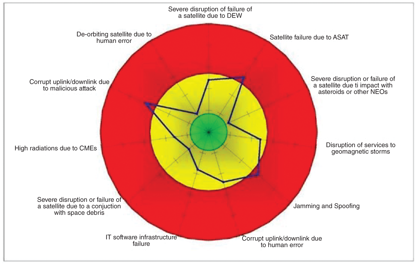
Figure 13.7 A general risk multimodel for the space–smart city relationship.
Society takes the increasing number of technological developments for granted, such as in the case of PNT or GNSS services. However, the failure of such services highlights massive societal failures in critical services, such as healthcare or governmental communications. In the case of a collapse in the essential infrastructures of space, it is quite possible that businesses and governments would continue operating but at significantly reduced levels of efficiency. Airlines would have to revert to legacy systems and procedures that waste expensive jet fuel on inefficient routes. Cargo vessels entering harbors would slow to a crawl to ensure safety, or they might not be allowed to dock at all. Container cranes at ports would revert to cumbersome manual operations. Logistical supply-chain management systems would lose or degrade their ability to track the flow of parts to their factories and products from warehouses. Construction and mining projects would become delayed as expensive manual labor replaced systems used to automate surveying, regrading, earth moving, and asset tracking. Farmers would lose the ability to operate twenty-four hours a day using automated machinery, and as a result, they may not be able to harvest all their crops before they spoil in the fields (Botezatu 2022; Georgescu et al. 2019; Nichols et al. 2022).
Furthermore, if a significant event – such as an earthquake, tsunami, forest fire, or other natural catastrophe – occurs on that same day, losing access to remote sensing satellites for a day can be crucial for border security and news reporting. It would be difficult to characterize that significant occurrence and thus to evaluate the damage that would negatively affect the rescue operations. Space essential infrastructures are subject to distinctly different hazards than other sectors’ crucial technologies, necessitating a different management approach and thinking style. For example, according to Kelso (2007), there were 2,864 operational satellites in all Earth orbits as of January 22, 2007. Two thirds of all payloads in low-Earth orbit, or 1,899 payloads, are at risk of being hit by debris from ASAT tests.
13.4.2 Possible Correlations Between Fragmentation Events and Smart Cities
The analysis of ASAT tests suggests that the fragmentation of objects in orbit could have impacted many critical infrastructures, including related services in smart cities. Satellites disintegrate as they re-enter the atmosphere, but some of the debris may be heat-resistant and continue to fall to Earth, increasing the likelihood of destruction. Unfortunately, because the density of Earth’s atmosphere is continually changing, it is complicated to anticipate exactly where debris will impact.
Each year during the previous ten years, around a hundred satellites and rocket bodies with a combined mass of about 150 tons have re-entered Earth’s atmosphere. Even though the exact mass is unclear, the re-entries of the two CZ-5B core stages in 2020 and 2021 were the largest uncontrolled re-entries since Salyut 7 in 1991 and will be the heaviest until 2025.
13.4.3 A System of Systems Approach to Security System Architectures
At both the discursive and operational levels in cities and outer space, techniques have been used to attempt to control and manage security. The former indicates the politicization of the threat, which makes the issue at hand “visible” and threatens to make it easier to dispatch funding and access operational resources to solve it. The latter implies setting boundaries so that the identified threat can be contained and addressed. The modeling of the outer space events described in this research has demonstrated that vulnerabilities in outer space could trickle down to almost all critical sectors of smart cities. As the examples show, how various data flows are observed, tracked, separated, and addressed demonstrates that the concept of containment is taking more subtle forms of manifestation in practical terms. To borrow an idea from environmental criminology, containment of threats is less about designing fences and gates and more about finding the proper algorithm that sorts and comprises the malign elements while allowing the “good” flows to pass.
As shown by the scenarios examined in this chapter, neither individual nation-states nor local authorities fully comprehend the effects of a significant interruption of space services. Control rooms in smart cities and in ground stations do not communicate with each other. Identifying which space infrastructure needs to increase its level of resilience, conducting a thorough analysis of security-related critical dependencies of our urban-specific societies and economies to particular space assets, and evaluating the level of redundancies already in place are some steps we could take to reduce our vulnerability to shortages and disruptions of critical space-based services.
A “security-by-design” strategy would encourage taking security needs into account for crucial city- and national-level systems . Additionally, the city-level security criteria should be considered when designing new space infrastructures or updating old ones and determining the acceptable vulnerability levels of new services. For instance, a set of minimum-security standards that must be satisfied while building satellites and ground components would lessen their susceptibility to hostile operations, such as cyberattacks. The development of such a set of universal basic security standards would need to be closely coordinated by nation-states and municipal governments.
Built-in security systems architecture resilience should involve all value chains, from creating capabilities for identifying and reducing present threats to establishing dynamic reaction capabilities in case the risks eventuate. In this case, resilience should start with the raw materials used in various technologies and end with the construction of resilient services for security and defense.
All these ideas, nevertheless, could find fertile land when thinking of smart cities and outer space services as bound together by a “system-of-systems” epistemology. Security system architectures are to expand their meaning into a more fluid, boundless, and rapidly changing environment. Moreover, the relationship between all these elements of the system of systems creates more than the sum of its parts.
Smart cities thus either make acquisitions from various companies or, in the best-case scenario, develop their own cloud-based software solutions. This implies that metropolitan authorities are limited to acting as middlemen between ground station owners and customers. Thus, access to critical information may be impeded by this chain of command. Given how many crucial infrastructure sectors rely on this constellation of commercial entities that solely follow market norms, this is a missing link from an operational, tactical, and primarily strategic perspective that should be considered.
13.5 Concluding Remarks
While advancements in space shift the focus from a military, government-centric perspective of security, aspects of governance are also be reinvented, marking the shift toward commercial interests. Governance as a process of consensus-making among all stakeholders thus becomes a quest for finding the middle ground between strengthening national sovereignty and promoting economic benefits of increasingly fragmented commercial actors. Security discussions have become more complex and multifaceted. Using the systems-of-systems framework, these topics of interest could be analyzed and understood better. Firstly, in terms of technologies developed, at the pace of the current boom, humanity will soon have fully automated systems in place, complex on-board satellite processing capabilities, or autonomous satellite-to-satellite communications. Nevertheless, these technologies that integrate artificial intelligence and machine learning elements introduce new vulnerabilities and are based on complex algorithms that reflect how societal perspectives are formed. Therefore, it is essential to stress how language and imagination create the basis for future algorithms and decisions in this realm.
Moreover, the cyber aspects of warfare are becoming prominent. This adds to the already growing capabilities of electronic warfare and is likely to expand even more. These typologies of hybrid warfare could impact both outer space and cities. The governance of security is a systemic socio-spatial process that connects material and non-material systems, including institutions and practices, along with various logics, intentions, perceptions, and histories. The relationship between parts of these systems plays a great role in diminishing the disruptive effects of the domino effects that could have very diverse causes. The current research has aimed to disentangle and highlight a part of this process, looking not only at the governance of security but also going deeper into the process of interactions through the laws, norms, power, and language of an organized society. The research has thus tried to un-black box the intricacies of contemporary security governance to offer ideas for improvement.
As a result, this study adds to the continuing discussions about the spatialization of security procedures and advances academic research in urban and space governance studies. Urban security, as a new spatial logic of flow and connectivity, represents a process where urbanized forms of outer politics and more spatialized forms of urban governance are mutually constitutive and a domain in which gaming can play a more significant role in creating resilient cities. Furthermore, complex system governance (Katina et al. 2021; Keating and Katina 2019; Keating et al. 2014, 2022) provides a fertile ground for the concatenations among outer space, smart cities, and governance.
13.6 Exercises
1 Discuss the need for a smart city in the twenty-first-century landscape.
2 Develop an illustrating model of interdependence between urban and space systems.
3 Discuss the importance of a system-of-systems approach in dealing with risks and vulnerabilities in space systems.
4 Discuss the importance of a system-of-systems approach in dealing with risks and vulnerabilities in a smart city.
5 Discuss the possible contributions of governance to smart city and critical space infrastructures.
References
- Australian Space Weather Forecasting Centre. (2022). Power failure in Canada during 1989. c=AU; co=Commonwealth of Australia; ou=Department of Sustainability, Environment, Water, Population and Communities; ou=Central Office; ou=Bureau of Meteorology; ou=Space Weather Services. https://www.sws.bom.gov.au/Educational/1/3/12.
- Botezatu, U.E. (2022). Defensible smart cities: A system-of-systems approach for vertically integrated spaces. Dissertation, Universitatea Politehnica Bucureşti. https://upb.ro/orase-inteligente-aparabile-o-abordare-a-sistemului-de-sisteme-pentru-spatii-integrate-vertical-defensible-smart-cities-a-system-of-systems-approach-for-vertically-integrated-spaces-botezatu-ulp.
- Broadband Commission for Digital Development. (2013). The State of Broadband 2013: Universalizing Broadband. International Telecommunication Union. https://ifap.ru/library/book539.pdf.
- Calida, B.Y. and Katina, P.F. (2015). Modelling the 2008 financial economic crisis: Triggers, perspectives and implications from systems dynamics. International Journal of System of Systems Engineering 6(4): 273–301. https://doi.org/10.1504/IJSSE.2015.075487.
- Cannon, P. (2013). Extreme space weather: impacts on engineered systems and infrastructure. Royal Academy of Engineering. https://www.raeng.org.uk/publications/reports/space-weather-full-report.
- CENTRA Technologies. (2011). Geomagnetic storms (IFP/WKP/FGS(2011)4). Organisation for Economic Co-operation and Development. https://www.oecd.org/gov/risk/46891645.pdf.
- Faria, L.D.A., Silvestre, C.A.D.M., and Correia, M.A.F. (2016). GPS-dependent systems: Vulnerabilities to electromagnetic attacks. Journal of Aerospace Technology and Management 8(4): Article 4. https://jatm.com.br/jatm/article/view/632.
- Gebbers, R. and Adamchuk, V.I. (2010). Precision agriculture and food security. Science, 327(5967): 828–831. https://www.science.org/doi/10.1126/science.1183899.
- Georgescu, A., Gheorghe, A.V., Piso, M.-I et al. (2019). Critical Space Infrastructures: Risk, Resilience and Complexity. Springer International Publishing. https://www.springer.com/us/book/9783030126032.
- IFP Energies Nouvelles. (2018). Smart city: Energy challenges facing sustainable cities. IFPEN. https://www.ifpenergiesnouvelles.com/article/smart-city-energy-challenges-facing-sustainable-cities.
- Ioannides, R.T., Pany, T., and Gibbons, G. (2016). Known vulnerabilities of global navigation satellite systems, status, and potential mitigation techniques. Proceedings of the IEEE, 104(6): 1174–1194. https://doi.org/10.1109/JPROC.2016.2535898.
- Kappenman, J. (2010). Geomagnetic Storms and Their Impacts on the U.S. Power Grid (Meta-R-319). Oak Ridge National Laboratory. https://irp.fas.org/eprint/geomag.pdf.
- Karthikeyan, P., Katina, P.F., and Anandaraj, S.P. (2023). Approaches to Data Analytics and Internet of Things Through Digital Twin. IGI Global. https://doi.org/10.4018/978-1-6684-5722-1.
- Katina, P.F. and Gheorghe, A.V. (2023). Blockchain-enabled Resilience: An Integrated Approach for Disaster Supply Chain and Logistics Management (1st ed.). CRC Press.
- Katina, P.F., Pinto, C.A., Bradley, J.M. et al. (2014). Interdependency-induced risk with applications to healthcare. International Journal of Critical Infrastructure Protection 7(1): 12–26. https://doi.org/10.1016/j.ijcip.2014.01.005.
- Katina, P.F., Pyne, J.C., Keating, C.B. et al. (2021). Complex system governance as a framework for asset management. Sustainability 13(15): Article 15. https://doi.org/10.3390/su13158502.
- Keating, C.B. and Katina, P.F. (2019). Complex system governance: Concept, utility, and challenges. Systems Research and Behavioral Science 36(5): 687–705. https://onlinelibrary.wiley.com/doi/10.1002/sres.2621.
- Keating, C.B., Katina, P.F., and Bradley, J.M. (2014). Complex system governance: Concept, challenges, and emerging research. International Journal of System of Systems Engineering 5(3): 263–288. https://www.inderscienceonline.com/doi/abs/10.1504/IJSSE.2014.065756.
- Keating, C.B., Katina, P.F., Chesterman, C.W. (eds.). (2022). Complex System Governance: Theory and Practice. Springer International Publishing. https://link.springer.com/book/10.1007/978-3-030-93852-9.
- Kelso, T.S. (2007). Analysis of the 2007 Chinese ASAT test and the impact of its debris on the space environment. In: Proceedings of the Advanced Maui Optical and Space Surveillance Technologies Conference (ed. S. Ryan ed.) The Maui Economic Development Board. https://celestrak.org/publications/AMOS/2007/AMOS-2007.pdf.
- Krausmann, E., Felton, C., Murtagh, W. et al. (2014). Space Weather and Financial Systems: Findings and Outlook. European Commission Publications Office. https://publications.jrc.ec.europa.eu/repository/bitstream/JRC92297/lbna26882enn.pdf.
- Lyons, J. (2012). Documenting violations of international humanitarian law from space: A critical review of geospatial analysis of satellite imagery during armed conflicts in Gaza (2009), Georgia (2008), and Sri Lanka (2009). International Review of the Red Cross 94(886): 739–763. https://doi.org/10.1017/S1816383112000756.
- Mattern, S. (2021). A City is Not a Computer: Other Urban Intelligences. Princeton University Press. https://press.princeton.edu/books/paperback/9780691208053/a-city-is-not-a-computer.
- National Research Council. (2008). Severe Space Weather Events: Understanding Societal and Economic Impacts: A Workshop Report. National Academies Press. https://doi.org/10.17226/12507.
- Nichols, P.R.K., Carter, C.M., Hood, J.P. et al. (2022). Space Systems: Emerging Technologies and Operations. New Prairie Press. https://kstatelibraries.pressbooks.pub/spacesystems.
- North American Electric Reliability Corporation. (2010). High-impact, low-frequency event risk to the North American bulk power system: a jointly-commissioned summary report of the North American Electric Reliability Corporation and the US Department of Energy’s November 2009 Workshop. Department of Energy. https://www.energy.gov/ceser/articles/high-impact-low-frequency-risk-north-american-bulk-power-system-june-2010.
- North American Electric Reliability Corporation. (2012). Effects of geomagnetic disturbances on the bulk power system. North American Electric Reliability Corporation. https://www.oecd.org/gov/risk/46891645.pdf.
- Renn, O., Jovanovic, A., and Schröter, R. (2011). Future Global Shocks: Social Unrest. Organisation for Economic Co-operation and Development. https://pdf4pro.com/amp/view/oecd-ifp-project-on-future-global-shocks-cfbc9.html.
- Steinberger, J. (2008). A survey of satellite communications system vulnerabilities. Thesis, Air Force Institute of Technology. https://scholar.afit.edu/etd/2729,
- Van, W.J.-A. (2008). Space for peace? The use of space technology to monitor conflict trends and human security in Africa. Conflict Trends 2008(4): 12–17. https://journals.co.za/doi/10.10520/EJC16031.
- Zell, H. (March 2, 2015). Technological Affects of Space Weather Events. NASA. http://www.nasa.gov/mission_pages/sunearth/science/Tech-affects.html.